
Satellite Imaging Market Outlook: Size, Share, Trends, Growth Analysis, Competitive Landscape & Forecast, 2026-2033

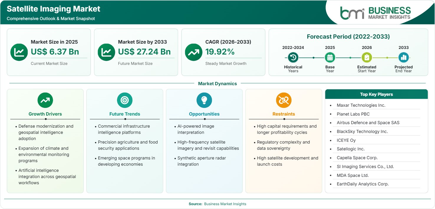
The Satellite Imaging Market size was valued at US$ 6.37 Billion in 2025 and is projected to reach US$ 27.24 Billion by 2033, growing at a CAGR of 19.92% during 2026–2033, driven by Earth observation demand, defense modernization, AI-enabled geospatial analytics, climate monitoring requirements, and expanding commercial applications across infrastructure, agriculture, energy, and disaster management.

Report Coverage
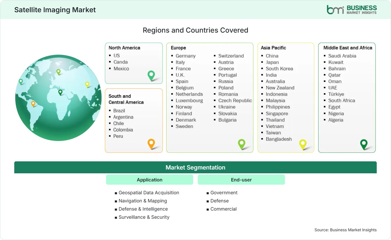
  • Application: Geospatial Data Acquisition, Navigation & Mapping, Defense & Intelligence, Surveillance & Security
  • End-user: Government, Defense, Commercial
US$ 6.37 Bn Market size in 2025
US$ 27.24 Bn Market Size by 2033
19.92% CAGR, 2026 - 2033
2026-2033 Forecast Period

AI Overview

Satellite Imaging Market Summary

  • North America Region: North America holds a market share of 36%–39% in 2025, growing with a CAGR of 18.5%–20.5% during 2026–2033. Strong defense procurement, commercial Earth observation investments, and AI-powered intelligence services support expansion across civil and military domains. US market benefits from advanced satellite constellations, government contracts, and commercial analytics adoption, expanding at 18.8%–20.8%.
  • Fastest Growing Region: Asia Pacific holds a market share of 24%–27% in 2025, growing with a CAGR of 22.0%–24.0% during 2026–2033. Rising space investments, agricultural intelligence requirements, smart-city initiatives, and national security modernization accelerate deployment of imaging satellites and analytics platforms.
  • Leading Segment: Defense & Intelligence accounts for 29%–32% share in 2025, advancing at a CAGR of 20.5%–22.5% during 2026–2033. Persistent surveillance demand, border monitoring programs, and geospatial intelligence integration strengthen procurement across governmental agencies worldwide.
  • High Growth Segment: Commercial end-user represents rapid expansion with a CAGR of 21.5%–23.5% during 2026–2033 and approximately 24%–27% share in 2025. Digital agriculture, energy infrastructure monitoring, insurance analytics, and logistics visibility stimulate adoption.
  • Key Market Opportunity: Integration of artificial intelligence with high-frequency satellite imagery enables predictive analytics, asset monitoring, climate intelligence, and automated change detection, creating scalable subscription-based revenue opportunities across industries globally.
  • Major Market Players: Maxar Technologies Inc., Planet Labs PBC, Airbus Defence and Space SAS, BlackSky Technology Inc., ICEYE Oy, Satellogic Inc., Capella Space Corp., SI Imaging Services Co., Ltd., MDA Space Ltd., and EarthDaily Analytics Corp.
Strategic Insights

Satellite Imaging Market: Strategic Insights

Satellite Imaging Market Strategic Framework
FREE PDF
Request your free sample
Request free sample
Stakeholder View

Key Takeaways

  • The industry ecosystem increasingly combines satellite operators, launch providers, cloud platforms, analytics vendors, and AI developers, creating a diversified value chain focused on decision intelligence rather than imagery sales.
  • Defense intelligence, commercial infrastructure monitoring, and geospatial data services present the strongest revenue upside due to rising data consumption and recurring analytics subscriptions.
  • Innovation is shifting toward AI-assisted interpretation, automated object detection, synthetic aperture radar integration, and multi-sensor fusion for continuous monitoring capabilities.
  • India, Japan, South Korea, the UAE, and Southeast Asian economies offer compelling investment cases due to growing space budgets and national geospatial programs.
  • Venture capital, strategic partnerships, and acquisitions increasingly target analytics providers that transform imagery into business intelligence products.
  • Climate-risk assessment and carbon monitoring applications are broadening revenue opportunities among environmental agencies, energy operators, and sustainability-focused enterprises.
Geographic Outlook

Satellite Imaging Market Regional Highlights

North America Satellite Imaging Market

North America represents 36%–39% of global revenue in 2025 and is forecast to expand at 18.5%–20.5% CAGR during 2026–2033. Commercial ecosystems, large budgets for military expenditure, Earth observation systems, and AI-powered geospatial analysis usage are some of the strengths of the region. The share of the Satellite Imaging Market is skewed in favor of the United States, but Canada’s investments in Earth observation technologies keep increasing. Applications of government procurement, infrastructure intelligence, climate observation, and military surveillance drive the demand in the region.

  • Defense modernization programs support continual procurement of high-resolution imagery and geospatial intelligence solutions.
  • Commercial operators increasingly monetize analytics platforms rather than raw image products, improving profitability.
  • Demand for climate resilience monitoring accelerates adoption among environmental agencies and utilities.
  • Infrastructure operators use satellite data for asset inspection, risk assessment, and maintenance planning.
  • Expanding synthetic aperture radar deployments improve all-weather observation capabilities.

US Satellite Imaging Market

The United States accounts for approximately 76%–80% of regional revenue and advances at 18.8%–20.8% CAGR through 2033. There is continuous demand for high-frequency Earth observation from federal government agencies, defense entities, and businesses. Innovation in analytics, cloud-based geospatial processing, and private satellite constellation will lead to increased competitiveness in the market. The country remains central to Satellite Imaging Market growth through continued public-sector procurement and venture-backed commercial expansion.

  • National security requirements support long-term imagery and analytics contracts.
  • Agriculture, insurance, and energy sectors increasingly deploy geospatial intelligence solutions.
  • AI integration improves image interpretation speed and operational decision-making.
  • Private space companies continue investing in advanced imaging constellations.

Europe Satellite Imaging Market

Europe holds 25%–28% share in 2025 and is projected to record CAGR of 18.8%–20.8% through 2033. Regional expansion is backed by climatological observation systems, Copernicus programs, sovereign space ventures, and environmental monitoring legislation. Germany is the leading region in terms of revenue production, while France boasts excellent satellite production capacity. The UK exhibits high growth prospects with an estimated expansion of over 20%. Satellite Imaging Market analysis highlights increasing demand for sustainability intelligence and infrastructure monitoring across European economies.

  • Copernicus ecosystem strengthens access to geospatial information and analytics development.
  • Climate compliance requirements drive adoption of environmental monitoring applications.
  • Transportation and energy operators increasingly use satellite-derived intelligence for operations.
  • Government-funded Earth observation missions support commercial ecosystem growth.
  • Defense investments enhance requirements for persistent surveillance capabilities.

Asia Pacific Satellite Imaging Market

Asia Pacific commands 24%–27% share in 2025 and records the fastest CAGR of 22.0%–24.0% during the forecast period. National Space Policies, Urban Development Plans, Precision Farming Initiatives, and Maritime Surveillance drive the demand. China, Japan, and India are the dominant players in terms of revenue contribution, and India shows significant growth potential. Growing applications in commercial sector and satellite launches by the government help build regional competitiveness.

  • Smart-city investments increase requirements for mapping and urban intelligence platforms.
  • Agricultural digitization enhances demand for crop-monitoring imagery services.
  • Maritime security programs encourage adoption of monitoring and surveillance solutions.
  • Government funding supports domestic satellite manufacturing and constellation development.
  • Disaster management initiatives accelerate investment in real-time observation capabilities.

Rest of World Satellite Imaging Market

Rest of World accounts for 10%–13% share in 2025 and expands at CAGR of 20.0%–22.0% through 2033. Latin America gains from agricultural surveillance and management of natural resources regulations. The Middle East and Africa gain from increasing demand from infrastructure development, border security, and environment monitoring programs. Brazil continues to be a major player, but UAE shows impressive growth due to increased national space programs and technology development.

  • Agricultural exports encourage enhanced monitoring across Latin American economies.
  • Energy infrastructure operators increasingly deploy observation-based asset management solutions.
  • Gulf economies invest in sovereign space and Earth observation programs.
  • Border security monitoring supports procurement by defense organizations.
  • Climate resilience strategies create demand for environmental analytics services.
Global Market Geography
FREE PDF
Request your free sample
Request free sample
Segment Analysis

Satellite Imaging Market Segmentation

Application

Application segment accounts for core demand creation, with Defense & Intelligence leading at 29%–32% share in 2025 and expanding at 20.5%–22.5% CAGR. The Satellite Imaging Market scope continues broadening through digital infrastructure monitoring, climate intelligence, precision agriculture, and security applications. Growing data frequency and analytics sophistication enhance commercial value.

  • Geospatial Data Acquisition: Foundational imagery collection supports mapping, environmental assessment, infrastructure planning, and enterprise analytics requirements across public and private sectors globally.
  • Navigation & Mapping: High-resolution datasets improve route planning, mobility management, autonomous systems development, and smart-city infrastructure implementation.
  • Defense & Intelligence: Governments deploy advanced imagery for surveillance, reconnaissance, border monitoring, and threat assessment across strategic operations.
  • Surveillance & Security: Public agencies and critical infrastructure operators use observation platforms for risk monitoring and incident detection.

End-user

Government remains the largest end-user category with approximately 31%–34% share in 2025, while Commercial users exhibit the highest growth at 21.5%–23.5% CAGR. Satellite Imaging Market trends indicate accelerating enterprise adoption as analytics platforms become more accessible and scalable across industries.

  • Government: Public-sector organizations utilize imagery for environmental monitoring, land management, disaster response, and national development planning.
  • Defense: Military agencies employ geospatial intelligence capabilities to strengthen situational awareness and operational effectiveness.
  • Commercial: Businesses increasingly integrate satellite intelligence into agriculture, insurance, energy, mining, logistics, and infrastructure management workflows.
Market Forces

Satellite Imaging Market Dynamics

Key Market Drivers

Defense Modernization and Geospatial Intelligence Adoption

Global defense agencies are prioritizing space-based intelligence capabilities to improve situational awareness and operational preparedness. Increasing geopolitical uncertainty, surveillance demands at sea, and border security initiatives keep driving investments in advanced imagery capabilities. In today’s military context, reliance on continuous monitoring and intelligence derived from satellite constellations is becoming increasingly significant. The increased frequency of revisits, along with AI-based analysis, enables quicker response and decreased effort on the part of analysts. Geospatial intelligence systems are receiving growing budget shares within the domain of defense technologies.

Expansion of Climate and Environmental Monitoring Programs

Environmental agencies, research institutions, and energy operators increasingly rely on satellite-derived information to assess climate-related risks. The applications of such products may include forest fire detection, flood monitoring, emissions analysis, biodiversity evaluation, and resource management. There are international sustainable development campaigns and carbon accounting regulations that stimulate the wider use of observation equipment. There have been developments in terms of data analysis and processing that can help companies convert image data into environmental intelligence. The public investment in resilience planning and disaster prevention helps drive purchases from many areas.

Artificial Intelligence Integration Across Geospatial Workflows

AI technology is revolutionizing image analysis by automating the process of object detection, anomaly detection, land-use classification, and predictive analysis. Enterprises are becoming focused on results and not just image capture. By doing analytics automatically, processing time is reduced, costs are reduced, and scalability improves. It is easier for enterprises to analyze infrastructure, agricultural operations, transport networks, and industrial installations. The convergence of cloud computing, machine learning, and observation data continues driving commercial adoption while expanding usage among nontraditional customer segments.

Key Market Opportunities

Commercial Infrastructure Intelligence Platforms

Continuous visibility into transportation, utilities, pipelines, ports, and construction sites is becoming more of an imperative for infrastructure companies. Space-based analytics allow cost-effective situational awareness regardless of the geographical distribution of the assets. The demand is especially high when the inspection costs on site are relatively high and/or rare. Satellite Imaging Market Forecasts indicate growing enterprise expenditure on risk intelligence and asset monitoring solutions. Vendors capable of integrating imagery, AI interpretation, and workflow automation are positioned to capture expanding commercial demand across multiple industries and regions.

Precision Agriculture and Food Security Applications

Population growth, food security concerns, and resource optimization needs encourage adoption of satellite-enabled agricultural intelligence tools. The imagery technique is used by both farmers and agribusinesses in assessing crops' health status, yield projections, and irrigation. This technology is also applied by governments in enhancing food security planning. The reduction in costs and increase in analytical accessibility are some of the factors promoting its wider use by various agricultural stakeholders. There is an enormous market potential in developing countries with a major agricultural industry.

Emerging Space Programs in Developing Economies

Many developing nations are pursuing sovereign space capabilities to strengthen security, environmental management, and economic planning. The national satellite programs will always see partnerships between government and private organizations, offering a chance for equipment providers, imagery providers, and analytic companies. The investment pace is quickening in the Middle East, Southeast Asia, Africa, and Latin America. Nations are looking to gain independence strategically as well as upgrade their geospatial capabilities. Such a trend expands the user base and ensures future demand for these capabilities.

Market Restraints and Challenges

High Capital Requirements and Longer Profitability Cycles

Factor: Satellite development, launch services, ground infrastructure, data-processing systems, and constellation maintenance require substantial capital expenditure. Despite the reduced costs of launching, there remain heavy financial demands that need to be satisfied before the operator is able to achieve sustainable commercial operations. It could also entail other financial demands, such as the replacement of satellites, technology upgrades, expansion of networks, and improvements in the ground segment infrastructure.

Impact: High capital requirements can extend payback periods and increase financial risk, particularly for emerging companies with limited access to funding. Expectations are increasingly being set for companies to develop robust monetization techniques and a recurring revenue model with a path to profitability. Competitive pressures may also limit pricing, especially when there are several companies providing satellite data and related services. Margins will be compressed for those companies that cannot leverage analytics, unique datasets, applications, or add-on services to distinguish themselves.

Regulatory Complexity and Data Sovereignty

Factor: There are complex national laws concerning the resolution of satellite images, data export, privacy, geospatial security, and access to sensitive information. Providers that operate in several countries have to follow varying licensing and national security protocols, data management guidelines, and limits on the distribution of certain geospatial data. The laws and policies in different countries can differ significantly, and they can vary over time.

Impact: In addition, regulations can cause fragmentation of market entry and compliance cost increases for service providers who wish to expand their services internationally. Satellite launches, business partnerships, data sharing, and contract formation will be delayed by companies until all necessary permissions are received. In turn, data sovereignty can stimulate localized storage and processing infrastructure development that involves additional capital and operational expenses. Regulatory proficiency, compliance framework, and regional partnerships make it easier for companies to meet the regulations. Nonetheless, disparities in regulation can remain a barrier to market expansion.

Company Analysis

Competitive Landscape

Satellite Imaging Market analysis indicates competition is increasingly centered on analytics capabilities, revisit frequency, and integrated intelligence platforms.

Company Name

Overview

Products and Services relevant to this market

Maxar Technologies Inc.

Major geospatial intelligence provider serving government and commercial customers with advanced observation capabilities.

High-resolution imagery, geospatial intelligence, analytics platforms, and satellite observation services.

Planet Labs PBC

Operates one of the largest Earth observation constellations globally with daily coverage capabilities.

Earth observation imagery, monitoring solutions, AI-enabled analytics, and geospatial data services.

Airbus Defence and Space SAS

European aerospace leader with strong Earth observation and satellite system expertise.

Optical imagery, geospatial services, satellite manufacturing, and intelligence solutions.

BlackSky Technology Inc.

Focuses on real-time geospatial intelligence and high-frequency monitoring applications.

Satellite imagery, intelligence software, analytics, and monitoring solutions.

ICEYE Oy

Leading synthetic aperture radar specialist supporting persistent observation requirements.

SAR imagery, disaster monitoring, insurance intelligence, and risk analytics.

Satellogic Inc.

Develops scalable observation constellations targeting government and commercial customers.

High-resolution imagery, mapping solutions, and Earth observation services.

Capella Space Corp.

Provides radar-based observation capabilities with all-weather imaging functionality.

SAR data products, monitoring services, and geospatial intelligence solutions.

SI Imaging Services Co., Ltd.

Geospatial information provider supporting governmental and industrial users.

Satellite imagery distribution, mapping data, and analytics services.

MDA Space Ltd.

Space technology company with strong Earth observation and mission systems expertise.

Satellite systems, geospatial technologies, and information services.

EarthDaily Analytics Corp.

Focuses on advanced observation data and analytical intelligence offerings.

Earth observation data, analytics platforms, and environmental intelligence solutions.

Trust & Transparency

Research Methodology

The market analysis combines proprietary research with secondary data from government agencies, company disclosures, regulatory filings, industry databases and expert interviews. Market estimates are validated through data triangulation, cross-market benchmarking and analyst review.

View Full Research Methodology

Questions Answered

Frequently Asked Questions

What does a Satellite Imaging Market Report typically evaluate?

A comprehensive report assesses market size, competitive positioning, technological developments, regional demand patterns, segmentation performance, investment activity, and future growth opportunities.

What differentiates leading vendors in the industry?

Competitive differentiation increasingly depends on revisit frequency, analytics sophistication, AI integration, image resolution, and industry-specific intelligence solutions.

How does synthetic aperture radar differ from optical imaging?

SAR imagery can capture data through clouds and at night, enabling continuous observation when optical systems face visibility limitations.

Which end-user category offers the strongest long-term opportunity?

Commercial users present the strongest long-term opportunity due to increasing adoption in insurance, energy, logistics, agriculture, and infrastructure management applications.

What factors are accelerating adoption of satellite imaging services?

Defense modernization, climate monitoring, infrastructure intelligence, precision agriculture, and AI-powered analytics are expanding demand across government and commercial sectors.

Access the Full Satellite Imaging Market Report

Get segment-level forecasts, regional estimates, competitive benchmarking, company profiles and downloadable Excel datasets.

Access the full Satellite Imaging Market Report
350 pages PDF & Excel | 2026-09-02