
Remote Sensing Satellite Market Outlook: Size, Share, Trends, Growth Analysis, Competitive Landscape & Forecast, 2026–2033

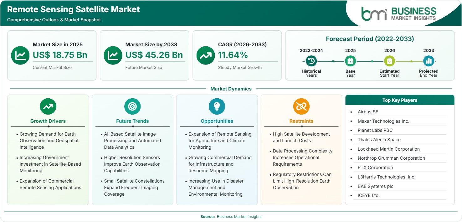
The Remote Sensing Satellite Market size was valued at US$ 18.75 Billion in 2025 and is projected to reach US$ 45.26 Billion by 2033, growing at a CAGR of 11.64% during 2026–2033, driven by Earth observation demand, government monitoring, commercial geospatial services, climate intelligence, agriculture, and disaster response.

Report Coverage
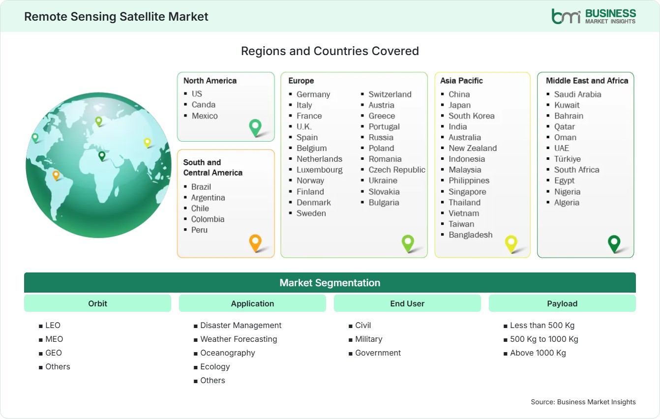
  • Orbit: LEO, MEO, GEO, Others
  • Application: Disaster Management, Weather Forecasting, Oceanography, Ecology, Others
  • End User: Civil, Military, Government
  • Payload: Less than 500 Kg, 500 Kg to 1000 Kg, Above 1000 Kg
US$ 18.75 Bn Market size in 2025
US$ 45.26 Bn Market Size by 2033
11.64% CAGR, 2026 - 2033
2026-2033 Forecast Period

01 AI Overview

Remote Sensing Satellite Market Summary

  • North America Region: North America holds a 28%–32% share in 2025 and grows at a 10.8%–11.6% CAGR during 2026–2033, supported by defense intelligence, commercial imagery, disaster monitoring, infrastructure mapping, and government procurement. The US market remains dominant, supported by defense demand, commercial satellite operators, geospatial analytics, and increasing use of high-frequency Earth observation data, with a 10.9%–11.7% CAGR during 2026–2033.
  • Fastest Growing Region: Asia Pacific holds a 25%–29% share in 2025 and grows at a 12.5%–13.4% CAGR during 2026–2033, supported by expanding space programs, agricultural monitoring, disaster management, urban development, environmental observation, defense requirements, and commercial geospatial applications.
  • Leading Segment: LEO holds a 62%–66% share in 2025 and grows at an 11.8%–12.5% CAGR during 2026–2033, supported by lower deployment costs, frequent revisit capability, constellation scalability, high-resolution imaging, and expanding commercial and government Earth observation requirements.
  • High Growth Segment: Disaster Management holds a 15%–19% share in 2025 and grows at a 13.8%–14.6% CAGR during 2026–2033, supported by rapid situational awareness requirements, flood monitoring, wildfire assessment, emergency mapping, infrastructure damage assessment, and climate-related risk management.
  • Key Market Opportunity: Increasing demand for high-frequency, multi-sensor Earth observation is creating opportunities for constellation operators, satellite manufacturers, analytics providers, and integrated platforms delivering faster, actionable geospatial intelligence.
  • Major Market Players: Airbus SE, Maxar Technologies Inc., Planet Labs PBC, Thales Alenia Space, Lockheed Martin Corporation, Northrop Grumman Corporation, RTX Corporation, L3Harris Technologies, Inc., BAE Systems plc, ICEYE Ltd.
02 Strategic Insights

Remote Sensing Satellite Market: Strategic Insights

Remote Sensing Satellite Market Strategic Framework
FREE PDF
Request your free sample
Request free sample
03 Stakeholder View

Key Takeaways

  • The satellite providers are shifting from using a single satellite approach to utilizing the constellation architecture which ensures high revisit rate, reliability, coverage, and resilience while spreading out risks.
  • Commercial usage of satellites is increasing in such industries as agriculture, infrastructure, insurance, natural resource management, logistics, and environmental monitoring.
  • Optical and radar payloads are increasingly being combined to improve observation continuity, particularly where cloud cover, darkness, smoke, or adverse weather can limit conventional optical imaging.
  • Asia Pacific offers strong investment potential because governments and private operators are expanding domestic satellite capabilities while demand for mapping, agriculture, environmental monitoring, and disaster intelligence increases.
  • Competitive positioning is increasingly influenced by constellation scale, revisit capability, image resolution, data-processing speed, vertical integration, and the ability to convert raw imagery into decision-ready intelligence.
  • Long-term value is shifting toward recurring data and analytics services because customers increasingly prefer continuous monitoring and actionable insights instead of one-time satellite imagery purchases.
04 Geographic Outlook

Remote Sensing Satellite Market Regional Highlights

North America Remote Sensing Satellite Market

North America holds a 28%–32% share in 2025 and North America Remote Sensing Satellite Market forecast to grow at a 10.8%–11.6% CAGR through 2033. The US represents the dominant regional demand base, supported by defense intelligence, commercial imagery, infrastructure monitoring, and disaster management. Canada contributes through environmental observation, resource mapping, and climate monitoring. The share reflects strong demand for high-resolution imagery, SAR, persistent monitoring, and integrated analytics. Regional suppliers increasingly combine satellite assets with cloud platforms and geospatial intelligence services.

  • Defense and intelligence requirements continue supporting demand for high-resolution optical, radar, multispectral, and persistent monitoring capabilities across government programs and security applications.
  • Commercial operators are expanding constellation capacity to provide frequent imagery, enabling customers to monitor infrastructure, agriculture, environmental conditions, and asset activity more consistently.
  • Disaster-response organizations increasingly require rapid satellite-based assessments for floods, wildfires, storms, and infrastructure damage where ground access can be limited.
  • Increasing integration of AI and geospatial analytics allows satellite operators to move from imagery delivery toward automated detection, classification, monitoring, and decision support.

US Remote Sensing Satellite Market

The US Remote Sensing Satellite Market represents 80%–84% of North American demand in 2025 and grows at a 10.9%–11.7% CAGR through 2033. Defense, intelligence, infrastructure, agriculture, environmental monitoring, and commercial mapping support demand. The market benefits from an established aerospace ecosystem and strong private-sector participation.

  • Government and defense users remain major customers for secure imagery, persistent surveillance, geospatial intelligence, and mission-specific Earth observation capabilities.
  • Commercial operators are expanding subscription-based data services, improving accessibility for organizations that require continuous monitoring without owning satellite infrastructure.
  • Infrastructure, agriculture, insurance, and environmental customers increasingly use satellite-derived information to monitor changes and support operational planning.

Europe Remote Sensing Satellite Market

Europe Remote Sensing Satellite Market holds a 22%–26% share in 2025 and grows at a 10.2%–11.0% CAGR through 2033. Germany, France, the United Kingdom, Italy, and Spain represent leading markets, while France and Germany provide strong high-technology demand. European programs emphasize environmental monitoring, climate observation, agriculture, security, and strategic autonomy.

  • France remains an important satellite manufacturing and Earth observation center, supporting advanced optical systems, radar capabilities, defense intelligence, and commercial imagery services.
  • Germany contributes through satellite engineering, radar technologies, environmental monitoring, industrial applications, and growing sovereign space-intelligence requirements.
  • The United Kingdom provides opportunities in commercial Earth observation, climate monitoring, analytics, infrastructure intelligence, and downstream geospatial services.
  • Southern European markets support demand through agriculture, maritime monitoring, wildfire assessment, infrastructure development, and environmental observation requirements.

Asia Pacific Remote Sensing Satellite Market

Asia Pacific holds a 25%–29% share in 2025 and grows at a 12.5%–13.4% CAGR through 2033, making it the fastest-growing regional market. China, Japan, India, South Korea, and Australia represent leading markets, while India and Southeast Asia provide strong expansion opportunities. Government space programs, agricultural monitoring, disaster management, environmental protection, infrastructure development, and defense requirements are supporting demand.

  • China remains a major market because of its extensive satellite programs, government applications, environmental monitoring requirements, and expanding commercial Earth observation ecosystem.
  • India provides strong growth potential through agricultural monitoring, disaster management, urban planning, resource mapping, environmental observation, and expanding domestic space capabilities.
  • Japan and South Korea support advanced applications through established aerospace industries, environmental monitoring, defense requirements, precision mapping, and sophisticated satellite technology.
  • Southeast Asian countries provide emerging opportunities as governments and commercial organizations increase demand for disaster monitoring, agriculture intelligence, infrastructure mapping, and natural-resource assessment.

Rest of World Remote Sensing Satellite Market

Rest of World holds a 15%–19% share in 2025 and grows at a 10.0%–10.8% CAGR through 2033. South and Central America are led by Brazil, Mexico, Chile, Colombia, and Argentina, while Brazil and Chile provide stronger growth potential. Agricultural monitoring, forestry, mining, infrastructure development, disaster management, and environmental observation are key demand areas. The Middle East and Africa provide opportunities through security, agriculture, infrastructure, environmental monitoring, water management, and disaster assessment. Saudi Arabia, the UAE, South Africa, Israel, and Türkiye represent leading markets, while Saudi Arabia and the UAE offer stronger growth prospects. The Remote Sensing Satellite Market share across these regions remains influenced by government investment, local space strategies, climate pressures, resource management needs, and demand for independent geospatial intelligence.

  • Brazil provides substantial demand from agriculture, forestry, mining, environmental monitoring, land-use assessment, and infrastructure development requiring broad geographic coverage.
  • Middle Eastern markets increasingly require satellite monitoring for water resources, infrastructure, environmental conditions, security, and urban expansion under challenging climatic conditions.
  • African markets offer opportunities in agriculture, disaster management, natural-resource mapping, environmental monitoring, and infrastructure planning as satellite-data accessibility improves.
  • Latin American and African customers increasingly favor commercial imagery and analytics platforms that reduce the technical requirements associated with operating dedicated satellite infrastructure.
Global Market Geography
FREE PDF
Request your free sample
Request free sample
05 Segment Analysis

Remote Sensing Satellite Market Segmentation

Orbit

LEO holds a 62%–66% share in 2025 and grows at an 11.8%–12.5% CAGR through 2033, making it the leading orbit segment. Its scalability, revisit frequency, and suitability for high-resolution payloads support broad commercial and government adoption. The Remote Sensing Satellite Market scope increasingly favors distributed LEO constellations capable of continuous geographic coverage and rapid data delivery.

  • LEO: Low-Earth orbit supports frequent revisits, high-resolution imaging, smaller spacecraft architectures, and scalable constellations serving commercial monitoring and government intelligence requirements.
  • MEO: Medium-Earth orbit supports broader observation characteristics and selected specialized missions where coverage, orbital persistence, and mission architecture justify higher deployment complexity.
  • GEO: Geostationary orbit provides persistent observation over fixed geographic areas, making it relevant for weather monitoring, atmospheric observation, and continuous regional surveillance.

Application

Disaster Management holds a 15%–19% share in 2025 and grows at a 13.8%–14.6% CAGR through 2033, making it the high-growth application. Weather Forecasting and Oceanography maintain strong institutional demand, while Ecology benefits from environmental monitoring requirements. Increasing climate-related risks and demand for rapid geospatial intelligence are expanding satellite applications across public and commercial organizations.

  • Disaster Management: Satellite imagery supports rapid assessment of floods, wildfires, storms, landslides, and infrastructure damage where timely information is critical for response planning.
  • Weather Forecasting: Continuous atmospheric observation improves weather monitoring, supporting forecasting, climate analysis, severe-weather assessment, and operational planning across vulnerable regions.
  • Oceanography: Satellite observations support maritime monitoring, ocean conditions, coastal management, fisheries assessment, and environmental analysis across geographically extensive water bodies.
  • Ecology: Earth observation enables monitoring of forests, wetlands, vegetation, land-use change, biodiversity conditions, and ecosystem degradation across large territories.

End User

Civil users hold a 43%–47% share in 2025 and grow at a 11.0%–11.8% CAGR through 2033, supported by commercial mapping, agriculture, environmental monitoring, infrastructure, and disaster-response requirements. Government users maintain strong demand for national monitoring and public planning, while military applications benefit from secure imagery, persistent surveillance, intelligence, and strategic situational awareness.

  • Civil: Civil demand spans agriculture, mapping, infrastructure, environmental management, insurance, logistics, resource monitoring, and commercial geospatial intelligence services.
  • Military: Military users require secure, timely, high-resolution intelligence for surveillance, reconnaissance, operational planning, border monitoring, and strategic situational awareness.
  • Government: Government agencies use satellite information for environmental programs, disaster management, land administration, urban planning, climate monitoring, and national resource management.

Payload

Payloads below 500 Kg hold a 48%–52% share in 2025 and grow at a 12.0%–12.8% CAGR through 2033. Smaller payload architectures align with LEO constellations, lower launch requirements, and scalable commercial missions. Larger payload classes remain relevant for high-capability missions requiring sophisticated sensors, greater onboard resources, and specialized government or scientific applications.

  • Less than 500 Kg: Smaller payloads support cost-efficient constellation architectures, rapid deployment, high revisit rates, and commercial missions requiring scalable Earth observation coverage.
  • 500 Kg to 1000 Kg: Mid-sized payloads balance sensor capability, spacecraft resources, launch requirements, and mission flexibility for sophisticated observation programs.
  • Above 1000 Kg: Larger payloads support complex missions requiring advanced sensors, greater power availability, extensive onboard systems, and specialized observation capabilities.
06 Market Forces

Remote Sensing Satellite Market Dynamics

Key Market Drivers

Growing Demand for Earth Observation and Geospatial Intelligence

Growing dependence on geospatial data will fuel growth in satellite demand in military operations, infrastructure development, farming, environmental monitoring, marine surveillance, and disaster management applications. Users require their information promptly and quickly without having to conduct extensive field surveys since geospatial information can detect changes in wide geographic zones. Optical, multi-spectral, hyperspectral, and SAR sensors allows operators to deliver different types of intelligence depending on the application needs. The Remote Sensing Satellite Market trends have been shifting towards high revisit constellations and integrated analytics.

Increasing Government Investment in Satellite-Based Monitoring

The government agencies are developing the capabilities of their satellites for the purposes of environmental observation, disaster response, natural resources management, defense intelligence gathering, and national planning. The sovereign infrastructure for observation has become a strategic requirement due to the fact that governments require an assured access to the geospatial information without being completely dependent on third-party sources. The need of governments is helping in the purchase of satellites, payload equipment, ground stations, processing of data, and analysis capability. There are satellite programs incorporating optical and radar sensors for wider observations.

Expansion of Commercial Remote Sensing Applications

Commercial use of satellite information is expanding because organizations increasingly need geographically comprehensive monitoring without deploying large physical inspection networks. Agriculture companies can use imagery to assess crop conditions, while infrastructure operators can monitor construction, assets, and land movement. Insurance providers can use satellite information for risk assessment and claims support, while resource industries can improve exploration and environmental monitoring. The Remote Sensing Satellite Market growth is therefore becoming increasingly diversified across non-government applications.

Key Market Opportunities

Expansion of Remote Sensing for Agriculture and Climate Monitoring

Agriculture and climate monitoring provide significant opportunities because both applications require repeated observation over large geographic areas. Satellite data can support crop-condition assessment, land-use monitoring, vegetation analysis, water management, and environmental change detection. Climate-related monitoring also requires consistent information on forests, coastal areas, ice, vegetation, and atmospheric conditions. Commercial operators can develop specialized products that combine satellite imagery with weather information, geographic datasets, and analytics. This creates opportunities beyond selling raw imagery and allows providers to offer decision-support services.

Growing Commercial Demand for Infrastructure and Resource Mapping

Infrastructure development, mining, energy, transportation, utilities, and construction require continuous information about large and difficult-to-access areas. Satellite observation can support site assessment, construction monitoring, asset mapping, terrain analysis, environmental compliance, and change detection. Commercial providers can increase value by integrating imagery with three-dimensional models, geographic information systems, and automated alerts. The opportunity is strongest where customers manage dispersed assets or require frequent updates across extensive territories.

Increasing Use in Disaster Management and Environmental Monitoring

Disaster management necessitates quick information before, during, and after the major disasters occur, giving rise to high demands for satellite systems that have the capability of quick observation and quick data transmission. Radar satellites are quite helpful when clouds, smoke, and darkness hinder optical observation. Environmental observation leads to a similar demand for monitoring the forest areas, coastlines, water resources, land degradation, and ecological changes. Service providers may devise a range of special services that would be capable of identifying changes and informing relevant authorities.

Market Restraints and Challenges

High Satellite Development and Launch Costs

Factor: Development of satellites involves significant capital expenses on the design of spacecraft, their integration with payload, testing, infrastructure development, launching, and operations of the mission. Impact: A high amount of initial cost can be a constraint as well as an increased exposure to risk in case of delay, technical failure, or underperformance hindering the market growth. Ridesharing and smaller satellite structures can make the constraint less important; however, complex missions still require significant engineering efforts.

Data Processing Complexity Increases Operational Requirements

Factor: Modern remote sensing missions generate large volumes of multi-spectral, radar, and high-resolution data requiring substantial processing, storage, calibration, validation, and analytics infrastructure. Impact: Complex data workflows increase operating requirements and can raise costs for providers that must deliver timely, accurate, and application-ready information. Companies that build automated processing pipelines and standardized data products can reduce these pressures while improving delivery speed and consistency.

07 Company Analysis

Competitive Landscape

Remote Sensing Satellite Market analysis shows competition across satellite manufacturing, payload technologies, Earth observation constellations, defense intelligence, geospatial data, and integrated mission services. Competitive positioning increasingly depends on constellation scalability, sensor performance, revisit capability, secure data access, analytics, ground infrastructure, and long-term government or commercial relationships.

Company Name

Overview

Products and Services relevant to this market

Airbus SE

Major aerospace company with extensive Earth observation satellite manufacturing and geospatial intelligence capabilities.

Optical and radar satellites, satellite imagery, Earth observation systems, geospatial data, tasking, and analytics services.

Maxar Technologies Inc.

Earth observation and space technology company focused on high-resolution imagery and geospatial intelligence.

High-resolution satellite imagery, Earth observation satellites, geospatial intelligence, mapping, and satellite systems.

Planet Labs PBC

Commercial Earth observation company focused on frequent global imaging and data-driven geospatial intelligence.

Earth imaging satellites, daily imagery, monitoring platforms, geospatial datasets, and analytics services.

Thales Alenia Space

Major satellite manufacturer serving Earth observation, telecommunications, navigation, and government missions.

Earth observation satellites, radar systems, satellite platforms, payloads, mission integration, and ground solutions.

Lockheed Martin Corporation

Diversified aerospace and defense company supporting advanced spacecraft and national security missions.

Satellite systems, space platforms, sensors, mission systems, geospatial intelligence, and defense observation capabilities.

Northrop Grumman Corporation

Aerospace and defense company providing spacecraft, payloads, sensors, and mission solutions.

Satellite platforms, space sensors, payload integration, mission systems, and intelligence-oriented space technologies.

RTX Corporation

Aerospace and defense technology company providing advanced sensing and intelligence capabilities.

Sensors, space-based technologies, communications, intelligence systems, and advanced mission solutions.

L3Harris Technologies, Inc.

Defense technology company with capabilities in space sensors, intelligence, and mission systems.

Space sensors, imaging systems, intelligence technologies, payloads, communications, and mission integration.

BAE Systems plc

Defense and aerospace company providing sensing, intelligence, and space-related mission technologies.

Space-based sensing, intelligence systems, electronic technologies, mission solutions, and defense applications.

ICEYE Ltd.

Earth observation specialist focused on persistent SAR imaging and near-real-time geospatial intelligence.

SAR satellites, satellite imagery, persistent monitoring, disaster intelligence, defense solutions, and analytics platforms.

10 Trust & Transparency

Research Methodology

The market analysis combines proprietary research with secondary data from government agencies, company disclosures, regulatory filings, industry databases and expert interviews. Market estimates are validated through data triangulation, cross-market benchmarking and analyst review.

View Full Research Methodology

11 Questions Answered

Frequently Asked Questions

How can buyers use the Remote Sensing Satellite Market Report?

The Market Report can support strategic planning by evaluating orbit, application, competitive positioning, and emerging opportunities across the value chain.

What is increasing demand for commercial Earth observation?

Demand is expanding because agriculture, infrastructure, insurance, environmental management, mining, logistics, and resource industries increasingly require continuous geographic monitoring and faster access to decision-ready information.

How are smaller satellites changing the Remote Sensing Satellite Market?

Smaller spacecraft enable scalable constellations, shorter deployment cycles, flexible mission architectures, and more frequent observation. They allow operators to distribute coverage across multiple satellites rather than relying on individual large spacecraft.

Why are SAR satellites important for remote observation?

SAR systems can collect information regardless of daylight and are less affected by cloud cover, making them particularly valuable for infrastructure assessment, and persistent surveillance.

What factors determine the commercial value of a remote sensing satellite?

Commercial value depends on resolution, revisit frequency, sensor type, geographic coverage, and the provider’s ability to convert imagery into application-specific intelligence.

Access the Full Remote Sensing Satellite Market Report

Get segment-level forecasts, regional estimates, competitive benchmarking, company profiles and downloadable Excel datasets.

Access the full Remote Sensing Satellite Market Report
350 pages PDF & Excel | 2026-08-19