
Aerial Imaging Market Outlook: Size, Share, Trends, Growth Analysis, Competitive Landscape & Forecast, 2026-2033

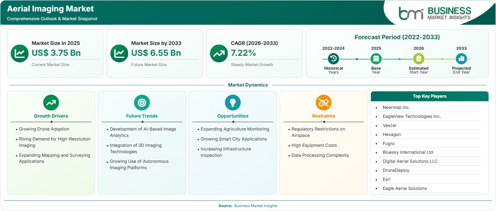
The Aerial Imaging Market size was valued at US$ 3.75 Billion in 2025 and is projected to reach US$ 6.55 Billion by 2033, growing at a CAGR of 7.22% during 2026–2033. Growth is driven by expanding drone deployment, rising geospatial intelligence requirements, advanced mapping technologies, infrastructure monitoring investments, precision agriculture adoption, and increasing demand for high-resolution location-based imaging solutions.

Report Coverage
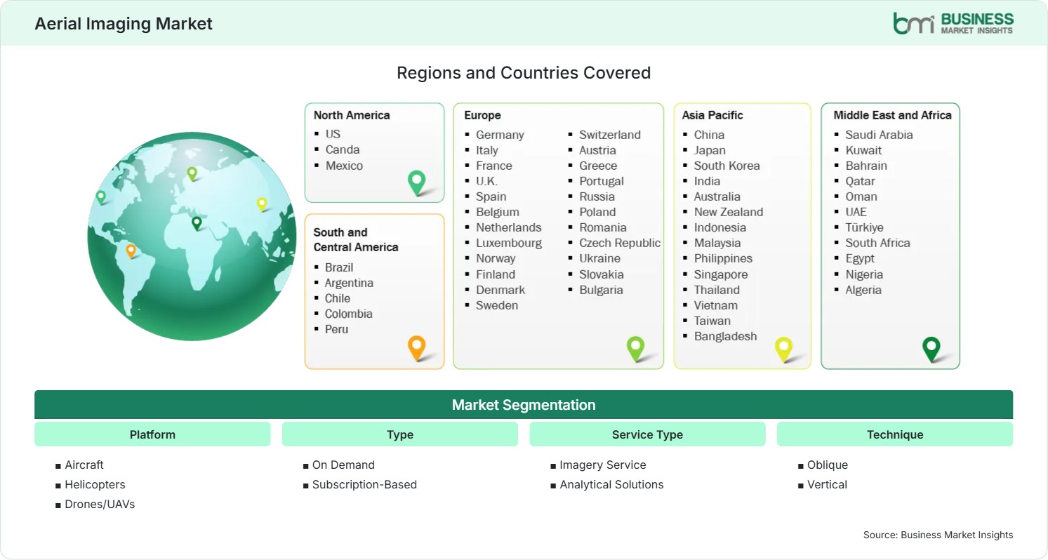
  • Platform: Aircraft, Helicopters, Drones/UAVs
  • Type: On Demand, Subscription-Based
  • Service Type: Imagery Service, Analytical Solutions
  • Technique: Oblique, Vertical
  • End Use: Real Estate & Architecture, Agriculture, Insurance, Environmental & Conservation, Commercial & Advertising, Others
US$ 3.75 Bn Market size in 2025
US$ 6.55 Bn Market Size by 2033
7.22% CAGR, 2026 - 2033
2026-2033 Forecast Period

01 AI Overview

Aerial Imaging Market Summary

  • North America Region: North America holds a market share of 36%–39% in 2025, growing with a CAGR of 6.8%–7.2% during 2026–2033. Demand is influenced by widespread drone adoption, advanced geospatial technologies, construction digitization, insurance assessment requirements, infrastructure modernization, environmental monitoring initiatives, smart mapping investments, and public-sector data acquisition programs. The U.S. remains the dominant contributor, supported by strong geospatial technology adoption and a CAGR of 6.9%–7.3%.
  • Fastest Growing Region: Asia Pacific holds a market share of 24%–27% in 2025, growing with a CAGR of 8.4%–8.9% during 2026–2033. Industrial digitalization, smart-city development, transportation infrastructure expansion, precision agriculture adoption, rising commercial drone utilization, urban planning modernization, and government-supported geographic information initiatives continue accelerating regional demand.
  • Leading Segment: Drones/UAVs account for 42%–45% of market share in 2025 and are forecast to expand at a 7.8%–8.2% CAGR during 2026–2033. Cost-efficient deployment, operational flexibility, rapid data collection, improved sensor integration, and accessibility across commercial industries continue supporting widespread adoption.
  • High Growth Segment: Analytical Solutions represent 29%–32% share in 2025 and are projected to register a 9.0%–9.5% CAGR during 2026–2033. Growing demand for AI-driven image interpretation, predictive analytics, asset intelligence, automated monitoring, and decision-support capabilities is expanding solution adoption.
  • Key Market Opportunity: Emerging opportunities are centered on AI-enabled geospatial analytics, infrastructure digital twins, precision agriculture intelligence, climate monitoring programs, smart-city planning, and scalable drone-based imaging platforms supporting real-time operational decision-making.
  • Major Market Players: Nearmap Inc., EagleView Technologies, Inc., Vexcel Imaging GmbH, Hexagon AB, Fugro N.V., Bluesky International Limited, Digital Aerial Solutions LLC, DroneDeploy, Inc., Environmental Systems Research Institute, Inc. (Esri), and Eagle Aerial Solutions.
02 Strategic Insights

Aerial Imaging Market: Strategic Insights

Aerial Imaging Market Strategic Framework
FREE PDF
Request your free sample
Request free sample
03 Stakeholder View

Key Takeaways

  • The value chain is increasingly integrated, connecting drone manufacturers, sensor developers, imaging providers, analytics platforms, cloud-service operators, and geographic information system vendors to create comprehensive data intelligence ecosystems.
  • Precision agriculture, infrastructure inspection, and utility monitoring applications offer some of the strongest growth opportunities because of the need for high-frequency, cost-efficient, and data-driven operational insights.
  • Innovation priorities are shifting toward artificial intelligence, machine learning, automated image classification, digital twin creation, and real-time geospatial analytics capable of accelerating decision-making processes.
  • Asia Pacific presents a compelling investment opportunity due to rapid urbanization, large-scale infrastructure projects, expanding drone ecosystems, and increasing government investments in geospatial modernization initiatives.
  • Strategic collaborations between software providers, drone operators, and imagery specialists are becoming increasingly important as customers seek integrated visualization, analytics, and mapping capabilities from a single provider.
04 Geographic Outlook

Aerial Imaging Market Regional Highlights

North America Aerial Imaging Market

North America accounted for approximately 36%–39% of global revenue in 2025 and is projected to expand at a 6.8%–7.2% CAGR through 2033. Public infrastructure modernization programs, utility network inspections, and insurance property assessments continue generating strong demand. The Aerial Imaging Market share remains highest in industries requiring high-frequency spatial intelligence and precision analytics.

  • Drone-enabled inspection programs are replacing several traditional surveying approaches by reducing operational costs, improving worker safety, and accelerating data collection across infrastructure assets.
  • Insurance providers increasingly utilize aerial imagery for claims assessment, catastrophe modeling, and property valuation, improving operational efficiency and response times following major weather events.
  • Utility and energy operators continue expanding aerial monitoring programs to enhance asset visibility, vegetation management, and predictive maintenance capabilities.
  • Government agencies are investing in high-resolution mapping and geospatial modernization initiatives that support transportation planning, environmental monitoring, and emergency management activities.
  • Artificial intelligence integration is improving automated image interpretation, defect identification, and infrastructure condition assessment across numerous commercial applications.

US Aerial Imaging Market

The United States represents approximately 79%–83% of North American demand and is expected to register a 6.9%–7.3% CAGR through 2033. Strong commercial drone deployment, advanced GIS adoption, and significant infrastructure investment underpin market expansion. Construction firms, insurers, agricultural enterprises, and public agencies continue increasing utilization of aerial intelligence solutions.

  • Construction and engineering companies increasingly deploy aerial surveys to support site planning, project monitoring, and progress documentation activities.
  • Precision agriculture adoption is expanding through crop health assessments, irrigation monitoring, and yield optimization programs supported by aerial intelligence.
  • Enterprise demand for subscription-based geospatial data services continues increasing due to the need for regularly updated imagery.
  • Investments in digital infrastructure and smart-city initiatives are creating sustained demand for scalable mapping and analytical capabilities.

Europe Aerial Imaging Market

Europe held approximately 28%–31% market share in 2025 and is projected to grow at a 7.0%–7.4% CAGR through 2033. The region benefits from strong geospatial governance frameworks, environmental monitoring initiatives, and extensive infrastructure management requirements. Germany remains the largest market due to engineering, industrial, and mapping applications, while the United Kingdom demonstrates accelerated adoption driven by urban planning and asset management requirements.

  • Germany leads regional demand through extensive industrial mapping requirements and broad adoption of digital surveying technologies.
  • The United Kingdom represents one of the fastest-expanding markets due to smart infrastructure management and urban development programs.
  • Environmental monitoring initiatives across Europe are increasing reliance on frequent image acquisition and geospatial analytics platforms.
  • Transportation authorities continue deploying aerial intelligence solutions for railway, roadway, and utility corridor management programs.
  • Regulatory acceptance of commercial drone operations is supporting broader adoption across public-sector and commercial applications.

Asia Pacific Aerial Imaging Market

Asia Pacific accounted for approximately 24%–27% of global revenue in 2025 and is expected to record the fastest regional expansion at a 8.4%–8.9% CAGR through 2033. China remains the leading regional market due to extensive construction activity and drone manufacturing capabilities, while India exhibits exceptional Aerial Imaging Market growth driven by smart-city initiatives, land digitization projects, and increasing agricultural technology adoption.

  • China maintains a leading position through extensive infrastructure projects, smart-city deployment, and commercial drone utilization.
  • India is emerging as a high-growth geography supported by digital mapping projects, agricultural modernization, and transportation planning initiatives.
  • Southeast Asian nations are increasing investments in environmental intelligence, disaster response planning, and urban development programs.
  • Mining and resource-management applications are driving demand for aerial surveying and terrain-monitoring capabilities.
  • Expanding geospatial technology ecosystems are encouraging adoption among government agencies and enterprise users.

Rest of World Aerial Imaging Market

Rest of World represented approximately 8%–11% of market revenue in 2025 and is projected to expand at a 7.1%–7.6% CAGR through 2033. South and Central America benefit from agricultural monitoring, mining surveys, and environmental management activities. The Middle East and Africa are experiencing adoption growth through infrastructure planning, smart-city development, and utility asset management programs.

  • Brazil continues expanding usage for crop intelligence, environmental mapping, and resource management applications.
  • Mining and exploration activities across Latin America are increasing demand for detailed terrain and asset-monitoring data.
  • Middle Eastern smart-city projects are creating opportunities for advanced imaging, digital twins, and urban analytics services.
  • Utility providers across Africa are deploying aerial assessments to improve network visibility and maintenance planning.
  • Infrastructure modernization and geographic information initiatives continue supporting adoption across developing economies.
Global Market Geography
FREE PDF
Request your free sample
Request free sample
05 Segment Analysis

Aerial Imaging Market Segmentation

Platform

The platform segment represents the foundation of image acquisition operations across commercial and government applications. Drones/UAVs accounted for approximately 42%–45% market share in 2025 and are projected to expand at a 7.8%–8.2% CAGR through 2033. Lower operating costs, deployment flexibility, rapid mission execution, and continued improvements in imaging sensors are driving adoption. The Aerial Imaging Market scope continues expanding as organizations prioritize scalable and cost-efficient aerial data collection capabilities.

  • Aircraft: Fixed-wing aircraft remain essential for large-area mapping projects, national geospatial surveys, corridor mapping, and high-altitude image acquisition requiring extensive coverage and consistent imaging quality.
  • Helicopters: Helicopters support specialized urban surveys, utility inspections, emergency response operations, and infrastructure assessments where maneuverability and low-altitude imaging capabilities provide operational advantages.
  • Drones/UAVs: Drones are increasingly preferred for construction monitoring, agricultural intelligence, environmental assessments, and asset inspections due to flexibility, affordability, and high-frequency data collection capabilities.

Type

The type segment reflects changing customer preferences regarding access models and procurement strategies. Subscription-Based services represented approximately 56%–59% share in 2025 and are expected to grow at a 8.1%–8.5% CAGR through 2033. Organizations increasingly prefer recurring access to updated imagery, scalable analytics, and cloud-based delivery platforms. The Aerial Imaging Market trends indicate a continued shift toward predictable revenue models and continuous data services.

  • On Demand: Organizations utilize on-demand imaging for project-specific requirements, emergency assessments, construction milestones, and targeted geographic areas requiring immediate and customized data acquisition.
  • Subscription-Based: Subscription offerings provide continuous image updates, recurring analytics access, historical comparisons, and scalable geospatial intelligence, making them increasingly attractive across enterprise applications.

Service Type

Service type segmentation is evolving from image acquisition toward intelligence-driven solutions. Imagery Service held approximately 63%–66% share in 2025, while Analytical Solutions represent the fastest-growing category with a 9.0%–9.5% CAGR through 2033. Organizations increasingly seek actionable insights rather than raw imagery, encouraging providers to expand analytics capabilities and value-added services.

  • Imagery Service: High-resolution image acquisition remains the industry foundation, supporting surveying, planning, monitoring, inspection, and mapping requirements across multiple sectors.
  • Analytical Solutions: AI-driven analytics, automated feature extraction, change detection, predictive assessments, and digital twin generation are driving demand for advanced interpretation services.

Technique

Technique selection depends on intended application, spatial requirements, and analytical objectives. Vertical imaging accounted for approximately 58%–61% share in 2025 and is projected to grow at a 7.0%–7.4% CAGR through the forecast period. Strong demand from mapping, surveying, GIS, and planning applications continues supporting adoption. Oblique imagery is gaining relevance in modeling and visualization environments.

  • Oblique: Oblique imaging provides enhanced perspective views useful for property visualization, infrastructure assessments, urban modeling, and commercial presentation applications.
  • Vertical: Vertical imagery remains the preferred technique for mapping accuracy, geospatial analysis, land surveys, and geographic information system integration requirements.

End Use

The end-use segment demonstrates increasing diversification across commercial, industrial, and public-sector applications. Real Estate & Architecture accounted for approximately 25%–28% share in 2025 and is forecast to expand at a 7.1%–7.5% CAGR through 2033. Growing demand for digital visualization, project monitoring, and property intelligence is supporting adoption. The Aerial Imaging Market share increasingly reflects demand from industries seeking real-time, location-based operational insights.

  • Real Estate & Architecture: Property developers, architects, and planners use aerial imagery for visualization, project documentation, land evaluation, and development planning activities.
  • Agriculture: Precision farming applications leverage aerial intelligence for crop monitoring, irrigation management, input optimization, and productivity enhancement initiatives.
  • Insurance: Insurers utilize aerial imagery for property assessment, catastrophe response, risk evaluation, claims management, and underwriting efficiency improvements.
  • Environmental & Conservation (Urban Planning): Governments and planners rely on aerial intelligence for conservation projects, environmental monitoring, zoning analysis, and sustainable urban development initiatives.
  • Commercial & Advertising: Businesses increasingly use aerial content for marketing campaigns, promotional materials, brand storytelling, and immersive customer engagement strategies.
06 Market Forces

Aerial Imaging Market Dynamics

Key Market Drivers

Growing Drone Adoption

The rapid adoption of drones is reshaping aerial intelligence workflows across construction, mining, utilities, agriculture, and environmental monitoring applications. The need for more efficient and faster data gathering options has led to the increased importance of UAVs for companies in terms of the data gathering process. The development of automated flights, real-time navigation systems, advanced sensors, and cloud-based technology has provided additional opportunities for drone usage. In the Aerial Imaging Market trends, drones are being actively utilized by enterprises as part of regular inspection and monitoring activities. The increasing popularity of commercial UAV operations and the growing investments in the UAV environment contribute to aerial imaging service demand.

Rising Demand for High-Resolution Imaging

The demand for highly accurate imagery has grown in various industries that depend on spatial intelligence. Providers of infrastructure, insurance, urban planning, and environmental services need imagery that can detect asset condition, building defects, and land use change with higher accuracy. The development of LiDAR technology, multispectral sensors, AI analytics, and high-resolution cameras has considerably increased the quality of the data and analysis performed. As companies focus on using data-driven strategies, the Aerial Imaging Market growth becomes increasingly dependent on the value extracted from data analysis, rather than just collecting the images.

Expanding Mapping and Surveying Applications

Governments and businesses have accelerated investments in mapping and surveying programs, which enable geospatial intelligence programs that aid in infrastructure development, transportation, resource management, and land administration. Modern aerial imaging technology allows fast data acquisition and more accuracy than many other methods used for surveying. Geographic information systems, digital twins, and asset management tools increase the possibilities of using aerial surveys. Engineering contractors, utilities companies, municipalities, and environmental organizations more frequently turn to aerial surveying because of its ability to increase efficiency and make projects more visible. The digitization of the physical world and geographic information assets is continuously fueling the demand for imaging and surveying technologies.

Key Market Opportunities

Expanding Agriculture Monitoring

Precision agriculture is gaining traction among providers of aerial imagery as more farmers rely on technology-based methods to enhance their productivity and resource utilization. Through aerial imagery, one can assess the health of crops, optimize irrigation, predict crop yields, identify pests and monitor the performance of the fields. The use of multi-spectrum imaging, thermal imaging and artificial intelligence allows operators in the agricultural sector to make decisions based on facts while cutting down the cost of inputs. The Aerial Imaging Market Forecast is driven by the increasing uptake of smart farming techniques, growing need to boost agricultural productivity, and increased government backing of digital agriculture.

Growing Smart City Applications

The expansion of smart-city programs is creating significant demand for aerial imaging technologies capable of delivering comprehensive geospatial intelligence. The municipal administrations are making use of aerial data for various urban planning, transport management, infrastructure construction, environment monitoring, and public safety operations. High-resolution images and digital twins help planners get a better vision of the urban landscapes and increase decision-making accuracy. As smart cities and intelligent infrastructure continue getting investments, the need for aerial imaging platforms that can provide real-time monitoring is rising. This trend is providing recurring revenues for the geospatial intelligence and location-based services firms.

Increasing Infrastructure Inspection

Infrastructure inspection represents one of the fastest-expanding application areas for aerial imaging solutions. Owners of assets are using aerial technology to evaluate roads, bridges, railways, telecommunication towers, pipelines, and electricity transmission lines. The technologies help ensure the safety of workers conducting the inspection and reduce the costs of carrying out the inspections. They also ensure coverage of all areas in terms of the geographical spread that requires inspection. The use of artificial intelligence and automatic image analysis increases the effectiveness of these tools since the need for maintenance can be predicted prior to any failure of the asset.

Market Restraints and Challenges

Regulatory Restrictions on Airspace

Factor: Commercial aerial imaging operations must comply with diverse aviation regulations covering flight permissions, operating altitudes, privacy requirements, pilot certifications, and restricted airspace zones.

Impact: Compliance requirements can increase project timelines, limit deployment flexibility, and raise operating expenses. Organizations conducting cross-border operations frequently encounter inconsistent regulatory frameworks that complicate service delivery and expansion strategies. Restrictions on flights in urban areas, critical infrastructure zones, and sensitive locations may constrain data collection opportunities and reduce project scalability.

High Equipment Costs

Factor: Advanced aerial imaging solutions require substantial investment in UAV platforms, aircraft systems, LiDAR equipment, high-resolution sensors, imaging software, cloud infrastructure, and skilled personnel.

Impact: Elevated capital requirements can create barriers for smaller service providers and organizations with limited technology budgets. Long investment-recovery periods often lead to extended procurement cycles and more rigorous return-on-investment evaluations. Although technological advancements are gradually improving affordability, equipment and operational costs remain significant considerations for many end users.

07 Company Analysis

Competitive Landscape

The Aerial Imaging Market analysis reflects competition among specialized aerial-data providers, geospatial technology companies, mapping specialists, drone-platform businesses, and integrated analytical providers. Differentiation centers on acquisition capabilities, data quality, geographic coverage, processing efficiency, analytical functionality, recurring service models, and application expertise.

Company Name

Overview

Products and Services relevant to this market

Nearmap Inc.

Aerial imagery specialist focused on frequently updated geographic information and visual data for commercial users.

High-resolution aerial imagery, location intelligence, mapping data, property information, and recurring imagery access.

EagleView Technologies, Inc.

Geospatial imagery provider serving property-focused users through aerial information and analytical capabilities.

Aerial imagery, property intelligence, measurement solutions, visual analytics, and specialized property-related information services.

Vexcel

Geospatial technology company providing high-quality aerial imagery and geographic information products for professional users.

Aerial imagery, mapping data, imagery processing, geospatial datasets, and imagery-based analytical capabilities.

Hexagon

Technology company with broad geospatial capabilities supporting measurement, mapping, visualization, and digital asset workflows.

Geospatial software, aerial mapping technologies, imagery processing, visualization, surveying, and analytical solutions.

Fugro

Global geospatial and surveying specialist providing remote sensing and geographic information services across complex environments.

Aerial surveys, remote sensing, geospatial data, mapping, surveying, environmental information, and analytical services.

Bluesky International Ltd

Specialist aerial survey and mapping provider focused on detailed geographic information and imagery services.

Aerial imagery, mapping, survey services, geographic datasets, environmental information, and imagery-based products.

Digital Aerial Solutions LLC

Aerial-data specialist providing collection capabilities designed around mapping, surveying, and specialized customer requirements.

Aerial imagery, mapping, surveying, data acquisition, image processing, and project-specific geographic information services.

DroneDeploy

Drone technology and software provider supporting aerial data capture, processing, visualization, and operational workflows.

Drone mapping, flight management, imagery processing, site documentation, visualization, and analytical workflow software.

Esri

Geospatial technology company integrating geographic information with mapping, analysis, visualization, and organizational workflows.

GIS platforms, imagery management, spatial analysis, mapping, visualization, geospatial analytics, and aerial-data integration.

Eagle Aerial Solutions

Aerial imagery and mapping specialist serving customers requiring visual geographic information and survey support.

Aerial photography, mapping, imagery collection, surveying, geographic documentation, and application-specific aerial services.


10 Trust & Transparency

Research Methodology

The market analysis combines proprietary research with secondary data from government agencies, company disclosures, regulatory filings, industry databases and expert interviews. Market estimates are validated through data triangulation, cross-market benchmarking and analyst review.

View Full Research Methodology

11 Questions Answered

Frequently Asked Questions

What does an Aerial Imaging Market Report help businesses evaluate?

The report can support evaluation of platforms, service models, techniques, applications, competitive positioning, customer requirements, analytical capabilities, and opportunities across the broader aerial-data value chain.

Which applications can benefit from oblique imagery?

Oblique imagery provides angled perspectives that can improve visualization of buildings, structures, property features, facades, and complex environments where downward-facing imagery alone may not provide sufficient contextual information.

How do analytical solutions improve the value of aerial imagery?

Analytical solutions convert captured imagery into measurements, classifications, comparisons, visualizations, and decision-support information.

Why are subscription-based services becoming strategically important?

Subscription models can provide recurring access to updated information, supporting customers that require continuous geographic awareness, historical comparison, and repeated monitoring instead of isolated datasets.

What determines the choice between aircraft and drones for aerial collection?

Aircraft are generally suited to broad-area requirements, while drones provide greater flexibility for localized and repeatable projects.

Access the Full Aerial Imaging Market Report

Get segment-level forecasts, regional estimates, competitive benchmarking, company profiles and downloadable Excel datasets.

Access the full Aerial Imaging Market Report
350 pages PDF & Excel | 2026-08-21