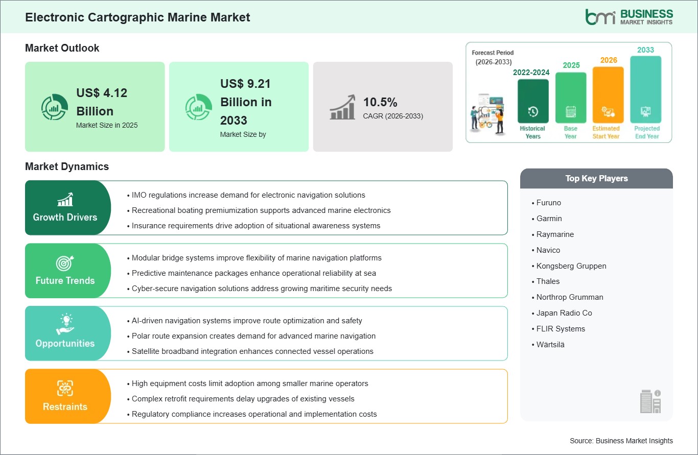
The electronic cartographic marine market size is expected to reach US$ 9.21 billion by 2033 from US$ 4.12 billion in 2025. The market is estimated to record a CAGR of 10.5% from 2026 to 2033.
Electronic cartographic marine's market is an integral part of modern maritime navigation systems, enabling precise digital mapping, route optimization, and real-time situational awareness for vessels operating across commercial, defense, and recreational segments. These systems utilize advanced electronic navigational charts, integrated positioning technologies, and dynamic oceanographic data to enhance voyage safety, operational efficiency, and decision-making at sea. As global maritime trade expands and navigation requirements become more complex, electronic cartography has evolved into a core component of digital marine ecosystems.
A key driver of the market is the increasing emphasis on maritime safety regulations and the adoption of standardized electronic navigation systems across international waters. Shipping operators and naval forces are progressively shifting from traditional paper charts to intelligent digital platforms that offer continuous updates, hazard detection, and automated route recalculations. The integration of satellite-based positioning, sonar mapping, and real-time weather data is further enhancing the accuracy and reliability of marine navigation, reducing the risk of accidents and improving fuel-efficient routing strategies.
The market is also supported by advancements in smart shipping and autonomous vessel technologies. As the maritime industry moves toward automation and digital transformation, electronic cartographic systems are becoming essential for supporting autonomous navigation, collision avoidance, and remote vessel monitoring. The growing adoption of integrated bridge systems and fleet management platforms is further strengthening the role of electronic charting solutions in global maritime operations.
However, the market faces challenges related to high system integration complexity, cybersecurity vulnerabilities, and dependency on accurate real-time data inputs. Variability in data standards across regions and the need for continuous chart updates also create operational burdens for end users. Despite these constraints, increasing digitalization of maritime operations and the push toward intelligent, connected shipping ecosystems are expected to drive sustained demand for electronic cartographic marine solutions worldwide.

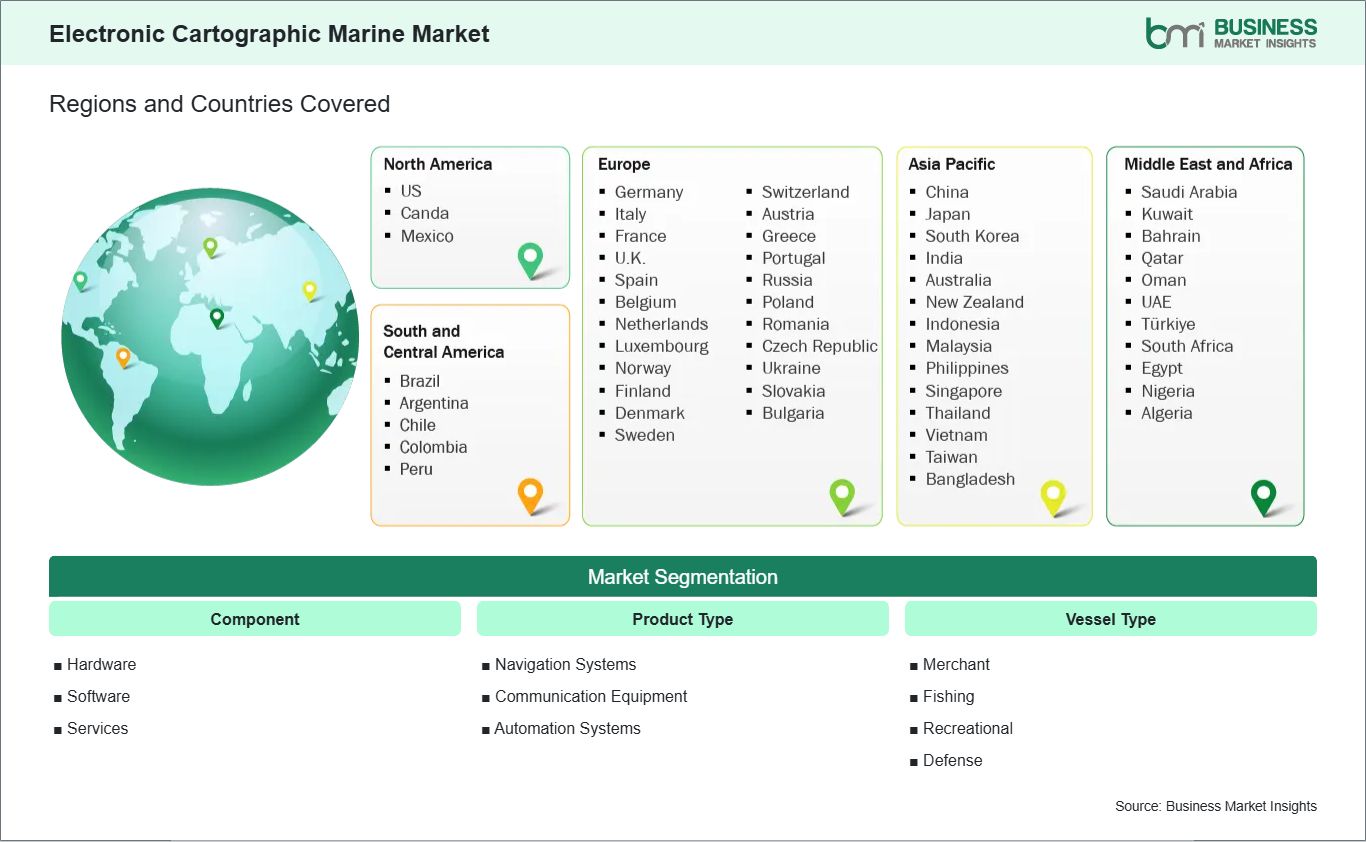
The electronic cartographic marine market is segmented based on component, product type, and vessel type, driven by the increasing adoption of advanced digital navigation, integrated marine electronics, and automated shipboard systems to enhance safety, operational efficiency, and situational awareness at sea.
The electronic cartographic marine market is expanding steadily as international maritime operations become more regulated and digitally enabled. An important factor is the stringent requirements imposed by international maritime authorities in relation to improved safety and navigation regulations, especially concerning the adoption of the electronic chart display and information system (ECDIS). Such measures have compelled ship owners to shift from the use of paper maps to a more technologically advanced digital map system.
As global trade volumes rise, vessel traffic density in major sea routes and ports has also increased, making accurate and real-time navigation data essential. The use of computer cartographic systems helps in updating navigation charts, route planning, and identifying dangers, thus improving situational awareness. Therefore, such technology has become an essential part of modern bridge equipment in cargo ships, tankers, and passenger liners.
Another important driver is the growing focus on maritime safety and accident prevention. The regulatory framework is becoming more concerned with collision prevention, environmental protection, and voyage planning. The electronic charting system can assist with these aspects by bringing together hydrographic information, weather reports, and navigation advisories into one digital environment. As compliance standards continue to evolve, demand for advanced marine charting systems is expected to strengthen further.
A major opportunity in the electronic cartographic marine market lies in the integration of AI-driven navigation systems. AI has been changing the way navigation in the marine environment works by providing services such as predicting routes and hazards along those routes using the constantly changing marine environments. With these advantages, the use of AI for cartography will become more popular.
AI-powered systems can analyze large volumes of maritime data, including currents, wind patterns, vessel traffic, and port congestion, to recommend optimal sailing routes. This not only decreases the time of voyage but also helps reduce the consumption of fuel. Moreover, machine learning models are able to learn from the historical data of voyages and feedback from sensors fitted on board vessels.
Another important opportunity is the integration of AI navigation with autonomous and semi-autonomous vessel technologies. In the development of the concepts of digitalizing and remote management of vessels, AI-driven cartography is gaining increasing importance for ship automation and the ideas of smart shipping. The technology serves not only as an important decision-support tool for crew personnel but will allow the future possibility of self-navigation through intelligent technology.
The electronic cartographic marine market is projected to grow from US$ 4.12 billion in 2025 to US$ 9.21 billion by 2033, registering a CAGR of 10.5% from 2026 to 2033.
By component, the hardware segment dominates the market as it forms the physical backbone of EWIS, including wires, cables, connectors, and related interconnection devices. These components are essential for ensuring reliable power distribution and signal transmission across complex aircraft systems, making hardware the largest contributor to overall demand.
By product type, communication equipment dominates the market due to the increasing reliance on advanced connectivity systems for real-time data exchange, navigation coordination, and operational safety. The growing integration of digital communication networks and satellite-based systems further strengthens EWIS requirements in this segment.
By vessel type, the defense segment dominates the market as modern naval and military vessels require highly sophisticated and reliable electrical wiring systems to support advanced navigation, combat systems, radar, and communication technologies. Rising defense modernization programs and naval fleet expansion continue to drive strong demand for EWIS in this category.
| Report Attribute | Details |
|---|---|
| Market size in 2025 | US$ 4.12 Billion |
| Market Size by | US$ 9.21 Billion in 2033 |
| Global CAGR (2026 - 2033) | 10.5% |
| Historical Data | 2022-2024 |
| Forecast period | 2026-2033 |
| Segments Covered | By Component
|
|
Regions and Countries Covered
| |
| North America | US, Canada, Mexico |
| Europe | Germany, Italy, France, U.K., Spain, Belgium, Netherlands, Luxembourg, Norway, Finland, Denmark, Sweden, Switzerland, Austria, Greece, Portugal, Russia, Poland, Romania, Czech Republic, Ukraine, Slovakia, Bulgaria |
| Asia-Pacific | China, Japan, South Korea, India, Australia, New Zealand, Indonesia, Malaysia, Philippines, Singapore, Thailand, Vietnam, Taiwan, Bangladesh |
| South and Central America | Brazil, Argentina, Chile, Colombia, Peru |
| Middle East and Africa | Saudi Arabia, United Arab Emirates, Kuwait, Bahrain, Qatar, Oman, Turkiye, South Africa, Egypt, Nigeria, Algeria |
| Market leaders and key company profiles |
|
The "Electronic Cartographic Marine Market Size and Forecast (2022-2033)" report provides a detailed analysis of the market covering below areas:
In terms of geographical distribution of the Electronic Cartographic Marine Market, there is a varied pattern of adoption based on factors such as global maritime trade activity, naval modernization programs, adoption of digital navigation systems, and increasing integration of advanced technologies like GPS, GIS, and real-time data analytics into marine charting solutions.
North America is a technologically advanced market for electronic cartographic marine systems, supported by strong naval defense capabilities, established commercial shipping routes, and continuous investments in maritime digitalization. The US and Canada are seeing an increased use of ECDIS, integrated bridges, and navigation systems among both civilian and military ships. The efforts taken by the region towards maritime safety regulations, modernization of ports, and digitalizing fleets are playing a role in boosting growth in the market. Moreover, developments in satellite navigation and hydrographical surveys are increasing the effectiveness of cartography applications in the marine sector.
Asia Pacific is the fastest-growing region in the electronic cartographic marine market, driven by high maritime trade volumes, expanding shipping fleets, and rapid port infrastructure development. Countries such as China, India, Japan, and South Korea have made significant contributions in terms of heavy investments in naval modernization and the development of commercial shipping. The area also enjoys the advantages that come with the increasing use of navigational technology, as it helps in the smooth movement of cargo and minimizes any risk in the process.
Both regions play a significant role in the expansion of the electronic cartographic marine market, driven by increasing maritime digitalization, rising emphasis on navigational safety, and the growing integration of advanced mapping, positioning, and real-time data technologies across commercial and defense marine operations.

The electronic cartographic marine market is evaluated by gathering qualitative and quantitative data post primary and secondary research, which includes important corporate publications, association data, and databases. Recent developments and news in the market include:
The Electronic Cartographic Marine Market is valued at US$ 4.12 Billion in 2025, it is projected to reach US$ 9.21 Billion in 2033 by .
As per our report Electronic Cartographic Marine Market, the market size is valued at US$ 4.12 Billion in 2025, projecting it to reach US$ 9.21 Billion in 2033 by . This translates to a CAGR of approximately 10.5% during the forecast period.
The Electronic Cartographic Marine Market report typically cover these key segments-
The historic period, base year, and forecast period can vary slightly depending on the specific market research report. However, for the Electronic Cartographic Marine Market report:
The Electronic Cartographic Marine Market is populated by several key players, each contributing to its growth and innovation. Some of the major players include:
The Electronic Cartographic Marine Market report is valuable for diverse stakeholders, including:
Essentially, anyone involved in or considering involvement in the Electronic Cartographic Marine Market value chain can benefit from the information contained in a comprehensive market report.
Please tell us your area of interest
(Market Segments/ Regions and Countries/ Companies)