
Drone Market Outlook: Size, Share, Trends, Growth Analysis, Competitive Landscape & Forecast, 2026-2033

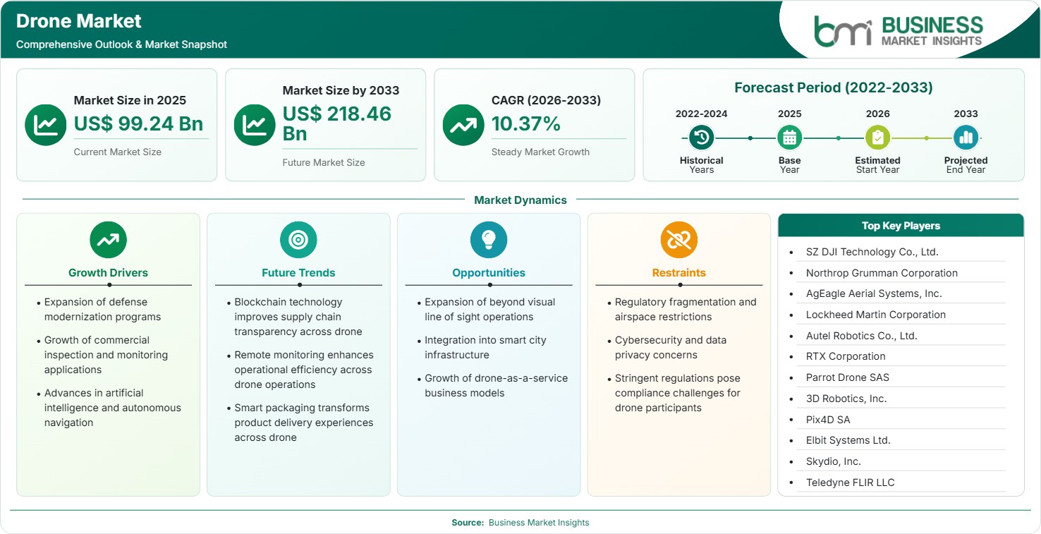
The Drone Market size was valued at US$ 99.24 Billion in 2025 and is projected to reach US$ 218.46 Billion by 2033, growing at a CAGR of 10.37% during 2026–2033. Expanding defense modernization programs, precision agriculture adoption, industrial inspections, AI-enabled autonomy, and growing commercial drone regulations are creating substantial opportunities across logistics, mapping, surveillance, emergency response, and infrastructure monitoring applications.

Report Coverage
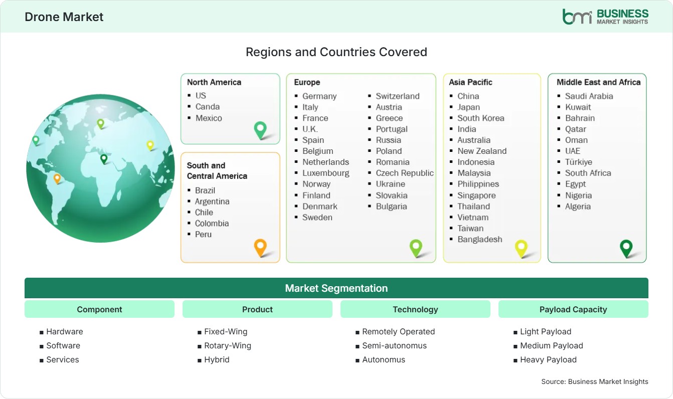
  • Component: Hardware, Software, Services
  • Product: Fixed-Wing, Rotary-Wing, Hybrid
  • Technology: Remotely Operated, Semi-autonomus, Autonomus
  • Payload Capacity: Light Payload, Medium Payload, Heavy Payload
  • Power Source: Battery Powered, Fuel Powered, Hybrid Powered
US$ 99.24 Bn Market size in 2025
US$ 218.46 Bn Market Size by 2033
10.37% CAGR, 2026 - 2033
2026-2033 Forecast Period

AI Overview

Drone Market Summary

  • North America Region: North America holds a market share of 34%–37% in 2025, growing with a CAGR of 9.4%–10.1% during 2026–2033, supported by defense procurement, enterprise drone deployment, BVLOS approvals, AI integration, infrastructure inspection demand, and public safety modernization initiatives across industries. The US accounts for most regional demand, supported by defense spending and commercial adoption, recording a CAGR of 9.5%–10.2%.
  • Fastest Growing Region: Asia Pacific holds a market share of 28%–31% in 2025, growing with a CAGR of 12.4%–13.2% during 2026–2033, driven by manufacturing leadership, agricultural digitization, urban surveillance deployment, logistics innovation, supportive regulations, and expanding investments in autonomous aerial technologies.
  • Leading Segment: Hardware holds a market share of 54%–58% in 2025, growing with a CAGR of 9.8%–10.6% during 2026–2033, supported by continuous demand for airframes, propulsion systems, sensors, navigation technologies, cameras, batteries, and mission-critical onboard equipment.
  • High Growth Segment: Software holds a market share of 18%–22% in 2025, growing with a CAGR of 13.5%–14.4% during 2026–2033, driven by AI-enabled analytics, fleet management platforms, digital twins, autonomous navigation systems, cloud integration, and advanced mission-planning applications.
  • Key Market Opportunity: Expanding beyond-visual-line-of-sight operations, autonomous delivery networks, smart city surveillance projects, and AI-driven aerial data analytics are creating long-term opportunities for technology providers, operators, software developers, and service integrators.
  • Major Market Players: SZ DJI Technology Co., Ltd.; Northrop Grumman Corporation; AgEagle Aerial Systems, Inc.; Lockheed Martin Corporation; Autel Robotics Co., Ltd.; RTX Corporation; Parrot Drone SAS; 3D Robotics, Inc.; Pix4D SA; Elbit Systems Ltd.; Skydio, Inc.; Teledyne FLIR LLC; Yuneec International Co., Ltd.
Strategic Insights

Drone Market: Strategic Insights

Drone Market Strategic Framework
FREE PDF
Request your free sample
Request free sample
Stakeholder View

Key Takeaways

  • The value chain is transforming itself from hardware-intensive manufacturing to ecosystems that incorporate aircraft, software platforms, connectivity technologies, analytical tools, and subscription-based revenue models.
  • Uses such as commercial inspections, precision agriculture, logistics support, and infrastructure surveillance promise the highest growth due to their ability to improve the efficiency of operations and decrease the cost of deploying the drones in the field.
  • The innovations focus on such areas as autonomous navigation, artificial intelligence in object recognition, swarming technology, edge computing, and improved batteries that increase flight duration.
  • The Asia Pacific region offers one of the best opportunities for investments due to its manufacturing capabilities, government-sponsored drone projects, agriculture modernization, and smart cities.
  • Strategic acquisitions will be increasingly centered on software developers, analytics companies, autonomous navigation firms, and manufacturers of sensors.
  • Advances in regulations concerning BVLOS flights will unlock commercial deployment opportunities in the logistic, inspection, rescue, and public services industries.
Geographic Outlook

Drone Market Regional Highlights

North America Drone Market

North America accounted for approximately 34%–37% of global revenue in 2025 and is projected to expand at a CAGR of 9.4%–10.1% through 2033. Defense modernization programs, commercial inspection demand, and increasing regulatory support for advanced operations continue supporting market expansion. The region benefits from mature technology ecosystems, strong venture capital participation, and advanced research capabilities. Drone Market share remains highest in North America due to extensive deployment across military, public safety, utility, energy, and infrastructure applications.

  • The defense agencies are continually funding the development of autonomous surveillance and reconnaissance technologies, hence increasing the need for advanced aerial technology within their operations.
  • The utilities companies are increasingly using aerial technology in conducting transmission line inspections.
  • With increased efficiency in monitoring the pipelines, offshore structures, and renewable energy systems, the energy companies are embracing aerial inspection technology.
  • The public safety agencies are continually deploying aerial technology in conducting search-and-rescue, disaster response, and coordination operations.
  • The integration of aerial technology with enterprise software applications is generating recurring revenues through fleet management, analytics, compliance, and mission optimization solutions.

US Drone Market

The United States represented approximately 72%–76% of regional revenue during 2025 and is anticipated to grow at a CAGR of 9.5%–10.2% through 2033. Strong defense expenditures, advanced aerospace capabilities, and supportive FAA pilot programs continue encouraging commercial deployment. The country's innovation ecosystem supports rapid product development and technology commercialization.

  • The investment in tactical systems, autonomous functions, and surveillance aircraft will still come from defense procurement programs.
  • Agriculture businesses use aerial imagery to make irrigation and fertilizer applications as well as managing crops easier.
  • Infrastructure companies use aerial inspection systems to monitor bridges, highways, railways, and other infrastructure assets.
  • The growth of private sector investments is fueling advancements in AI-driven autonomy, navigation software, and data processing platforms.

Europe Drone Market

Europe held approximately 24%–27% market share in 2025 and is projected to record a CAGR of 9.8%–10.6% through 2033. Harmonized regulatory frameworks, sustainability initiatives, and industrial digitization programs support regional expansion. Germany leads regional demand, while France and the United Kingdom demonstrate strong commercial adoption. Nordic countries are emerging as high-growth markets with CAGR ranges approaching 11.0%–11.8% due to infrastructure and environmental monitoring applications.

  • Regulatory uniformity throughout the EU is helping in making the operations consistent as well as making cross-border business implementations possible.
  • Industrial automation projects keep aiding the adoption in manufacturing, energy, logistics, and transport industries.
  • The environmental monitoring applications are growing, owing to the increased government spending on climate and resource management observations.
  • Military modernization projects in multiple countries open up new market avenues for advanced aerial systems.
  • The smart city projects start integrating aerial surveillance, mapping, and traffic monitoring solutions.

Asia Pacific Drone Market

Asia Pacific accounted for approximately 28%–31% of global revenue during 2025 and is expected to expand at a CAGR of 12.4%–13.2% through 2033, making it the fastest-growing regional market. China remains the largest regional contributor, while India and Southeast Asian countries exhibit accelerated adoption. Strong manufacturing capabilities, agricultural modernization programs, and government technology initiatives continue strengthening regional competitiveness. Drone Market growth is supported by expanding enterprise deployments and supportive regulatory initiatives.

  • China maintains leadership through large-scale manufacturing, export capabilities, and continuous technological innovation.
  • India is emerging as a high-growth market with CAGR ranging between 13.0%–14.0%, supported by agriculture, defense, and digital governance programs.
  • Precision farming initiatives are encouraging adoption across crop monitoring, spraying, and yield optimization applications.
  • Logistics providers continue exploring aerial delivery models to improve connectivity across remote regions.
  • Urban surveillance and infrastructure planning applications are expanding rapidly throughout major metropolitan areas.

Rest of World Drone Market

The Rest of World region accounted for approximately 9%–12% of global revenue in 2025 and is projected to expand at a CAGR of 10.8%–11.6% through 2033. South & Central America are benefiting from increasing agricultural applications and mining sector investments, while Middle East & Africa markets are supported by defense procurement, smart city initiatives, and critical infrastructure monitoring programs. Brazil leads adoption in Latin America, whereas the UAE and Saudi Arabia are among the fastest-growing markets due to substantial digital transformation investments.

  • Agricultural enterprises increasingly use aerial platforms for crop monitoring, spraying, and land assessment activities across large farming operations.
  • Mining companies deploy aerial technologies to improve site mapping, resource monitoring, safety inspections, and operational planning.
  • Middle Eastern governments continue investing in smart city ecosystems that incorporate aerial surveillance and urban management capabilities.
  • Oil and gas operators utilize aerial inspections to improve asset integrity management and reduce operational risks.
  • Public sector organizations increasingly adopt aerial technologies for border security, environmental monitoring, and disaster-response coordination.

Top of Form

Bottom of Form
Global Market Geography
FREE PDF
Request your free sample
Request free sample
Segment Analysis

Drone Market Segmentation

Component

The component segment represents a critical foundation for market development, accounting for varying levels of value creation across hardware, software, and service ecosystems. Hardware held approximately 54%–58% share in 2025 and is projected to expand at a CAGR of 9.8%–10.6% through 2033. Increasing AI integration, automation capabilities, and cloud-based operational management are broadening the Drone Market scope across commercial and governmental deployments.

  • Hardware: Includes airframes, propulsion systems, sensors, communication modules, navigation equipment, cameras, and onboard electronics essential for mission execution across defense and commercial applications.
  • Software: Supports flight planning, fleet management, autonomous navigation, data analytics, compliance monitoring, and cloud-based operational optimization for increasingly complex aerial missions.
  • Services: Encompasses maintenance, training, consulting, operational support, mapping services, inspection activities, and managed deployment solutions supporting enterprise adoption.

Product

Product diversification continues supporting adoption across military, commercial, and consumer environments. Fixed-wing, rotary-wing, and hybrid configurations address different operational requirements, ranging from long-endurance surveillance missions to agile urban inspections. Product innovation remains central to Drone Market trends as manufacturers prioritize endurance, payload flexibility, safety, and operational efficiency. The segment held approximately 31%–35% market share and is anticipated to expand at a CAGR of 10.8%–11.5% through 2033.

  • Fixed-Wing: Preferred for long-range operations requiring extended flight endurance, broad-area mapping, agricultural monitoring, and defense surveillance applications.
  • Rotary-Wing: Widely adopted for inspection, photography, surveillance, and public safety operations requiring hovering capabilities and precise maneuverability.
  • Hybrid: Combines vertical takeoff functionality with fixed-wing efficiency, supporting longer missions while maintaining deployment flexibility across varied environments.

Technology

Technological advancement continues accelerating capabilities in navigation, autonomy, obstacle avoidance, and mission execution. Increasing use of AI, machine learning, and advanced sensors is enhancing operational intelligence and safety. This segment accounted for approximately 26%–30% share in 2025 and is projected to register a CAGR of 11.5%–12.3% through 2033 as enterprises demand increasingly sophisticated automation capabilities.

  • Remotely Operated: Continues serving defense, public safety, and industrial users requiring direct operator control during sensitive or complex missions.
  • Semi-Autonomous: Utilizes programmed flight paths and assisted navigation technologies to improve efficiency while maintaining operator oversight.
  • Autonomous: Enables independent mission execution using AI, machine vision, and real-time decision-making technologies for advanced operational scenarios.

Payload Capacity

Payload requirements vary considerably across commercial and defense missions, influencing airframe design, propulsion systems, and battery selection. Demand for heavier payload capabilities is increasing as logistics, surveillance, and industrial applications expand. The segment represented approximately 18%–22% market share during 2025 and is expected to record a CAGR of 11.0%–11.8% through 2033.

  • Light Payload: Commonly deployed in photography, recreational use, mapping, and environmental monitoring activities requiring compact operational platforms.
  • Medium Payload: Supports industrial inspection, precision agriculture, surveying, and public safety missions requiring advanced sensor integration.
  • Heavy Payload: Increasingly utilized for logistics, defense operations, infrastructure maintenance, and specialized industrial applications involving larger equipment.

Power Source

Power system innovation remains a key competitive differentiator as operators seek longer endurance and lower operating costs. Battery-electric platforms currently dominate adoption due to lower emissions and maintenance requirements. The segment accounted for approximately 22%–26% share in 2025 and is forecast to expand at a CAGR of 12.1%–12.9% through 2033.

  • Battery Powered: Supports most commercial deployments due to operational simplicity, environmental benefits, and continuous battery technology improvements.
  • Fuel Powered: Offers extended flight durations suitable for specialized industrial and defense applications requiring longer operational endurance.
  • Hybrid Powered: Combines multiple energy systems to enhance range, mission flexibility, and reliability across demanding operational environments.

End-use

End-use diversification continues broadening commercial opportunities across numerous industries. Defense and government applications remain major revenue contributors, while industrial and agricultural sectors demonstrate strong expansion. This segment held approximately 36%–40% share in 2025 and is projected to grow at a CAGR of 11.3%–12.0% through 2033, reflecting increasing operational integration across industries.

  • Defense and Military: Utilizes aerial systems for surveillance, reconnaissance, intelligence gathering, tactical operations, and border security missions.
  • Commercial: Supports inspection, surveying, logistics, infrastructure monitoring, construction management, and asset management applications.
  • Agriculture: Enables crop health assessment, spraying operations, yield optimization, and precision farming initiatives.
  • Public Safety: Assists emergency response, firefighting, search-and-rescue operations, and disaster assessment activities.
Market Forces

Drone Market Dynamics

Key Market Drivers

Expansion of Defense Modernization Programs

Military defense entities around the world have continued to increase their spending on autonomous and remote-control technologies in order to improve their surveillance, intelligence, reconnaissance, and mission capabilities. Military defense purchases in NATO allied nations, Indo-Pacific security strategies, and border surveillance needs are driving procurement. Modern military tactics are leaning more towards the importance of situational awareness and reduced risk approaches.

Growth of Commercial Inspection and Monitoring Applications

Modern industries are making use of the aerial system to ensure that they lower operational costs, achieve better results regarding safety, and increase visibility of assets. The utilities, energy, transportation companies, and telecommunications companies make use of the aerial system to assess their infrastructure while the operations remain unaffected. Drone Market growth is further supported by labor shortages and increasing pressure to optimize field operations. Organizations adopting aerial inspection technologies often achieve faster data collection and reduced inspection expenses compared with conventional methods. These advantages continue expanding deployment across critical infrastructure sectors globally.

Advances in Artificial Intelligence and Autonomous Navigation

Autonomy based on AI is changing the capabilities of operations through real-time decision making, obstacle avoidance, route planning, and mission execution. Improved machine vision capabilities enhance object detection, environmental awareness, and safety in operations. The autonomy capability cuts down on the workload of the operator. Drone Market trends increasingly reflect demand for intelligent software ecosystems rather than standalone hardware platforms.

Key Market Opportunities

Expansion of Beyond Visual Line of Sight Operations

The development of regulatory tools for BVLOS operation is one of the greatest opportunities for industry participants. BVLOS clearance allows long-range inspections, logistics, monitoring, and emergency response missions which could be carried out only because of the previous restrictions. More governments and air navigation services are looking into risk-based approaches that enable scalable business models. Drone Market Forecasts indicate that broader BVLOS adoption could substantially increase mission volumes and recurring service revenues.

Integration into Smart City Infrastructure

Digitalization processes in urban settings are providing a lot of chances for drones to be used in smart cities. City administrations now pay attention to aerial technologies that can help with traffic control, environment assessment, infrastructure surveying, management of emergencies, and security services. Connection with IoT networks and urban data analysis systems increases the value of such use. The global governments keep financing intelligent infrastructure projects.

Growth of Drone-as-a-Service Business Models

Businesses looking to have aerial services are more inclined towards adopting service-based engagement models than buying and operating their own fleets. The service-based engagement model provides benefits such as reduced initial costs and the advantage of gaining access to experts and advanced technology. Inspection, mapping, surveying, monitoring, and analytics services can be offered by service providers in both subscription and project formats. There is high demand from utilities companies, construction companies, agriculture companies, and local authorities. With increasing levels of operational complexity, outsourced service models appear more favorable.

Market Restraints and Challenges

Regulatory Fragmentation and Airspace Restrictions

Factor: Regulatory frameworks differ significantly across countries and regions, creating operational complexity for manufacturers and service providers. Impact: Higher compliance costs are associated with prolonged deployment timelines that are becoming less predictable. Businesses functioning in several jurisdictions have to comply with different regulations, such as certification procedures, flight limitations, pilot licensing requirements, and data privacy laws. Airspace integration is particularly problematic for crowded urban areas where more attention is given to safety issues. While regulation progresses, inconsistencies may prevent the development of commercialization initiatives and investments in some markets. Compliance management requires significant resources from businesses.

Cybersecurity and Data Privacy Concerns

Factor: Increasing connectivity and cloud integration expose aerial systems to cybersecurity risks including unauthorized access, data interception, and operational disruption. Impact: Security issues may inhibit uptake by government departments, critical infrastructure organizations, and enterprises that have to deal with sensitive data. There is a need for guarantees that the information gathered will be protected from any form of cyber-attacks. The level of regulations in terms of data privacy is also rising in various jurisdictions. It will be important for the manufacturers of the technology and the software providers to continually invest in encryption, security architecture, and threat monitoring.

Company Analysis

Competitive Landscape

Drone Market analysis highlights increasing competition across hardware manufacturing, autonomous software development, imaging technologies, and enterprise analytics platforms. Industry participants focus on innovation, strategic partnerships, AI integration, and expanding service ecosystems.

Company Name

Overview

Products and Services relevant to this market

SZ DJI Technology Co., Ltd.

Global leader in commercial and consumer aerial systems with extensive manufacturing capabilities and broad international distribution networks.

Multirotor platforms, imaging solutions, enterprise inspection drones, agricultural systems, mapping technologies, and aerial data collection tools.

Northrop Grumman Corporation

Major aerospace and defense contractor specializing in advanced autonomous systems and military surveillance technologies.

Defense UAVs, ISR platforms, autonomous systems, mission software, and military intelligence solutions.

AgEagle Aerial Systems, Inc.

Focuses on commercial aerial technologies serving agriculture, energy, and industrial sectors.

Fixed-wing systems, aerial imaging, inspection services, analytics solutions, and data collection platforms.

Lockheed Martin Corporation

Develops advanced aerospace technologies supporting defense, intelligence, and autonomous operational requirements.

Tactical UAVs, surveillance systems, autonomous technologies, mission control platforms, and defense solutions.

Autel Robotics Co., Ltd.

Provides commercial and professional aerial solutions for industrial and public safety users.

Inspection drones, imaging systems, emergency response platforms, and enterprise aerial technologies.

RTX Corporation

Global defense technology provider investing in autonomous systems and advanced sensing capabilities.

Military aerial systems, sensors, communications technologies, and mission support platforms.

Parrot Drone SAS

European developer of commercial aerial solutions emphasizing enterprise applications and data security.

Mapping drones, inspection solutions, photogrammetry tools, and professional aerial platforms.

3D Robotics, Inc.

Known for software-driven aerial ecosystem development and enterprise-focused technology solutions.

Flight management software, mapping tools, analytics platforms, and enterprise operational solutions.

Pix4D SA

Specializes in photogrammetry and geospatial intelligence software for aerial data processing.

Mapping software, digital twins, analytics platforms, surveying tools, and inspection solutions.

Elbit Systems Ltd.

Defense technology company with strong expertise in autonomous surveillance and reconnaissance platforms.

Military UAVs, ISR systems, mission software, tactical platforms, and defense support technologies.

Skydio, Inc.

Leading developer of AI-powered autonomous navigation technologies and enterprise aerial systems.

Autonomous inspection drones, AI navigation software, public safety platforms, and fleet management tools.

Teledyne FLIR LLC

Provides advanced imaging and sensing technologies supporting industrial and defense operations.

Thermal cameras, surveillance payloads, imaging systems, and aerial sensor solutions.

Yuneec International Co., Ltd.

Manufactures commercial and consumer aerial systems with global distribution capabilities.

Multirotor platforms, imaging drones, inspection solutions, and enterprise aerial technologies.

Trust & Transparency

Research Methodology

The market analysis combines proprietary research with secondary data from government agencies, company disclosures, regulatory filings, industry databases and expert interviews. Market estimates are validated through data triangulation, cross-market benchmarking and analyst review.

View Full Research Methodology

Questions Answered

Frequently Asked Questions

What insights does market report provide to stakeholders?

A Drone Market Report helps stakeholders evaluate competitive positioning, technology developments, regulatory shifts, investment opportunities, emerging applications, regional demand patterns, and long-term growth strategies.

How important are regulatory developments to future industry expansion?

Regulatory frameworks significantly influence commercialization potential. Progress in beyond-visual-line-of-sight approvals, airspace integration, and operational certification is expected to support broader enterprise adoption globally.

Which end-use industries offer the strongest long-term opportunities?

Defense, infrastructure inspection, utilities, agriculture, logistics, mining, construction, and public safety sectors are expected to remain among the most attractive opportunities due to measurable operational benefits.

How is artificial intelligence changing aerial operations in Drone Market?

Artificial intelligence enables autonomous navigation, obstacle avoidance, route optimization, predictive analytics, and automated data interpretation, allowing operators to scale deployments while improving mission accuracy and consistency.

What factors are accelerating adoption across commercial industries?

Organizations increasingly seek automated inspection, mapping, monitoring, and analytics capabilities that improve operational efficiency, reduce labor requirements, enhance safety performance, and deliver real-time actionable intelligence across distributed assets.

Access the Full Drone Market Report

Get segment-level forecasts, regional estimates, competitive benchmarking, company profiles and downloadable Excel datasets.

Access the full Drone Market Report
350 pages PDF & Excel | 2026-08-24