
Satellite Ocean Surveillance Market Outlook: Size, Share, Trends, Growth Analysis, Competitive Landscape & Forecast, 2026-2033

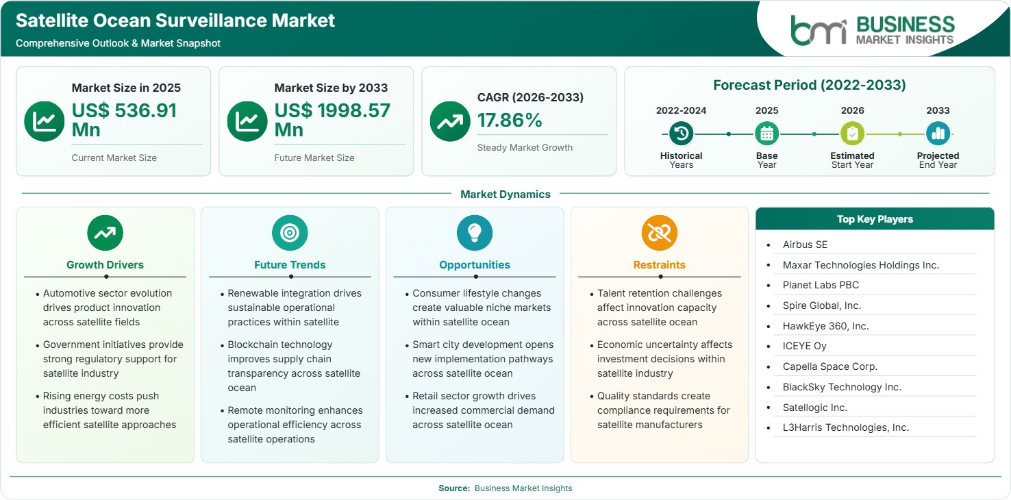
The Satellite Ocean Surveillance Market size was valued at US$ 536.91 Million in 2025 and is projected to reach US$ 1998.57 Million by 2033, growing at a CAGR of 17.86% during 2026–2033. Rising maritime security requirements, illegal fishing monitoring, sovereign surveillance investments, autonomous shipping adoption, climate intelligence needs, and expanding satellite constellations are creating substantial commercial and government opportunities.

Report Coverage
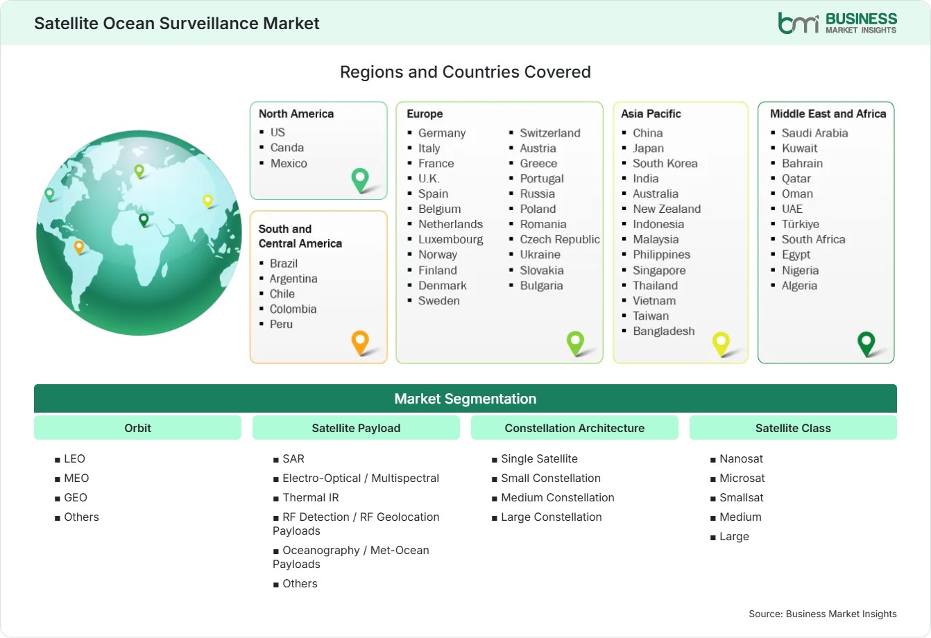
  • Orbit: LEO, MEO , GEO, Others
  • Satellite Payload: SAR , Electro-Optical / Multispectral, Thermal IR, RF Detection / RF Geolocation Payloads, Oceanography / Met-Ocean Payloads, Others
  • Constellation Architecture: Single Satellite, Small Constellation, Medium Constellation, Large Constellation
  • Satellite Class: Nanosat , Microsat , Smallsat , Medium , Large
US$ 536.91 Mn Market size in 2025
US$ 1998.57 Mn Market Size by 2033
17.86% CAGR, 2026 - 2033
2026-2033 Forecast Period

AI Overview

Satellite Ocean Surveillance Market Summary

  • North America Region: Holds a 34%–37% share in 2025, expanding at a 16.5%–18.0% CAGR during 2026–2033. Defense modernization, maritime domain awareness requirements, Arctic route monitoring, and commercial analytics investments continue accelerating adoption across public and private operators. US market benefits from government intelligence procurement and federated satellite architectures, advancing at approximately 16.8%–18.3% CAGR.
  • Fastest Growing Region: Asia Pacific accounts for 24%–27% share in 2025 and advances at 19.5%–21.5% CAGR. Maritime trade expansion, coastal security priorities, fisheries protection programs, and regional constellation investments stimulate deployment across emerging and established space economies.
  • Leading Segment: Synthetic Aperture Radar holds 30%–34% share in 2025, growing at 18.0%–20.0% CAGR. All-weather surveillance capabilities, vessel tracking efficiency, nighttime sensing advantages, and defense procurement programs sustain strong commercial and governmental demand.
  • High Growth Segment: Large Constellation holds 22%–26% share in 2025 and grows at 20.5%–22.5% CAGR. Persistent coverage expectations, reduced revisit intervals, maritime risk intelligence demand, and integrated analytics platforms support accelerated investment activity.
  • Key Market Opportunity: Integration of satellite imagery, AIS signals, radio-frequency geolocation, and AI-driven analytics creates scalable maritime intelligence platforms supporting security, shipping optimization, environmental monitoring, and blue-economy governance initiatives globally.
  • Major Market Players: Airbus SE, Maxar Technologies Holdings Inc., Planet Labs PBC, Spire Global, Inc., HawkEye 360, Inc., ICEYE Oy, Capella Space Corp., BlackSky Technology Inc., Satellogic Inc., and L3Harris Technologies, Inc.
Strategic Insights

Satellite Ocean Surveillance Market: Strategic Insights

Satellite Ocean Surveillance Market Strategic Framework
FREE PDF
Request your free sample
Request free sample
Stakeholder View

Key Takeaways

  • The value chain is increasingly integrated, with payload manufacturers, analytics vendors, cloud providers, and maritime intelligence platforms collaborating to deliver end-to-end surveillance services.
  • RF geolocation and large constellation deployments provide the strongest upside potential where persistent monitoring of shipping lanes and gray-zone activities is increasingly required.
  • AI-enabled vessel classification, anomaly detection, and multi-sensor fusion are becoming central competitive differentiators across commercial monitoring solutions.
  • Asia Pacific presents a compelling investment case due to expanding maritime trade, territorial monitoring requirements, and national space infrastructure spending.
  • Defense agencies continue using long-term procurement contracts and commercial data acquisition models, creating predictable demand for satellite operators and analytics firms.
  • Sustainability monitoring, offshore wind assessment, and marine environmental intelligence represent emerging commercial revenue opportunities beyond traditional security applications.
Geographic Outlook

Satellite Ocean Surveillance Market Regional Highlights

North America Satellite Ocean Surveillance Market

North America represents approximately 34%–37% of global demand in 2025 and is projected to expand at a CAGR of 16.5%–18.0% through 2033. The region benefits from substantial defense spending, advanced geospatial infrastructure, and strong participation from commercial space companies. The Satellite Ocean Surveillance Market share remains highest in this region because maritime security agencies increasingly depend on persistent monitoring technologies. Strong procurement programs, Arctic shipping oversight, fisheries enforcement, and integrated intelligence frameworks continue supporting regional leadership.

  • Growing defense acquisition budgets support large-scale deployment of SAR and RF monitoring capabilities across strategic maritime regions.
  • Commercial maritime intelligence platforms increasingly combine satellite data with AIS and weather datasets for operational decision-making.
  • Arctic navigation expansion drives demand for persistent monitoring, environmental assessment, and sovereign surveillance solutions.
  • Public-private partnerships accelerate analytics innovation and operational adoption within coast guards and security agencies.

US Satellite Ocean Surveillance Market

The United States contributes roughly 77%–81% of North American revenue and advances at an estimated CAGR of 16.8%–18.3%. National security priorities, commercial geospatial innovation, and intelligence-community procurement programs drive robust market activity. Federal agencies are expanding usage of commercial remote sensing products for maritime awareness, illegal activity detection, and critical infrastructure monitoring. Advanced analytics adoption further strengthens operational value creation.

  • Intelligence agencies increasingly acquire commercial satellite services rather than building exclusive proprietary capacity.
  • Maritime logistics operators leverage satellite intelligence to improve routing efficiency and risk visibility.
  • Multi-sensor fusion architectures improve vessel identification and anomaly detection accuracy.
  • Coastal resilience and environmental monitoring initiatives create incremental demand across civilian agencies.

Europe Satellite Ocean Surveillance Market

Europe has a market share of around 26% – 29% in 2025 and is expected to have a CAGR of 17.0% – 19.0%. The adoption of space-based services in Europe will be aided by maritime security cooperation, fisheries regulations, and advanced Earth observation technologies. France and Germany are still major players, but the Nordic countries adopt space-based services much faster due to Arctic monitoring projects. Space programs supported through institutional funding continue strengthening commercial demand and technological innovation.

  • European maritime agencies increasingly deploy satellite intelligence for border monitoring and environmental compliance.
  • France maintains leadership through established aerospace capabilities and government-backed space programs.
  • Nordic countries exhibit rapid adoption as northern shipping routes gain strategic significance.
  • Multi-country surveillance frameworks support broader interoperability and data-sharing initiatives.

Asia Pacific Satellite Ocean Surveillance Market

The Asia Pacific region is expected to account for 24%-27% of the market share and experience the highest growth rate, at a 19.5%-21.5% CAGR, due to its high levels of maritime trade, coastal security needs, and growth in the satellite manufacturing industry. China, Japan, and India continue to be the leading spenders in the market, while Southeast Asian countries increasingly invest in surveillance technologies. Satellite Ocean Surveillance Market share continues rising as governments seek greater maritime domain awareness.

  • Territorial waters monitoring and fisheries protection programs drive sustained procurement activity.
  • Domestic satellite manufacturing capabilities lower deployment costs and improve regional accessibility.
  • Shipping-intensive economies require persistent intelligence across major trade routes.
  • National space strategies promote constellation development and analytics ecosystem expansion.
  • Commercial operators increasingly partner with governments for surveillance service delivery.

Rest of World Satellite Ocean Surveillance Market

The rest of world accounts for 10%-13% of market share in 2025 and is predicted to grow at a CAGR of 17.5%-19.5%. The South and Central American countries are adopting surveillance technology to detect fish and illegal trafficking in their regions. The Middle East and Africa aim to protect offshore energy infrastructure and improve maritime security. Expanding sovereign space investments and international partnerships support broader adoption.

  • Brazil remains a leading adopter through environmental monitoring and coastal surveillance initiatives.
  • Gulf countries invest in maritime infrastructure protection and strategic maritime intelligence.
  • African coastal nations increasingly use satellite services to combat illegal fishing activities.
  • International funding programs support geospatial capacity development in emerging economies.
Global Market Geography
FREE PDF
Request your free sample
Request free sample
Segment Analysis

Satellite Ocean Surveillance Market Segmentation

Orbit

LEO-led deployments contribute about 48%-52% to the bottom line in 2025, with the segment ecosystem scaling at around 18.5%-20.5% CAGR. The scope of the Satellite Ocean Surveillance Market continues to grow due to low-latency observation capabilities, high revisit rates, and cost-effective constellation deployment models.

  • LEO: Supports high revisit rates and persistent vessel tracking, making it suitable for operational maritime monitoring, fisheries enforcement, and dynamic threat detection applications.
  • MEO: Balances coverage and latency requirements, supporting regional monitoring missions requiring broader operational visibility and moderate revisit performance.
  • GEO: Delivers continuous observation across wide ocean areas, supporting environmental intelligence, weather-linked maritime monitoring, and strategic communications integration.

Satellite Payload

Payload innovation plays an important role in market competitiveness, with the largest payload segment being Synthetic Aperture Radar, which accounts for 30%–34% market share in 2025 and is growing at an 18.0%–20.0% CAGR. The Satellite Ocean Surveillance Market trends indicate that multi-sensor configurations are favored.

  • Synthetic Aperture Radar: Enables all-weather and day-night vessel detection, supporting security, defense, and maritime governance missions across diverse operational conditions.
  • Electro-Optical/ Multispectral: Provides high-resolution imagery supporting port monitoring, environmental assessment, and shipping activity analysis.
  • Thermal IR: Identifies heat signatures useful for vessel tracking, offshore infrastructure monitoring, and environmental observation applications.
  • RF Detection/RF Geolocation Payloads: Detects communication emissions, improving maritime awareness where conventional tracking signals are absent.
  • Oceanography/Met-Ocean Payloads: Supports ocean condition monitoring, climate observation, and maritime safety operations.

Constellation Architecture

Large constellation-based architecture systems continue to gain relevance due to their persistent monitoring capabilities. This category accounts for about 22-26% of the market in 2025 and is growing at a 20.5-22.5% CAGR, driven by improved revisit performance and operational scalability.

  • Single Satellite: Suitable for focused missions, pilot programs, and budget-constrained deployments requiring limited coverage.
  • Small Constellation: Delivers improved temporal coverage while maintaining manageable operational complexity and cost structures.
  • Medium Constellation: Balances persistence, scalability, and economics for government and commercial monitoring programs.
  • Large Constellation: Maximizes revisit frequency, maritime intelligence value, and continuous surveillance capabilities across ocean regions.

Satellite Class

Small satellites continue to alter industry economics, even though there are various satellite classifications based on mission needs. This adoption has been facilitated by manufacturing capabilities, launch capability, and operational flexibility for surveillance purposes.

  • Nanosat (<10 kg): Enables affordable experimentation and distributed sensing strategies with rapid deployment cycles.
  • Microsat (10–100 kg): Offers strong cost-performance balance for commercial surveillance operators.
  • Smallsat (100–500 kg): Supports advanced payload integration and broader mission flexibility.
  • Medium (500–1,000 kg): Accommodates higher-capability sensors suitable for specialized maritime observation programs.
  • Large (>1,000 kg): Provides premium sensing performance and extended operational functionality for strategic missions.
Market Forces

Satellite Ocean Surveillance Market Dynamics

Key Market Drivers

Expansion of Maritime Security and Sovereignty Programs

There is a surge in government investments to enhance maritime domain awareness in the wake of illegal fishing, sanctions violations, piracy, and geopolitical conflicts that have become rampant along key sea routes. According to UNCTAD, international seaborne trade accounts for about 80% of the total volume of merchandise trade, rendering constant visibility a must. Satellite Ocean Surveillance Market growth is increasingly driven by defense modernization initiatives focused on persistent tracking and intelligence generation. Coast Guards, navies, and other such organizations are shifting their focus toward integrating cutting-edge surveillance systems that blend SAR, RF location, and optical imagery technologies. The capability to provide surveillance coverage over exclusive economic zones at a much lower cost than conventional surveillance assets is gaining traction.

Advances in Commercial SAR and RF Technologies

Commercial providers have made considerable gains in revisit frequency, imagery resolution, and signal intelligence by increasing constellation size and reducing sensor size. Synthetic aperture radar enables imaging without limitations from clouds or light availability and offers a significant advantage over conventional optical systems. Trends in the Satellite Ocean Surveillance market indicate that customers favor combined intelligence solutions over raw images. Cloud-based processing systems, AI analytics, and automated anomaly detection further increase mission efficiency. Such innovations help eliminate barriers to the adoption of these technologies by maritime agencies, insurance companies, logistics organizations, and offshore energy providers.

Growing Demand for Environmental and Resource Monitoring

Climate change, marine conservation needs, and offshore resource management initiatives have expanded the user group beyond those related to defense uses. Governments are increasingly using space-based observation capabilities to survey coastal ecosystems, pollution incidents, and fishing activities. There are more commercial opportunities driven by the need for monitoring of marine protected areas and sustainability reporting. Space-based intelligence facilitates informed decision-making within environmental authorities and ocean governance programs. The ability of space-based surveillance to cover large areas with repeated observations, together with improved analytic systems, makes it an essential part of marine resources management efforts.

Key Market Opportunities

AI-Driven Maritime Intelligence Platforms

The emergence of intelligent ecosystems results in substantial investment opportunities. The combination of satellite imaging, RF data, AIS, weather data, and analytics provides operational intelligence capabilities. Satellite Ocean Surveillance Market Forecasts account for an increase in demand for decision-making platforms rather than sensors per se. Maritime customers want automated risk assessment, route planning, and compliance systems that can analyze vast amounts of geospatial data. Providers that successfully deliver subscription-based intelligence services to their customers have the opportunity to earn recurring revenue streams while expanding addressable markets across defense, shipping, insurance, and environmental sectors.

Offshore Energy and Critical Infrastructure Monitoring

The development of offshore wind farm projects, subsea infrastructure, and ocean-based energy assets increases the need for surveillance systems. The satellite-based surveillance system will help companies identify unauthorized vessel activity, analyze operational risks, and ensure the security of their assets. Increased investment in offshore renewable energy infrastructure broadens demand beyond defense-centric purchasing. Surveillance systems providing continuous coverage and prediction have the potential to benefit from this commercial spending. Long-term energy transition strategies further strengthen the attractiveness of this opportunity across global maritime markets.

Emerging Maritime Economies and Sovereign Space Projects

Most countries along the coast have either been developing their own indigenous capabilities or forming business relationships with commercial vendors to improve their surveillance capabilities. A limited budget has prompted the use of commercially available intelligence instead of government-owned systems. There is potential for regional operators to fulfill the requirements using managed services, data subscriptions, and constellation collaboration. The growth of the digital maritime governance regime provides opportunities to enter this market, especially for fisheries and border patrol operations.

Market Restraints and Challenges

High Capital Requirements and Long Deployment Cycles

Factor: Satellite manufacturing, launch procurement, ground infrastructure development, and analytics platform deployment require substantial upfront investment. Impact: New entrants face significant financial barriers, limiting competition and slowing capacity expansion in some regions. Long development timelines can delay revenue realization and increase investor risk exposure. Although launch costs have declined, mission assurance requirements, cybersecurity obligations, and operational resilience standards continue elevating total program expenditure. Organizations evaluating adoption frequently balance surveillance benefits against budget limitations, particularly within developing economies where competing infrastructure priorities constrain procurement decisions.

Data Integration Complexity and Regulatory Constraints

Factor: Effective maritime intelligence depends on integrating multiple data sources while complying with national security, privacy, and cross-border information regulations. Impact: Interoperability challenges increase implementation complexity and operational costs. Users frequently manage disparate datasets originating from optical, SAR, RF, and AIS systems. Inconsistent standards may hinder seamless intelligence generation and delay operational deployment. Regulatory restrictions surrounding geospatial distribution and sensitive maritime information further complicate commercial service delivery. These challenges require sustained investment in cybersecurity, governance frameworks, and interoperability solutions.

Company Analysis

Competitive Landscape

Satellite Ocean Surveillance Market analysis indicates competition is increasingly centered on constellation scale, sensor diversity, analytics capability, and government contract access.

Company Name

Overview

Products and Services relevant to this market

Airbus SE

Global aerospace leader with extensive Earth observation and geospatial intelligence capabilities.

SAR data, optical imagery, maritime monitoring services, analytics and geospatial intelligence solutions.

Maxar Technologies Holdings Inc.

Leading provider of satellite imagery and space infrastructure solutions.

High-resolution imagery, maritime intelligence, geospatial analytics, mapping products.

Planet Labs PBC

Commercial earth observation operator with frequent revisit capabilities.

Satellite imagery, monitoring platforms, maritime awareness datasets and analytics.

Spire Global, Inc.

Space-based data and analytics provider serving maritime and weather sectors.

AIS tracking, vessel intelligence, maritime analytics, RF-enabled monitoring solutions.

HawkEye 360, Inc.

Specialist in radio-frequency geolocation intelligence services.

RF detection, maritime monitoring, signal tracking and situational awareness solutions.

ICEYE Oy

SAR constellation operator focused on persistent Earth observation.

SAR imagery, maritime surveillance, disaster monitoring and intelligence services.

Capella Space Corp.

Commercial SAR provider offering high-resolution monitoring capabilities.

All-weather radar imagery, vessel detection and security monitoring solutions.

BlackSky Technology Inc.

Real-time geospatial intelligence and analytics company.

Monitoring services, imagery analytics and maritime awareness products.

Satellogic Inc.

Earth observation company operating commercial imaging satellites.

High-resolution imagery and geospatial monitoring applications.

L3Harris Technologies, Inc.

Defense and intelligence technology provider with space capabilities.

ISR solutions, maritime domain awareness technologies and integrated analytics.

Trust & Transparency

Research Methodology

The market analysis combines proprietary research with secondary data from government agencies, company disclosures, regulatory filings, industry databases and expert interviews. Market estimates are validated through data triangulation, cross-market benchmarking and analyst review.

View Full Research Methodology

Questions Answered

Frequently Asked Questions

What does a Satellite Ocean Surveillance Market Report typically evaluate?

A Market Report generally assesses market size, technology developments, competition, regulations, adoption trends, regional demand patterns, and long-term industry opportunities.

What is the role of large constellations?

Large constellations reduce revisit times, improve temporal coverage, increase monitoring persistence, and enhance detection accuracy across busy maritime corridors and remote ocean regions.

How do commercial operators participate in ocean surveillance?

Commercial companies provide imagery, intelligence services, subscription analytics, and managed surveillance solutions to defense agencies, coast guards, shipping firms, and environmental organizations.

What technologies are most important in this market?

Synthetic aperture radar, RF geolocation, multispectral imaging, AI analytics, cloud processing, and vessel-tracking integration are the most influential technologies shaping market competitiveness.

Why is satellite-based ocean surveillance gaining importance?

Persistent maritime monitoring helps governments and businesses detect illegal activities, improve shipping visibility, protect offshore assets, and strengthen environmental management across vast ocean areas.

Access the Full Satellite Ocean Surveillance Market Report

Get segment-level forecasts, regional estimates, competitive benchmarking, company profiles and downloadable Excel datasets.

Access the full Satellite Ocean Surveillance Market Report
350 pages PDF & Excel | 2026-09-02
Similar Research

Related Market Reports