
Geophysical Service Market Outlook: Size, Share, Trends, Growth Analysis, Competitive Landscape & Forecast, 2026-2033

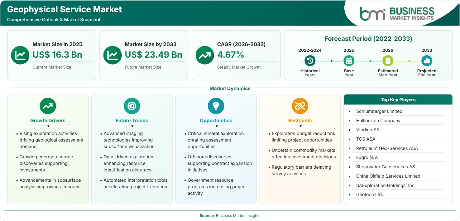
The Geophysical Service Market size was valued at US$ 16.3 Billion in 2025 and is projected to reach US$ 23.49 Billion by 2033, growing at a CAGR of 4.67% during 2026–2033, driven by subsurface imaging demand, offshore exploration, mineral discovery, digital interpretation, and carbon-storage characterization.

Report Coverage
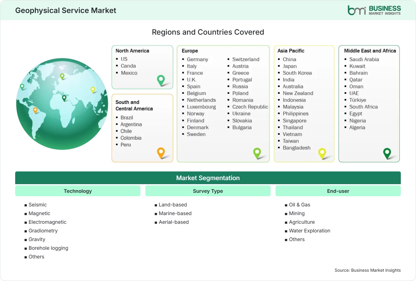
  • Technology: Seismic, Magnetic, Electromagnetic, Gradiometry, Gravity, Borehole logging, Others
  • Survey Type: Land-based, Marine-based, Aerial-based
  • End-user: Oil & Gas, Mining, Agriculture, Water Exploration, Others
US$ 16.3 Bn Market size in 2025
US$ 23.49 Bn Market Size by 2033
4.67% CAGR, 2026 - 2033
2026-2033 Forecast Period

AI Overview

Geophysical Service Market Summary

  • North America Region: North America holds a market share of 61%–64% in 2025, growing at a CAGR of 3.8%–4.4%, supported by mature oilfields, unconventional resources, mining programs, infrastructure mapping, carbon storage appraisal, and advanced digital interpretation. The U.S. remains the regional anchor, with mature shale activity, offshore development, mining exploration, and subsurface monitoring sustaining demand across seismic, logging, and electromagnetic services.
  • Fastest Growing Region: Asia Pacific holds a Geophysical Service Market share of 12%–14% in 2025, growing at a CAGR of 6.0%–6.8%, driven by offshore exploration, national seismic programs, mineral exploration, infrastructure expansion, water-resource mapping, and increasing deployment of high-density nodal technologies.
  • Leading Segment: Seismic technology holds a market share of 50%–54% in 2025, growing at a CAGR of 5.0%–5.6%, supported by high-resolution subsurface imaging, reservoir characterization, 3D and 4D surveys, offshore exploration, and expanding computational interpretation capabilities.
  • High Growth Segment: Aerial-based surveys hold a market share of 10%–13% in 2025, growing at a CAGR of 6.2%–7.0%, benefiting from rapid mineral screening, remote-area accessibility, airborne magnetic and electromagnetic mapping, shorter field campaigns, and improved spatial resolution.
  • Key Market Opportunity: Multi-physics surveys combining seismic, gravity, magnetic, electromagnetic, and borehole measurements can improve subsurface confidence while creating higher-value integrated interpretation workflows for energy, mining, water, and carbon-storage projects.
  • Major Market Players: Schlumberger Limited, Halliburton Company, Viridien SA, TGS ASA, Petroleum Geo-Services ASA, Fugro N.V., Shearwater Geoservices AS, China Oilfield Services Limited, SAExploration Holdings, Inc., and Geotech Ltd.
Strategic Insights

Geophysical Service Market: Strategic Insights

Geophysical Service Market Strategic Framework
FREE PDF
Request your free sample
Request free sample
Stakeholder View

Key Takeaways

  • The value chain is becoming more integrated, linking sensors, acquisition platforms, processing infrastructure, interpretation software, data libraries, and specialist geological expertise. Companies capable of delivering multiple stages can capture more project value and maintain longer customer relationships.
  • Seismic remains the principal revenue pool, while aerial surveys and multi-physics workflows offer stronger incremental opportunities in mineral exploration, environmental mapping, water-resource assessment, infrastructure development, and carbon-storage screening.
  • Wireless nodal systems, MEMS sensors, distributed acoustic sensing, full-waveform inversion, high-performance computing, and machine-learning workflows are improving data density and interpretation speed. Recent deployments in India demonstrate growing acceptance of cable-free and high-density acquisition architectures.
  • Asia Pacific offers the strongest expansion profile because offshore acreage development, mining investment, infrastructure construction, and national exploration programs are creating new survey requirements across multiple end-use industries.
  • Competitive positioning increasingly depends on fleet utilization, proprietary datasets, digital processing capacity, and specialized sensors rather than acquisition scale alone. Strategic capacity agreements and multi-client models are improving revenue visibility for selected contractors. Shearwater’s three-year agreement with TotalEnergies illustrates this shift.
  • Carbon capture and storage is creating a new recurring geophysical workflow because baseline characterization must be followed by monitoring and verification. Offshore storage projects therefore can generate demand beyond initial site appraisal.
Geographic Outlook

Geophysical Service Market Regional Highlights

North America Geophysical Service Market

North America accounted for a 61%–64% Geophysical Service Market share in 2025 and is estimated to expand at a 3.8%–4.4% CAGR during 2026–2033. Mature petroleum basins, unconventional development, mining exploration, infrastructure programs, and carbon-storage assessment sustain demand. The region also benefits from established service infrastructure and sophisticated interpretation capabilities. The United States remains the principal revenue contributor, while Canada supports mineral exploration, oil sands development, and environmental applications. Integrated seismic, electromagnetic, gravity, and borehole datasets increasingly support field redevelopment and subsurface risk reduction.

  • Mature shale and offshore operations sustain recurring imaging and reservoir-monitoring requirements, particularly where operators seek improved recovery from established assets.
  • U.S. demand is reinforced by mining, infrastructure, groundwater, and carbon-storage programs, creating applications beyond conventional hydrocarbon exploration.
  • Canada provides opportunities in minerals, critical-mineral exploration, oil sands, geothermal assessment, and remote-area airborne surveys.
  • Advanced computing infrastructure enables higher-resolution processing and increasingly complex inversion workflows without requiring proportional increases in field acquisition time.

US Geophysical Service Market

The U.S. accounted for about 82% - 86% of North American demand in 2025, with a forecast CAGR of 3.9% - 4.5% through 2033. Existing hydrocarbon fields continue to fuel demand for geophysical data interpretation, borehole logging, monitoring, and enhanced recovery. Mining and critical mineral exploration are also contributing to the demand for magnetic and electromagnetical surveys. Another example of demand is carbon storage, since subsurface characterization is necessary prior to and during storage operations.

  • Permian and other producing basins support recurring reservoir characterization and monitoring work, particularly where operators optimize mature assets.
  • Critical-mineral exploration increases demand for airborne magnetic, electromagnetic, gravity, and integrated geological datasets.
  • Carbon-storage projects create opportunities for baseline seismic acquisition and subsequent monitoring programs across suitable sedimentary basins.

Europe Geophysical Service Market

Europe accounted for 13% - 15% of the share in 2025 and is expected to grow at 4.1% - 4.7% CAGR from 2026 to 2033. The UK and Norway continue to be significant energy service markets driven by offshore exploration, field re-development, and reservoir monitoring services. Germany, Denmark, and the Netherlands drive demand for energy services through offshore wind power, subsurface engineering, geothermal, and carbon storage.

  • Norway maintains demand for advanced marine seismic and reservoir-monitoring services as operators extend production from mature offshore fields.
  • The United Kingdom supports 4D seismic, offshore energy infrastructure, and carbon-storage characterization, particularly around established North Sea assets.
  • Germany and Denmark broaden demand through offshore wind development, shallow subsurface mapping, geothermal projects, and environmental characterization.
  • Carbon-storage development strengthens the requirement for high-quality baseline datasets and repeat monitoring surveys across European storage sites.

Asia Pacific Geophysical Service Market

Asia-Pacific has accounted for 12%-14% of the Geophysical Service Market in 2025 and is expected to experience the highest regional expansion, with a 6.0%–6.8% CAGR from 2025 to 2033. Countries like China, Australia, and India have emerged as major hubs of demand, while Southeast Asia has opened up opportunities for offshore exploration. Australia gains from mineral exploration and energy, India gains from the country’s national seismic and offshore survey programs, while China gains from its domestic resource development.

  • India is expanding offshore and land-based acquisition, with recent projects deploying large channel counts and advanced nodal systems for complex exploration environments.
  • Australia combines strong mining demand with offshore energy and carbon-storage opportunities, supporting multi-physics and airborne survey applications.
  • China maintains demand across domestic energy, minerals, infrastructure, and marine exploration, supported by substantial national technical capabilities.
  • Southeast Asian acreage activity creates opportunities for 2D reconnaissance, 3D appraisal, reservoir monitoring, and marine geophysical acquisition.

Rest of World Geophysical Service Market

Rest of World accounted for 9%-11% in 2025 and is expected to grow at a 4.8%-5.6% CAGR till 2033. Latin America can derive benefit from its deep water exploration, mainly in Brazil and Guyana, whereas the Middle East will be led by hydrocarbons-based companies. Africa provides scope in frontier energy exploration, mining, and groundwater applications. Increasing demand is expected from high-density acquisition and interpretation, driven by the evaluation of technically challenging locations and the optimization of existing mature sites.

In Latin America, Brazil’s deep water projects and Guyana are driving growth, wherein offshore studies need high density marine acquisition technologies. In the Middle East, there is demand for land seismic and processing, whereas in Africa, there are frontier energy exploration and mining applications.

  • Brazil remains a major marine seismic market, supported by technically complex deepwater developments and large subsurface datasets.
  • Guyana is developing demand for reservoir surveillance and seismic acquisition alongside continued offshore resource development.
  • Saudi Arabia, the UAE, and Oman sustain advanced land-seismic and processing requirements across large producing basins.
  • Africa provides opportunities for airborne mineral surveys, offshore exploration, groundwater mapping, and new resource-development programs.
Global Market Geography
FREE PDF
Request your free sample
Request free sample
Segment Analysis

Geophysical Service Market Segmentation

Technology

Technology continues to be the key differentiating factor in the industry, with seismic constituting 50%-54% of the market share by 2025 and exhibiting a CAGR of 5.0%-5.6% between 2026 and 2033. Its adoption is driven by high-quality images, reservoir surveillance, and data integration and interpretation. Multi-physics approaches are becoming more common in the geophysical service market.

  • Seismic: Dominates applications requiring detailed subsurface imaging, reservoir characterization, exploration risk reduction, and repeat monitoring across onshore and offshore assets.
  • Magnetic: Supports mineral exploration and regional geological mapping by identifying magnetic contrasts associated with lithology, structures, and prospective mineralized zones.
  • Electromagnetic: Provides electrical-property information valuable for mineral exploration, groundwater studies, environmental assessment, and hydrocarbon applications where resistivity contrasts improve interpretation.
  • Gradiometry: Measures spatial variations in gravitational or magnetic fields, improving structural mapping and assisting mineral targeting across large survey areas.
  • Gravity: Supports basin-scale geological interpretation, density mapping, structural analysis, and mineral exploration, particularly where seismic acquisition is difficult or costly.
  • Borehole logging: Supplies high-resolution wellbore measurements that complement surface surveys by characterizing formation properties, fluid conditions, fractures, and reservoir boundaries.

Survey Type

The type of survey dictates the economics of acquisition, coverage, hardware needs, and resolution. Terrestrial surveys are widely used for both energy and mining exploration, while marine surveys are used for expensive offshore projects. Aerial acquisition has increased due to the preference for rapid regional screening. The Geophysical Service Market coverage now includes more versatile acquisition systems that can work in different geological areas.

  • Land-based: Remains essential for oil and gas, mining, infrastructure, water, and environmental projects where surface access permits dense acquisition and repeat monitoring.
  • Marine-based: Supports offshore exploration and reservoir monitoring using streamer, ocean-bottom node, and related technologies, with high-value projects concentrated in deepwater and frontier basins.
  • Aerial-based: Enables rapid coverage across remote or inaccessible terrain, making magnetic, electromagnetic, gravity, and hyperspectral-style workflows attractive for mineral and regional geological screening.

End-user

The diversification of end users is diminishing the reliance on traditional methods of petroleum exploration. Oil and gas will continue to account for the biggest share of the demand pool since seismic and borehole services are integral to the process of exploration, appraisal, development, and production. Mining and water exploration offer additional structural growth, and agricultural and environmental applications will help increase usage. These changes support broader opportunities for Geophysical Service Market share across nontraditional subsurface applications.

  • Oil & Gas: Remains the largest customer group, using seismic, electromagnetic, gravity, magnetic, and borehole datasets for exploration, development, reservoir management, and production optimization.
  • Mining: Uses magnetic, electromagnetic, gravity, and seismic methods to identify mineralized structures, prioritize drilling targets, and reduce exploration expenditure across large territories.
  • Agriculture: Applies geophysical measurements to characterize soil variability, groundwater conditions, drainage, salinity, and subsurface properties relevant to precision land management.
  • Water Exploration: Uses electrical, electromagnetic, seismic, and borehole techniques to identify aquifers, estimate subsurface conditions, and guide sustainable groundwater development.
Market Forces

Geophysical Service Market Dynamics

Key Market Drivers

Higher-resolution subsurface imaging is increasing survey value

There is an evolution occurring in seismic acquisition toward greater spatial density, broadband seismic, marine seabed nodes, distributed acoustic sensing, and advanced velocity model construction. Each of these advancements will help overcome limitations in conventional acquisition in areas of difficult geology, surface or subsurface features, and poor seismic signal characteristics. The Geophysical Service Market growth pattern reflects the increased demand from operators for greater assurance for each exploration dollar spent, rather than merely adding survey volume. Recent examples of nodal deployment include 12,000 WiNG nodes deployed by Sercel to the Oil and Gas Development Company in Pakistan for 3D seismic, and 3,000 WiNG 3C nodes deployed in India for 4D seismic.

Offshore resource development sustains advanced acquisition demand

Offshore exploration will remain a key source of high-priority seismic programs, as deepwater projects necessitate careful mapping before any investment in the field development is made. Geophysical Service Market trends are also shifting towards repeat seismic programs, reservoir monitoring, and multi-client programs rather than exploratory acquisitions. Recently signed contracts by Shearwater show this portfolio diversification, including projects in India, Guyana, Timor Sea, and Trinidad and Tobago. Just the India 2026 contracts bring an additional 15 months of vessels' backlog for the company.

Digital processing is compressing interpretation cycles

High-performance computing, cloud computing technologies, inversion, automated QC, and machine learning will enable extracting more subsurface information from the available data sets. It will drive Geophysical Service Market growth by making value creation migrate from acquisition to processing and interpretation. The Oman contract by Viridien is an example of this approach through proprietary imaging technology, high-resolution velocity modeling, elastic full-waveform inversion and HPC. These workflows enable operators to reinterpret existing data rather than order new surveys, thereby creating more value from the historical acquisition.

Key Market Opportunities

Carbon-storage characterization can create recurring survey demand

Carbon sequestration projects entail characterization of subsurface prior to any injection, baseline data before operations and monitoring throughout the period of storage. This results in a cycle in which services go beyond the initial exploration phase in the Geophysical Service Market forecasts. The Shearwater 2026 contract in Australia relates to conducting a 3D seismic survey in the Bonaparte Basin to assess the viability of carbon sequestration and identify future injection wells. The data is also intended to serve as a baseline for 4D monitoring.

Integrated multi-physics surveys can unlock new customer groups

The sectors of mining, groundwater, infrastructure, and the environment have needs for subsurface data that do not have the economics of petroleum exploration. By combining magnetic, gravity, electromagnetic, seismic, and borehole data acquisition, better discrimination can be achieved prior to drilling and more certainty provided. The opportunity applies to critical mineral exploration, groundwater management, geothermal development, infrastructure, and environmental applications. An integrated interpretation platform will add value through unifying these diverse data sets into a geological model. Service providers who can combine their acquisition and interpretation with application-based workflows can service smaller projects.

Data libraries and multi-client models can improve asset monetization

Acquisition under the multi-client system enables service providers to undertake surveys with the help of several clients in addition to their rights to generate revenues from data sets over a long time. This system has the potential to reduce reliance on individual exploration programs' budgets and generate recurring licensing fees. This system becomes even more pertinent when used in mature basins, since legacy seismic data can be reprocessed with advanced algorithms and then sold to fund exploration programs. The latest developments in the Eastern Mediterranean prove this point.

Market Restraints and Challenges

High acquisition costs and vessel utilization constrain project economics

Factor: Special vessel requirements, equipment costs, a trained labor force, fuel consumption, and mobilization costs are among the factors associated with marine seismic services. Impact: Profitability of contractors could come into question due to slow cycles in the contract and low utilization of vessels. Shearwater observed weak acquisition of marine contracts within the first six months of 2026 when its fleet utilization stood at 76% from 7.7 operating vessels but managed to improve backlog situation in the middle of the year. This shows how service profitability is contingent on contract cycles. The same issues apply to land contractors due to mobilization of equipment and access to terrain.

Environmental requirements can increase survey complexity

Factor: Environmental noise restrictions, permit processing, environmental impact studies, constraints imposed by the existence of marine protected areas, and local content requirements could increase preparation times and reduce acquisition opportunities. Impact: Higher compliance costs, delayed mobilization, and less flexibility could become a challenge for operators. Marine surveys have become increasingly reliant on planning in the context of the marine environment and existing facilities, while land surveys could become constrained by accessibility. The degree of regulatory complexity varies widely across countries, which calls for local expertise among service companies.

Company Analysis

Competitive Landscape

The Geophysical Service Market analysis indicates competition is increasingly based on acquisition scale, sensor technology, processing capabilities, proprietary datasets, fleet availability, geographic reach, and integrated interpretation. Leading companies are also expanding beyond conventional exploration by targeting reservoir monitoring, minerals, carbon storage, and digital subsurface workflows.

Company Name

Overview

Products and Services relevant to this market

Schlumberger Limited

Global energy technology provider with extensive subsurface capabilities and broad international operating coverage.

Seismic interpretation, electromagnetic services, borehole logging, reservoir characterization, digital subsurface workflows, and integrated geoscience solutions.

Halliburton Company

Major oilfield services provider with strong formation evaluation and wellbore technology capabilities.

Borehole logging, formation evaluation, reservoir characterization, wireline services, seismic-related interpretation, and digital subsurface technologies.

Viridien SA

Advanced Earth-data and geoscience technology company serving energy, minerals, and transition applications.

Seismic acquisition and imaging, geoscience processing, data libraries, HPC, multi-client surveys, and Earth-data interpretation.

TGS ASA

Geoscience data and technology provider with extensive subsurface datasets and interpretation capabilities.

Multi-client seismic, geophysical data, imaging, interpretation, and integrated energy and mineral geoscience solutions.

Petroleum Geo-Services ASA

Offshore geophysical specialist focused on seismic acquisition and subsurface imaging.

Marine seismic acquisition, imaging, processing, interpretation, and offshore geophysical data services.

Fugro N.V.

Global geo-data specialist serving energy, infrastructure, environmental, and natural-resource customers.

Marine and land geophysical surveys, seabed mapping, geotechnical investigation, remote sensing, and geo-data interpretation.

Shearwater Geoservices AS

Marine geoscience company specializing in high-capacity offshore seismic acquisition and processing.

2D and 3D seismic, 4D monitoring, streamer acquisition, distributed acoustic sensing, and multi-client surveys.

China Oilfield Services Limited

Integrated Chinese oilfield services company with extensive offshore exploration capabilities.

Marine seismic acquisition, geophysical data collection, well logging, drilling-related services, and offshore subsurface evaluation.

SAExploration Holdings, Inc.

Geophysical contractor focused on complex land and transition-zone acquisition projects.

Land seismic acquisition, nodal surveys, remote-area operations, geophysical field services, and data acquisition support.

Geotech Ltd.

Specialist airborne geophysical contractor with strong mineral exploration capabilities.

Airborne magnetic, electromagnetic, radiometric, and related geophysical survey services for mineral exploration.

Trust & Transparency

Research Methodology

The market analysis combines proprietary research with secondary data from government agencies, company disclosures, regulatory filings, industry databases and expert interviews. Market estimates are validated through data triangulation, cross-market benchmarking and analyst review.

View Full Research Methodology

Questions Answered

Frequently Asked Questions

How does the Geophysical Service Market report support strategic planning?

The report can support investment decisions by evaluating technology adoption, survey environments, end-user demand, regional expansion, competitive positioning, emerging applications, and the operational factors affecting acquisition and interpretation economics.

What should buyers evaluate when selecting a geophysical service provider?

Buyers should evaluate sensor performance, acquisition density, processing capability, interpretation expertise, geographic experience, environmental compliance, equipment availability, project execution history, data security, and the provider’s ability to integrate multiple geophysical datasets.

How are multi-client surveys changing service-provider economics?

Multi-client models allow providers to distribute acquisition costs across several customers and monetize datasets repeatedly. This can improve asset utilization and reduce dependence on individual exploration campaigns, particularly in established basins.

Which end-user offers the strongest long-term diversification opportunity?

Mining, carbon storage, groundwater, and infrastructure provide the strongest diversification opportunities because these applications require subsurface characterization while reducing reliance on conventional petroleum exploration budgets.

What technologies are shaping the Geophysical Service Market?

Seismic remains the core technology, but wireless nodes, MEMS sensors, distributed acoustic sensing, electromagnetic surveys, full-waveform inversion, cloud processing, and machine-learning interpretation are increasing data density and accelerating subsurface analysis.

Access the Full Geophysical Service Market Report

Get segment-level forecasts, regional estimates, competitive benchmarking, company profiles and downloadable Excel datasets.

Access the full Geophysical Service Market Report
350 pages PDF & Excel | 2026-09-18
Similar Research

Related Market Reports