
Utility Drones Market Outlook: Size, Share, Trends, Growth Analysis, Competitive Landscape & Forecast, 2026-2033

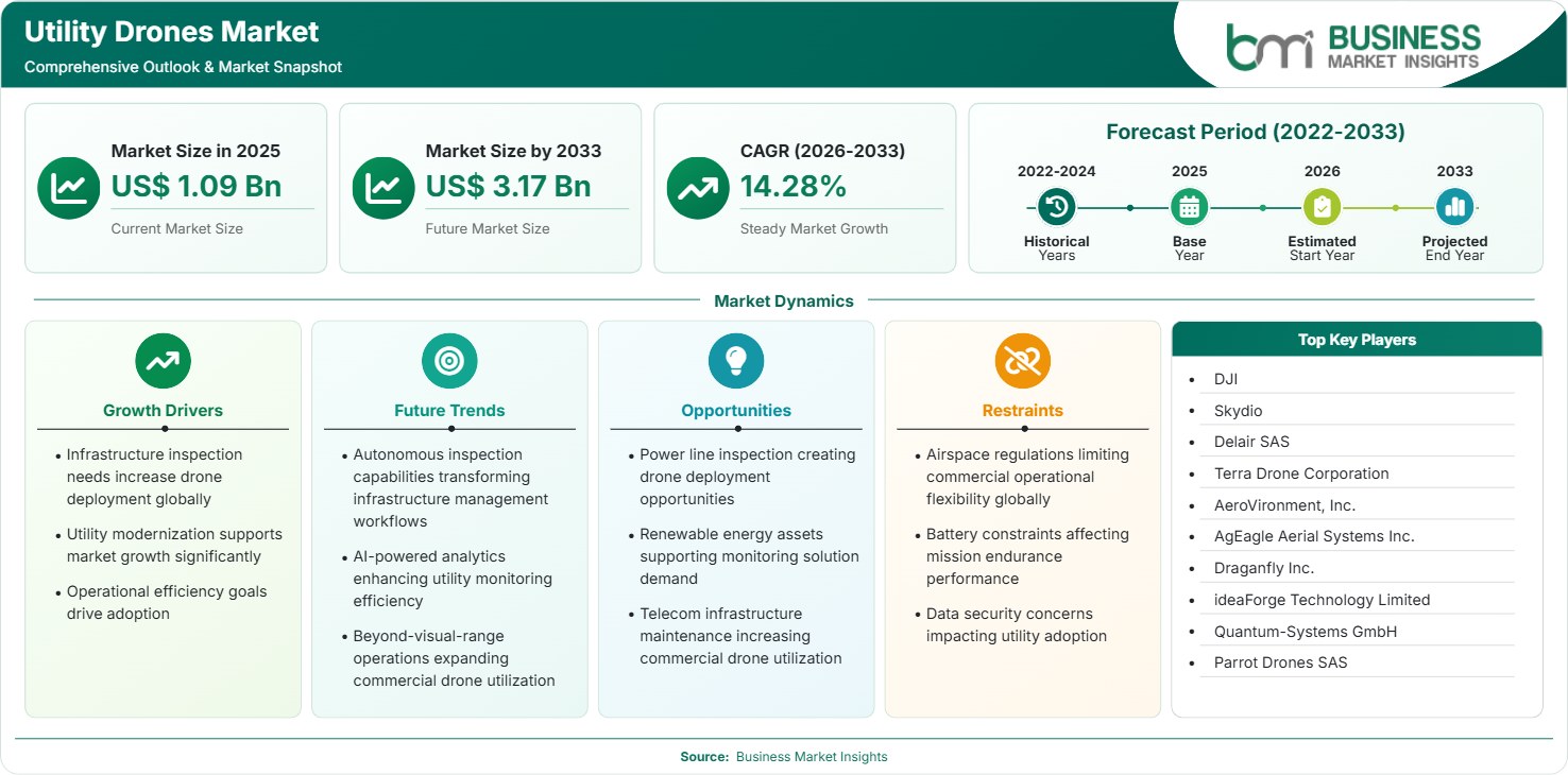
The Utility Drones Market size was valued at US$ 1.09 Billion in 2025 and is projected to reach US$ 3.17 Billion by 2033, growing at a CAGR of 14.28% during 2026–2033. Rising grid modernization investments, increasing inspection automation, renewable energy expansion, and demand for cost-efficient asset monitoring are accelerating adoption, while AI-enabled analytics and digital utility networks create new opportunities.

Report Coverage
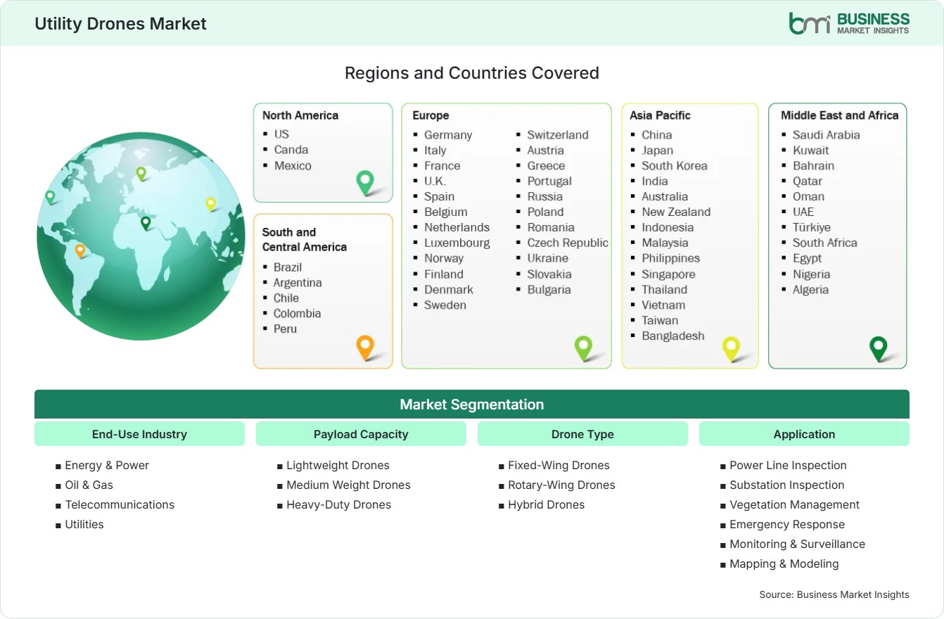
  • End-Use Industry: Energy & Power, Oil & Gas, Telecommunications, Utilities
  • Payload Capacity: Lightweight Drones, Medium Weight Drones, Heavy-Duty Drones
  • Drone Type: Fixed-Wing Drones, Rotary-Wing Drones, Hybrid Drones
  • Application: Power Line Inspection, Substation Inspection, Vegetation Management, Emergency Response, Monitoring & Surveillance, Mapping & Modeling
US$ 1.09 Bn Market size in 2025
US$ 3.17 Bn Market Size by 2033
14.28% CAGR, 2026 - 2033
2026-2033 Forecast Period

AI Overview

Utility Drones Market Summary

  • North America Region: North America holds a market share of 36%–39% in 2025, growing with a CAGR of 13.0%–14.0% during 2026–2033, driven by grid modernization programs, expanding transmission infrastructure, utility digitization initiatives, aerial inspection automation, predictive maintenance deployment, renewable energy integration, regulatory compliance requirements, wildfire mitigation investments, operational efficiency goals, and asset health monitoring advancements.
  • Fastest Growing Region: Asia Pacific accounts for 25%–28% of the Utility Drones Market share in 2025 and is projected to expand at 16.0%–17.5% CAGR during 2026–2033, supported by expanding power networks, renewable installations, telecom infrastructure development, government-backed smart grid projects, increasing industrial electrification, inspection automation demand, transmission expansion programs, and infrastructure resilience initiatives across developing economies.
  • Leading Segment: Power Line Inspection represents a 31%–34% share in 2025 and advances at 14.5%–15.5% CAGR during 2026–2033, supported by aging transmission assets, growing inspection frequency requirements, labor shortages, safety enhancement efforts, high-voltage corridor monitoring needs, data-driven maintenance strategies, utility reliability targets, operational cost reductions, and digital asset management adoption.
  • High Growth Segment: Emergency Response accounts for 12%–15% share in 2025 and expands at 17.0%–18.5% CAGR during 2026–2033, driven by climate-related infrastructure risks, disaster assessment needs, wildfire surveillance programs, rapid situational awareness requirements, utility resilience planning, emergency restoration optimization, public safety coordination, aerial intelligence capabilities, and real-time operational visibility.
  • Key Market Opportunity: AI-enabled inspection platforms integrated with drone-acquired imagery create opportunities through predictive asset maintenance, vegetation analytics, fault detection automation, utility workforce optimization, enhanced reliability management, and faster infrastructure response capabilities.
  • Major Market Players: DJI, Skydio, Delair SAS, Terra Drone Corporation, AeroVironment, Inc., AgEagle Aerial Systems Inc., Draganfly Inc., ideaForge Technology Limited, Quantum-Systems GmbH, and Parrot Drones SAS.
Strategic Insights

Utility Drones Market: Strategic Insights

Utility Drones Market Strategic Framework
FREE PDF
Request your free sample
Request free sample
Stakeholder View

Key Takeaways

  • The value chain in the industry is changing from one that focuses on hardware to one that involves integrated ecosystems incorporating sensors, AI analytics, cloud infrastructure, flight management software, and utility asset management platforms.
  • Emergency response, vegetation management, and predictive infrastructure inspection are all promising fields for growth since utilities are focusing on improving their operational resilience and readiness for extreme weather across their widely spread networks of assets.
  • Innovation is now being directed towards autonomous flight operations, the ability to operate beyond the visual line of sight, the use of thermal analytics, integrating LiDAR, and establishing digital twin connectivity to increase the accuracy of inspections and lower maintenance costs.
  • The investment environment in Asia Pacific is highly attractive because of the expansion of transmission networks, the addition of renewable energy, the introduction of smart-grid programs, and the growing trend towards electrification in both industrial and urban areas.
  • More strategic acquisitions, software partnerships, and funding are being directed towards companies that provide AI-powered analytics and those that develop autonomous flight technology to support the digital transformation of the utility sector.
  • The use of drones in inspection procedures is now becoming a necessity for utility companies that are dealing with aging infrastructure, coupled with a shortage of skilled workers and more stringent requirements regarding reliability performance.
Geographic Outlook

Utility Drones Market Regional Highlights

North America Utility Drones Market

North America is estimated to account for 34%–38% of global Utility Drones Market revenue in 2025, with a CAGR of 12%–15% during 2026–2033. The region benefits from established drone suppliers, mature electricity infrastructure, and utility investment in reliability. Aging assets, wildfire exposure, storm recovery, and workforce safety encourage adoption.

  • After experiencing extreme weather, utility companies are carrying out aerial surveys to evaluate the condition of the conductors, the closeness of the vegetation, and the state of the equipment. The consistent collection of data enables them to prioritize repairs and aids in making decisions about resilience investments in their widely spread service areas.
  • The need for frequent field visits can be reduced through the use of remote operation and automated mission planning, but this will only be adopted if operational approvals are obtained, reliable communications are ensured, safety controls are in place, and the system is integrated with current inspection procedures.
  • Drone imagery can be used for assessing vegetation and for detecting damaged equipment in areas prone to fire. Utilities may use the results of their mapping to guide ground teams to the highest-risk locations and to record the mitigation actions taken.
  • Connecting aerial imagery with asset records enhances the ability to compare inspections carried out at different times. Aircraft service providers who provide secure storage, standardized reporting, and a classification of defects that is useful in practice can distinguish their services from those of basic aircraft suppliers.

US Utility Drones Market

The United States is estimated to represent 78%–82% of North American Utility Drones Market revenue in 2025, with a CAGR of 12%–15% during 2026–2033. Adoption reflects extensive transmission and distribution networks, wildfire mitigation programs, renewable generation, and established commercial drone services.

  • Utility operators use aerial systems to inspect poles, conductors, substations, and generation facilities. The use of high-resolution and thermal imaging enables the detection of visible defects and abnormal heat patterns while reducing personnel exposure to hazardous areas.
  • Assessing the situation by air quickly after storms, fires, and outages enables operators to find out about access conditions and decide what to prioritize. Remote sensing is especially useful in cases where roads have been blocked or when damage to the infrastructure makes it unsafe to carry out ground inspections.
  • The security requirements, together with the concerns regarding sensitive infrastructure data, have an effect on the selection of both aircraft and software. Companies that provide controlled data handling, secure processing, reliable support, and open-source components may find themselves in a stronger position when bidding for regulated contracts.
  • Line-of-sight inspections can be extended, but operators have to comply with the requirements of the Federal Aviation Administration. The commercial scale-up will depend on authorized operating models, trained personnel, reliable communications, and documented risk controls.

Europe Utility Drones Market

Europe is estimated to hold 27%–31% of global Utility Drones Market revenue in 2025, with a CAGR of 13%–16% during 2026–2033. Grid modernization, renewable energy integration, and aging transmission assets support demand. France benefits from established transmission infrastructure and industrial drone expertise, while Germany offers opportunities across electricity networks and renewable facilities.

  • Centralized drone inspections can be used to carry out a consistent assessment of overhead power lines, and increased investment by utility companies in remote operations provides opportunities for the use of autonomous aircraft, secure communications, and software that turns the results of inspections into maintenance priorities.
  • Because of the existing transmission networks and the experience gained from using industrial unmanned aircraft, applications in power-line inspection, corridor mapping, and vegetation assessment are possible. Suppliers can make use of combining long-range data collection with geospatial analysis.
  • The demand for aerial surveys is supported by renewable electricity infrastructure and industrial digitization. This applies to substation condition monitoring, inspections of solar facilities, and mapping of transmission corridors, since consistent digital records help with planning.
  • The need for durable aircraft and specialized inspection services is driven by hydropower assets, the remoteness of the grids, and the difficult seasonal conditions. When making a purchase, weather tolerance, reliable navigation, and efficient mobilization are important factors to consider.
  • While common European frameworks can help to achieve coordinated development, approvals at an operational level and local restrictions still apply. Suppliers should have strong privacy practices, conduct flight-risk assessments, and implement data governance for sensitive infrastructure.

Asia Pacific Utility Drones Market

Asia Pacific is estimated to represent 25%–30% of global Utility Drones Market revenue in 2025, with a CAGR of 17%–21% during 2026–2033. Electricity demand, renewable installations, urban expansion, and telecommunications development create a broad deployment base.

  • Drone manufacturing for domestic use and large-scale electricity infrastructure projects is carried out to enable inspection and mapping activities. When bidding, suppliers base their competition on the integration of sensors, the availability of aircraft, their software capabilities, and their ability to support large-scale enterprise operations.
  • The development of power networks, the growth in renewable energy generation, and the increasing number of remote assets provide opportunities for inspection services. However, their adoption is contingent on the use of aircraft that are cost-effective, the availability of trained operators, reliable data processing, and adherence to national drone regulations.
  • The fact that the infrastructure is aging and that there are limitations regarding the workforce is a reason why repetitive inspection tasks should be automated. For utilities working in restricted environments, it is important to have small aircraft, accurate navigation, reliable imaging, and software that records the condition of the assets.
  • The need for extensive surveys is supported by long transmission corridors, energy infrastructure associated with mining, and remote substations. In cases where coverage requirements call for different flight characteristics, fixed-wing aircraft and hybrid platforms can supplement rotary-wing systems.
  • There are growing opportunities resulting from grid development, investments in telecommunications and renewable projects. When carrying out deployments in island, tropical, and mountainous areas, local partnerships, service networks, operator training, and aircraft resilience are all important.

Rest of World Utility Drones Market

South and Central America are estimated to account for 5%–8% of global Utility Drones Market revenue in 2025, with deployment supported by hydropower, long transmission corridors, and renewable generation. Brazil offers opportunities in extensive electricity infrastructure and vegetation monitoring, while Chile benefits from renewable energy and remote industrial facilities.

  • The wide extent of the hydropower and transmission infrastructure enables aerial mapping of corridors, the assessment of vegetation, and the carrying out of equipment inspections. It is necessary for providers to show that they can carry out reliable operations on different types of terrain and to combine their findings with the maintenance teams.
  • Because of the remote location of renewable energy facilities and the difficulty of the terrain involved, there is a need for mapping and inspection services. The duration that aircraft can remain in the air, the use of thermal imaging, and the availability of reliable field support all affect their suitability for use with dispersed assets.
  • Large-scale energy projects have applications in the area of substation monitoring, industrial inspection, and construction mapping. When supplying these projects, companies must meet the security requirements specific to each project and consider both high temperatures and dust exposure.
  • The need to carry out grid maintenance provides an opportunity for aerial inspections and assessments during outages. The speed at which these methods are adopted depends on deployment costs, the need to maintain continuous operations, secure handling of data, and access to trained service personnel.
  • Local operators can assist international manufacturers with matters relating to procurement, training, maintenance, and obtaining aviation permissions. In cases where utilities are unable to justify keeping large internal drone teams, service-led models may be especially effective.
Global Market Geography
FREE PDF
Request your free sample
Request free sample
Segment Analysis

Utility Drones Market Segmentation

End-Use Industry

Energy & Power is estimated to hold 38%–43% of market revenue in 2025, with a CAGR of 13%–16% during 2026–2033. Electricity transmission, distribution, generation, and renewable facilities generate recurring inspection requirements. The Utility Drones Market scope includes hardware, sensors, operational services, and associated inspection workflows.

  • Energy & Power: Utility Drones Market Demand is supported by overhead line inspection, renewable facility monitoring, substation assessment, and vegetation management. Utilities increasingly value consistent digital evidence that helps prioritize repairs, improve maintenance planning, and reduce hazardous manual inspections.
  • Oil & Gas: Drones support inspection of pipelines, storage facilities, processing sites, and remote installations. Thermal and visual sensors help document asset condition, while operating permissions and hazardous-area requirements influence aircraft selection and mission planning.
  • Telecommunications and Utilities: Aerial systems help inspect towers, supporting structures, distribution networks, and remote installations. High-resolution imagery and mapping tools improve access to difficult locations, support maintenance planning, and reduce repeated site visits.

Payload Capacity

Lightweight Drones are estimated to account for 48%–54% of Utility Drones Market revenue in 2025, with a CAGR of 14%–17% during 2026–2033. Compact platforms suit frequent visual inspections and routine field deployment.

  • Lightweight Drones: Compact aircraft are suitable for routine pole inspections, visual surveys, and rapid response. Portability and simpler deployment make them attractive to distributed field teams, although endurance and sensor capacity can limit specialized missions.
  • Medium Weight Drones: These platforms accommodate advanced cameras, thermal sensors, and selected mapping payloads. Their combination of flight performance and equipment flexibility supports more complex inspections where operators require detailed imagery without the logistical burden of larger aircraft.
  • Heavy-Duty Drones: Larger systems can carry specialized sensors or equipment for demanding industrial applications. Their use depends on payload requirements, endurance, safe operating conditions, and the economic value of collecting data in fewer missions.

Drone Type

Rotary-Wing Drones are estimated to represent 63%–68% of Utility Drones Market revenue in 2025, with a CAGR of 13%–16% during 2026–2033. Their hovering capability and maneuverability support close inspection of poles, substations, and complex structures.

  • Fixed-Wing Drones: Fixed-wing platforms suit long linear surveys, transmission corridor mapping, and broad-area vegetation assessment. Their flight characteristics support coverage-oriented missions, although conventional designs require suitable launch and recovery arrangements and are less suited to stationary close inspection.
  • Rotary-Wing Drones: Multirotor configurations can hover near equipment and capture imagery from multiple angles. Their flexibility supports substation inspection, thermal surveys, and emergency assessment, making them useful where precise positioning matters more than extensive single-flight coverage.
  • Hybrid Drones: Hybrid designs combine vertical takeoff and landing with forward-flight capability. They can address missions requiring broader coverage and flexible deployment, although higher system complexity, purchase cost, and maintenance requirements can affect adoption.

Application

Power Line Inspection is estimated to represent 32%–38% of Utility Drones Market revenue in 2025, with a CAGR of 13%–16% during 2026–2033. Utilities use aerial data to assess conductors, insulators, structures, and corridor conditions.

  • Power Line Inspection: High-resolution and thermal imagery help identify visible damage, abnormal heating, and maintenance requirements. Repeatable flight paths support comparison across inspection cycles, enabling maintenance teams to prioritize defects along extensive transmission and distribution networks.
  • Substation Inspection: Drones capture close-range imagery of transformers, insulators, connectors, and other equipment. Specialized navigation and electromagnetic resilience are valuable near energized assets, where access constraints and worker safety shape inspection procedures.
  • Vegetation Management: Aerial surveys map vegetation encroachment along power corridors and identify locations requiring trimming or further assessment. Geospatial data supports prioritization, particularly where utilities manage extensive rights-of-way or wildfire-prone infrastructure.
  • Emergency Response: Rapid deployment helps assess storm damage, fires, outages, and inaccessible sites. Aerial imagery can guide crew mobilization and restoration priorities, while operational permissions and communications determine how quickly teams can collect usable information.
  • Monitoring & Surveillance: Drones support perimeter monitoring, site security, and observation of remote infrastructure. Scheduled missions and event-triggered deployment can improve situational awareness, subject to privacy controls, cybersecurity safeguards, and applicable flight restrictions.
  • Mapping & Modeling: Photogrammetry and LiDAR can generate georeferenced maps, terrain models, and three-dimensional representations of infrastructure. These outputs support asset inventories, project planning, and change detection when data quality and coordinate systems remain consistent.
Market Forces

Utility Drones Market Dynamics

Key Market Drivers

Increasing Grid Modernization and Asset Inspection Requirements

Electricity systems need to be assessed regularly because utilities face challenges with aging equipment, additions of new equipment, and increased operational difficulty. Traditional inspections may result in much travel, difficult access, costs associated with helicopters, and human risk due to live equipment. The Utility Drones Market growth opportunity is strongest where operators convert occasional flights into standardized inspection schedules, maintain comparable records, and connect findings to asset-management systems.

AI-Based Inspection Analytics and Predictive Maintenance

Computer vision and machine learning algorithms allow software to categorize the inspection images and detect any potential defects, as well as track changes to the state of the assets over time. The thermal sensors will help detect unusual heat signatures, while the high-resolution cameras will help detect visual degradation and vegetation encroachment. Utility Drones Market trends therefore favor integrated platforms that combine reliable aircraft, repeatable data capture, traceable analytical outputs, and workflows that allow qualified inspectors to validate results before maintenance decisions are made.

Workforce Safety and Operational Efficiency

To inspect their distributed assets, utilities have to deal with the challenge of inspecting while keeping themselves safe from any height-related risk, traffic-related risks, electrical hazards, and difficult terrain. By using drones, these utilities can avoid climbing, bucket trucks, and helicopters. According to Skydio, there are a number of utility applications that include autonomous navigation, inspection imagery, and mission management. The commercial benefits of using drones for utilities would depend on the type of inspection procedure that they were following before.

Key Market Opportunities

Remote and Autonomous Drone-in-a-Box Operations

Docked aircraft that remain stationed near critical infrastructure can support scheduled inspections and rapid deployment after alerts. Remote operations may reduce travel time and enable centralized teams to oversee geographically dispersed assets, provided the operating model is authorized and communications remain reliable. National Grid's September 2025 announcement of centralized autonomous aerial inspections illustrates movement from controlled trials toward routine network operations.

Integrated Inspection Software and Recurring Service Contracts

Greater business value is possible in the utilities industry with flight data that is tied into the asset register, GIS system, work orders, and maintenance. The vendors have the chance of offering regular inspection plans and not just selling planes to the companies. Such contracts can be structured to include scheduled flights, data storage, data classification, reporting, and repeat surveys under specific service level agreements. It is beneficial for the purchaser when the vendor specifies the scope of work, data quality, reporting, and validation.

Renewable Energy and Remote Infrastructure Expansion

Development of solar farms, wind farms, hydroelectric plants, and the infrastructure that connects them offers many possibilities for aerial surveys and inspections during construction and operation phases. The drone survey can be used to assess the progress of installations, the site condition, and to spot any visual damage or obstacles. Remote pipelines, communication towers, and utilities provide another area where traditional access becomes too expensive. It allows providers to create dedicated packages for various types of assets.

Market Restraints and Challenges

Airspace Restrictions and Complex Operating Permissions

Factor: Aviation regulations may restrict flights near populated areas, airports, sensitive facilities, and beyond visual line of sight without the required authorization. Utilities often need repeatable operations over long corridors, making permissions and operating procedures central to program design. Impact: Approval delays can reduce the immediate value of autonomous inspection, increase administrative costs, and limit the number of assets covered per day.

Cybersecurity, Weather Exposure, and Data Reliability

Factor: Utility drones depend on aircraft electronics, positioning systems, communications links, batteries, sensors, and software that can be affected by weather, interference, equipment failure, or cybersecurity incidents. Sensitive imagery may also reveal the configuration and condition of critical infrastructure. Impact: Unreliable flights, compromised data, or inaccurate defect classifications can delay maintenance and undermine buyer confidence.

Company Analysis

Competitive Landscape

Utility Drones Market analysis indicates increasing competition among drone manufacturers, autonomous flight specialists, and aerial intelligence providers focused on inspection efficiency, AI analytics integration, and utility-sector digital transformation.

Company Name

Overview

Products and Services relevant to this market

DJI

Global drone manufacturer with extensive enterprise deployment across infrastructure inspection and industrial monitoring applications.

Enterprise aerial platforms, thermal imaging drones, asset inspection systems, mapping solutions, and infrastructure monitoring technologies.

Skydio

U.S.-based autonomous drone company specializing in AI-powered navigation and industrial inspection solutions.

Autonomous inspection drones, infrastructure analytics, remote asset monitoring, and utility-focused aerial intelligence solutions.

Delair SAS

French drone technology provider serving industrial, utility, and infrastructure sectors globally.

Fixed-wing inspection drones, corridor mapping solutions, utility analytics, and asset intelligence platforms.

Terra Drone Corporation

Industrial drone services company supporting infrastructure inspection and digital transformation initiatives.

Utility inspection services, drone operations, infrastructure mapping, and asset management solutions.

AeroVironment, Inc.

Aerospace and unmanned systems company addressing industrial and government applications.

Advanced unmanned aerial systems, surveillance platforms, and infrastructure intelligence capabilities.

AgEagle Aerial Systems Inc.

Developer of drone technologies, sensors, and aerial intelligence platforms serving enterprise customers.

Drone platforms, sensors, geospatial analytics, mapping services, and inspection technologies.

Draganfly Inc.

Commercial drone manufacturer offering specialized systems for industrial monitoring applications.

Utility inspection drones, thermal imaging solutions, emergency response technologies, and aerial data services.

ideaForge Technology Limited

India-based drone company focused on enterprise and infrastructure monitoring applications.

Inspection drones, mapping systems, surveillance platforms, and utility monitoring solutions.

Quantum-Systems GmbH

Provider of advanced aerial intelligence systems with strong fixed-wing and hybrid capabilities.

Long-endurance mapping drones, infrastructure inspection platforms, and geospatial intelligence solutions.

Parrot Drones SAS

European drone technology company serving commercial and industrial inspection requirements.

Enterprise drones, imaging systems, infrastructure monitoring platforms, and aerial data collection services.

Trust & Transparency

Research Methodology

The market analysis combines proprietary research with secondary data from government agencies, company disclosures, regulatory filings, industry databases and expert interviews. Market estimates are validated through data triangulation, cross-market benchmarking and analyst review.

View Full Research Methodology

Questions Answered

Frequently Asked Questions

What does the Utility Drones Market Report typically evaluate?

The Utility Drones Market Report generally examines industry size, technology trends, competitive positioning, regulatory developments, regional opportunities, application demand, end-user adoption patterns, and future revenue prospects across key market segments.

How are artificial intelligence technologies influencing industry development?

AI enhances defect detection, thermal anomaly identification, vegetation risk assessment, and predictive maintenance planning. These capabilities help utilities convert aerial inspection data into actionable operational intelligence and maintenance priorities.

Which region offers the strongest future growth potential?

Asia Pacific presents the strongest expansion opportunities due to large-scale electrification programs, transmission network development, renewable energy investments, and government-backed smart grid initiatives across major economies.

Which application generates the highest revenue within the Utility Drones Market?

Power Line Inspection represents the leading application because utilities must frequently inspect extensive transmission and distribution networks to ensure operational reliability, regulatory compliance, and effective maintenance planning.

What factors are accelerating adoption of utility inspection drones?

Key adoption drivers include grid modernization, renewable energy integration, aging transmission infrastructure, workforce safety requirements, and demand for predictive maintenance. Utilities are leveraging autonomous inspections to reduce operational costs while improving asset visibility and reliability.

Access the Full Utility Drones Market Report

Get segment-level forecasts, regional estimates, competitive benchmarking, company profiles and downloadable Excel datasets.

Access the full Utility Drones Market Report
350 pages PDF & Excel | 2026-11-03
Similar Research

Related Market Reports