
Synthetic Aperture Radar Imagery Market Outlook: Size, Share, Trends, Growth Analysis, Competitive Landscape & Forecast, 2026-2033

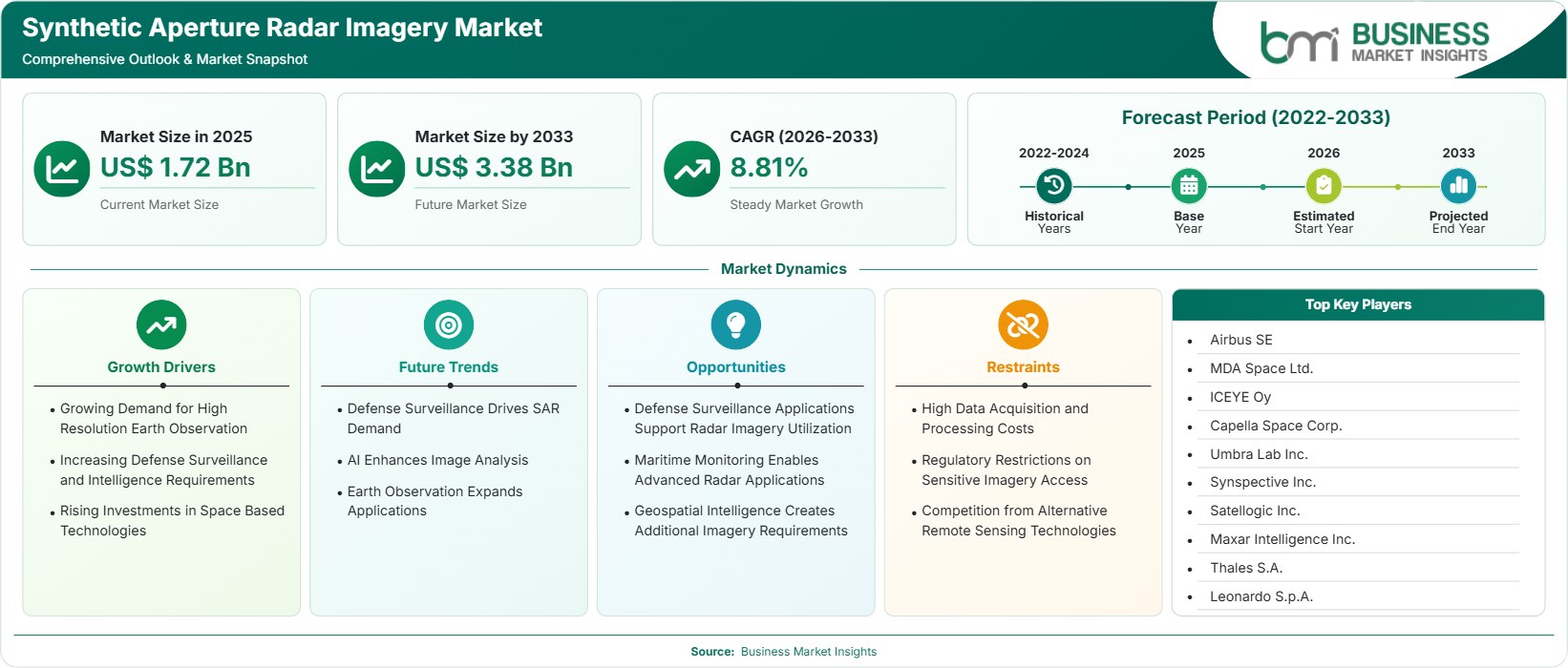
The Synthetic Aperture Radar Imagery Market size was valued at US$ 1.72 Billion in 2025 and is projected to reach US$ 3.38 Billion by 2033, growing at a CAGR of 8.81% during 2026–2033. Growth is supported by rising defense surveillance requirements, climate monitoring programs, maritime domain awareness initiatives, and expanding commercial demand for all-weather geospatial intelligence solutions.

Report Coverage
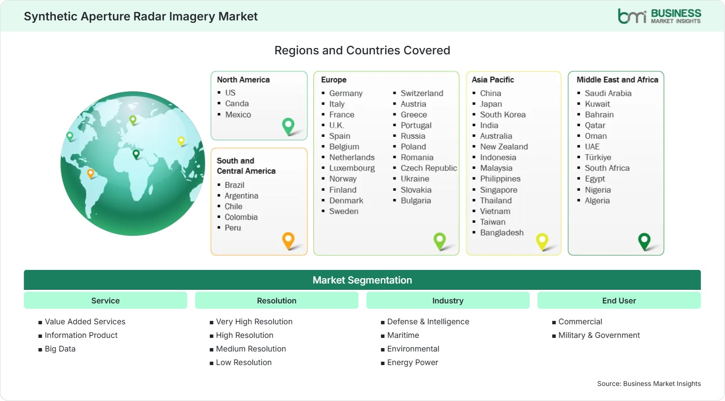
  • Service (Value Added Services , Information Product , Big Data
  • Resolution: Very High Resolution, High Resolution, Medium Resolution, Low Resolution
  • Industry: Defense & Intelligence, Maritime, Environmental, Energy Power
  • End User: Commercial, Military & Government
US$ 1.72 Bn Market size in 2025
US$ 3.38 Bn Market Size by 2033
8.81% CAGR, 2026 - 2033
2026-2033 Forecast Period

AI Overview

Synthetic Aperture Radar Imagery Market Summary

  • North America Region: Holds a market share of 36%–39% in 2025, growing at a CAGR of 8.0%–8.6% during 2026–2033. Demand is fueled by defense modernization, intelligence integration, disaster monitoring investments, commercial analytics adoption, expanding satellite constellations, government procurement programs, critical infrastructure surveillance, and advanced geospatial information requirements. US market benefits from strong government spending, commercial satellite deployment, and an estimated CAGR of 8.2%–8.8%.
  • Fastest Growing Region: Asia Pacific accounts for 24%–27% share in 2025 and advances at 10.2%–10.9% CAGR during 2026–2033. Growth stems from expanding space programs, maritime security priorities, environmental monitoring initiatives, agricultural digitization, sovereign observation capabilities, satellite investments, intelligence requirements, and increasing public-private partnerships.
  • Leading Segment: Military & Government holds a 58%–62% share of the Synthetic Aperture Radar Imagery Market in 2025 and grows at 8.5%–9.1% CAGR during 2026–2033. Persistent surveillance requirements, border monitoring, defense analytics, tactical intelligence applications, rapid decision support needs, imaging resilience, and national security priorities continue supporting segment leadership.
  • High Growth Segment: Value Added Services (VAS) records 30%–34% share in 2025 and expands at 10.1%–10.8% CAGR during 2026–2033. Demand is strengthened by analytics platforms, automated interpretation tools, cloud-based processing, enterprise integration, geospatial intelligence workflows, scalability advantages, and actionable information delivery.
  • Key Market Opportunity: Integration of artificial intelligence with radar-derived datasets enables predictive monitoring, infrastructure assessment, disaster response automation, maritime tracking, agricultural intelligence, and scalable commercial analytics across numerous industry environments worldwide.
  • Major Market Players: Airbus SE, MDA Space Ltd., ICEYE Oy, Capella Space Corp., Umbra Lab Inc., Synspective Inc., Satellogic Inc., Maxar Intelligence Inc., Thales S.A., Leonardo S.p.A.
Strategic Insights

Synthetic Aperture Radar Imagery Market: Strategic Insights

Synthetic Aperture Radar Imagery Market Strategic Framework
FREE PDF
Request your free sample
Request free sample
Stakeholder View

Key Takeaways

  • The value chain is increasingly shifting from imagery acquisition toward analytics, interpretation, and decision-support services, creating higher-margin opportunities across the ecosystem.
  • Environmental monitoring, maritime intelligence, and infrastructure inspection represent some of the most attractive commercial expansion opportunities through 2033.
  • Artificial intelligence-enabled image interpretation is reducing processing time while improving object detection, anomaly identification, and predictive intelligence outputs.
  • Asia Pacific offers a compelling investment case due to expanding space infrastructure, sovereign satellite programs, and growing national security requirements.
  • Strategic partnerships between satellite operators, cloud providers, and defense agencies are accelerating technology commercialization and platform adoption.
  • Higher-resolution sensors and increased revisit frequencies are becoming important competitive differentiators in the evolving industry landscape.
Geographic Outlook

Synthetic Aperture Radar Imagery Market Regional Highlights

North America Synthetic Aperture Radar Imagery Market

North America accounted for approximately 36%–39% of global revenue in 2025 and is projected to expand at a CAGR of 8.0%–8.6% through 2033. The region benefits from extensive defense procurement budgets, advanced satellite infrastructure, and strong private-sector participation. The Synthetic Aperture Radar Imagery Market share leadership of North America is supported by military intelligence requirements, disaster-response programs, and commercial geospatial analytics demand. Continued investments in multi-domain awareness and radar-enabled earth observation strengthen regional adoption across both government and commercial end users.

  • Defense intelligence agencies continue procuring commercial radar imagery to complement national observation assets and improve operational awareness.
  • Expanding analytics platforms accelerate conversion of imagery into actionable intelligence for enterprise and government users.
  • Satellite constellation growth improves revisit rates, increasing the value of persistent monitoring solutions.
  • Infrastructure protection and climate-resilience programs support long-term procurement of advanced geospatial services.

US Synthetic Aperture Radar Imagery Market

The United States represents approximately 72%–76% of North American revenue and advances at a CAGR of 8.2%–8.8%. Federal investments in national security, disaster response, and environmental monitoring remain primary demand generators. Advanced commercial operators, venture capital activity, and government partnerships contribute to adoption. Strong collaboration between defense agencies and commercial providers supports innovation, enabling broader utilization of radar-based geospatial intelligence across civilian and military applications.

  • Government agencies increasingly integrate commercial radar datasets into intelligence and environmental-monitoring workflows.
  • Space technology funding continues supporting deployment of next-generation satellite constellations and value-added analytics.
  • Critical infrastructure monitoring requirements expand adoption among utilities, transportation authorities, and public agencies.
  • AI-enabled processing platforms improve operational efficiency and interpretation accuracy.

Europe Synthetic Aperture Radar Imagery Market

Europe holds approximately 27%–30% share in 2025 and is expected to register a CAGR of 8.4%–9.0% through 2033. Regional demand is influenced by strategic autonomy initiatives, environmental observation requirements, and security programs. Germany and France remain leading Synthetic Aperture Radar Imagery Market players, while Finland demonstrates higher growth supported by commercial radar innovation. Public investments in earth observation and climate monitoring continue encouraging adoption across defense, environmental, and infrastructure applications.

  • European space initiatives drive continued demand for advanced observation technologies and analytics capabilities.
  • Finland emerges among the fastest-growing markets through commercial radar satellite development.
  • Environmental monitoring programs support imagery utilization for land-use, forestry, and climate assessments.
  • Maritime surveillance demand strengthens adoption across coastal and border-monitoring authorities.

Asia Pacific Synthetic Aperture Radar Imagery Market

Asia Pacific accounts for 24%–27% of the world’s income and is expected to register the highest CAGR of 10.2%–10.9%. The major market players in this region are China, Japan, and India, whereas South Korea is showing promising growth. Rising space investments, maritime security issues, and agriculture surveillance are driving the market’s development. Government emphasis on sovereignty-based observational systems encourages purchases of cutting-edge radar imaging technology for both civil and defense purposes.

  • Maritime monitoring programs support deployment of radar-derived intelligence across strategic waterways.
  • Agricultural digitization initiatives encourage broader adoption of geospatial monitoring technologies.
  • National space agencies continue expanding earth-observation programs and satellite launches.
  • South Korea and India present attractive opportunities through innovation-focused investments.
  • The region contributes significantly to overall Synthetic Aperture Radar Imagery Market growth.

Rest of World Synthetic Aperture Radar Imagery Market

Rest of World market will account for around 8% to 10% of the market share in 2025 and is forecast to register a CAGR of 8.8% to 9.5%. South & Central America are driven by agricultural and environmental monitoring applications, whereas the Middle East & Africa markets are growing due to support for security- and infrastructure-related activities. Brazil continues to be the largest market in the Latin America region, whereas Saudi Arabia & UAE show more growth potential through expanding space and geospatial intelligence investments.

  • Resource monitoring applications drive demand within mining, agriculture, and energy industries.
  • Gulf countries increase spending on space technologies and national geospatial capabilities.
  • Environmental risk assessment supports utilization across flood-prone and climate-sensitive regions.
  • Infrastructure development projects encourage use of monitoring and surveillance technologies.
Global Market Geography
FREE PDF
Request your free sample
Request free sample
Segment Analysis

Synthetic Aperture Radar Imagery Market Segmentation

Service

Service accounted for the largest value creation layer, with increasing demand for interpretable intelligence rather than raw imagery. This segment represented approximately 32%–36% of revenue in 2025 and is expected to expand at 9.4%–10.0% CAGR. The Synthetic Aperture Radar Imagery Market scope continues widening as service providers integrate analytics, cloud processing, and automated interpretation capabilities.

  • Value Added Services (VAS): Strong demand for processed insights, object detection, change analysis, and enterprise-ready intelligence continues supporting adoption across government and commercial customers.
  • Information Product (IP): Standardized geospatial products help users extract operational value without maintaining advanced internal processing infrastructure.
  • Big Data: Large-scale analytical environments integrate radar datasets with multiple information sources to improve predictive intelligence capabilities.

Resolution

Resolution-based differentiation remains an important component of competitive rivalry. This industry benefits from the increasing demand for accuracy in monitoring and intelligence generation. 25% -29% revenue share in 2025 and a constant growth rate of 8.7%-9.3% CAGR due to high-resolution imaging.

  • Very High Resolution: Preferred for tactical intelligence, urban monitoring, and infrastructure assessment requiring detailed observations.
  • High Resolution: Widely adopted across maritime surveillance, environmental assessment, and commercial intelligence applications.
  • Medium Resolution: Enables efficient monitoring over larger geographic areas while balancing cost and performance.
  • Low Resolution: Suitable for broad-area coverage and trend evaluation across extensive territories.

Industry

The specific applications across industries continue to grow as radar-based intelligence becomes more valuable. This particular industry segment accounted for approximately 28%-32% in 2025 and is expected to grow at a 9.0%-9.7% CAGR. The Synthetic Aperture Radar Imagery Market trends show a greater inclination toward industry-oriented analytics solutions.

  • Defense & Intelligence: Supports border surveillance, security operations, situational awareness, and intelligence gathering activities worldwide.
  • Maritime: Enables vessel tracking, illegal fishing detection, and coastal monitoring under all-weather conditions.
  • Environmental: Supports flood assessment, deforestation monitoring, and climate-related observations.
  • Energy & Power: Assists asset monitoring, pipeline oversight, and infrastructure risk management programs.

End-User

End-user demand will remain highly focused on government institutions, whereas commercial demand will grow rapidly. This market is estimated to hold around a 58%-62% share in 2025 and is projected to experience an 8.5%-9.1% CAGR throughout the forecast period.

  • Commercial: Increasing utilization across agriculture, insurance, infrastructure, mining, and environmental intelligence applications.
  • Military & Government: Maintains dominant demand through surveillance, reconnaissance, national security, and disaster-management requirements.
Market Forces

Synthetic Aperture Radar Imagery Market Dynamics

Key Market Drivers

Growing Demand for Persistent Defense Surveillance

Defense organizations increasingly need monitoring systems that work independently of weather conditions. The modern-day security environment places great importance on real-time intelligence, border surveillance, maritime awareness, and tactical reconnaissance. Radar operators from the private sector complement the satellite networks of several countries, providing better access and revisit rates. According to several national procurement strategies, there is a strong requirement for highly resilient geospatial intelligence solutions in North America, Europe, and the Asia-Pacific region. Political tension, protection of critical infrastructure, and multidomain operations have been contributing factors to the procurement process. This trend will further solidify the use of radar intelligence solutions across military and government stakeholders.

Expansion of Climate and Disaster Monitoring Programs

The use of radar imagery for mapping floods, detecting landslides, monitoring forests, and assessing infrastructure is becoming more common among governments and environmental groups. In contrast to optical technology, radar enables consistent observations even in adverse weather conditions. The adaptation of climate change strategies around the world includes increased expenditures on earth-observation technologies. Resilience programs, disaster preparedness plans, and environmental regulations create a need for geospatial intelligence. Radar data can be helpful in emergency management and resource allocation, making it a valuable tool for public-sector organizations seeking to manage climate-related risks and environmental challenges effectively.

Advancement of Commercial Satellite Constellations

Investment in the private sector is continually enhancing access to high-frequency satellite imagery. Revisit rates enable tracking of events such as ship movements, construction sites, energy generation, and logistics transportation. Cost reductions and advancements in satellite miniaturization have enhanced business viability. Tasking and archiving services and analysis products have encouraged nontraditional clients to utilize such satellites. Improved satellite constellation designs not only increase coverage but also enable a subscription model for businesses. Such factors encourage greater market participation and growth in different commercial applications beyond governmental needs.

Key Market Opportunities

AI-Driven Geospatial Intelligence Platforms

AI integration is enabling opportunities to turn images into intelligence through automation. Business customers are now more interested in predictions instead of pure data. Automated target recognition, anomaly detection, infrastructural assessment, and maritime behavior analysis increase effectiveness. Investments in AI-enabled analytics platforms can generate recurring revenue streams and reduce customer complexity. More digital transformation projects within the public and private sectors increase the potential demand. Long-term Synthetic Aperture Radar Imagery Market forecasts indicate significant value generation from software services built on imaging capabilities.

Infrastructure Monitoring and Digital Twin Applications

Transportation, utility, construction, and infrastructure assets now require constant observation more often. Radar-based deformation monitoring helps maintain infrastructure and reduces operational risks. Digital twin projects make it possible to use imagery with simulations and asset management systems. Owners of infrastructure are looking for observation technologies that are sufficiently scalable to monitor large territories cost-efficiently. These needs necessitate recurring observation contracts and specialized software. Smart city programs and infrastructure modernization projects further enhance commercial potential across developed and emerging economies.

Growth of Maritime Security and Blue Economy Programs

Vessel tracking, the prevention of illicit fishing, offshore infrastructure management, and coastal security are among the functions currently handled by maritime administrations. Radar imagery proves effective in difficult climatic conditions typical of major shipping lanes. The increasing offshore use of renewable energy, subsea infrastructure, and marine resource management initiatives adds to the list of operational demands. Both governments and private-sector companies are using maritime domain awareness systems that utilize radar imagery alongside other types of information. This trend creates opportunities for specialized service providers delivering intelligence-driven maritime solutions.

Market Restraints and Challenges

High Deployment and Data Processing Costs

Factor: The development, deployment, and operation of radar satellite systems require considerable investment and professional engineering effort. Impact: Expensive systems can lead to limited market access, reduced competition, and delayed adoption by price-sensitive customers. Radar systems are complex and require costly equipment, ground stations, calibration, and substantial computational resources. Companies should take into account their pricing strategy and investment possibilities. Although the economics of space launches are constantly improving, the financial issues still remain rather serious compared to software-dominated businesses. These conditions may constrain rapid expansion for smaller participants lacking access to capital and strategic partnerships.

Data Interpretation Complexity and Regulatory Constraints

Factor: Extracting business benefits from radar images sometimes requires specialized image-processing knowledge and analytical skills. Impact: Increased complexity might increase time-to-market and limit adoption within an organization. Most commercial clients have little or no experience analyzing radar imagery compared with optical imagery products. Data policies and security regulations could also affect data availability. As a result, providers make significant efforts to simplify these tasks. Overcoming the mentioned issues is crucial for further adoption beyond core defense and intelligence users.

Company Analysis

Competitive Landscape

The competitive environment is characterized by satellite operators, defense contractors, and geospatial intelligence specialists focused on imagery acquisition and advanced analytics. Current Synthetic Aperture Radar Imagery Market analysis highlights increasing competition around revisit rates, AI-enabled interpretation, and value-added information services.

Company Name

Overview

Products and Services relevant to this market

Airbus SE

Global aerospace and earth-observation leader serving government and commercial geospatial customers.

SAR imagery, earth observation services, defense intelligence solutions, analytics products.

MDA Space Ltd.

Canadian space technology company with strong radar and satellite expertise.

SAR data services, satellite systems, geoint analytics, monitoring solutions.

ICEYE Oy

Leading commercial SAR constellation operator focused on persistent monitoring.

Radar imagery, flood monitoring, maritime intelligence, analytics services.

Capella Space Corp.

US-based SAR specialist delivering high-frequency earth observation capabilities.

Tasked imagery, intelligence products, monitoring platforms, geospatial services.

Umbra Lab Inc.

Commercial radar imaging company emphasizing high-resolution observation solutions.

SAR imagery, analytics, intelligence support, monitoring applications.

Synspective Inc.

Japanese satellite operator focused on geospatial insights and monitoring.

Radar data, urban monitoring, infrastructure assessment, analytics solutions.

Satellogic Inc.

Earth observation company expanding geospatial intelligence offerings.

Satellite imagery, monitoring services, analytics integration capabilities.

Maxar Intelligence Inc.

Geospatial intelligence provider serving defense and commercial sectors.

Intelligence platforms, imagery analytics, mapping and monitoring services.

Thales S.A.

Defense technology provider with advanced radar and surveillance competencies.

Radar systems, intelligence services, surveillance and observation solutions.

Leonardo S.p.A.

Aerospace and defense company supporting security and geospatial applications.

Observation technologies, intelligence solutions, radar-enabled services.

Trust & Transparency

Research Methodology

The market analysis combines proprietary research with secondary data from government agencies, company disclosures, regulatory filings, industry databases and expert interviews. Market estimates are validated through data triangulation, cross-market benchmarking and analyst review.

View Full Research Methodology

Questions Answered

Frequently Asked Questions

What does a Synthetic Aperture Radar Imagery Market Report typically evaluate?

It examines market size, technology developments, segment performance, regional trends, competitive positioning, investment patterns, regulatory influences, and future growth opportunities affecting industry participants.

Why is Asia Pacific considered a high-opportunity region?

The region benefits from strategic space investments, expanding earth-observation programs, maritime security priorities, and increasing adoption of geospatial technologies across government and commercial sectors.

How does artificial intelligence influence market development?

AI accelerates image interpretation through automated anomaly detection, object recognition, change monitoring, and predictive analytics, enabling higher-value geospatial intelligence services and recurring software-driven revenues.

Which industries are creating the strongest commercial demand?

Maritime, energy, infrastructure, agriculture, insurance, mining, and environmental monitoring sectors are increasingly adopting radar-derived intelligence to improve operational visibility and risk management decisions.

What differentiates radar imagery from optical satellite imagery?

Radar imagery can capture observations during nighttime and through cloud cover, making it highly effective for persistent monitoring, maritime tracking, and disaster-response activities where optical systems may face environmental limitations.

Access the Full Synthetic Aperture Radar Imagery Market Report

Get segment-level forecasts, regional estimates, competitive benchmarking, company profiles and downloadable Excel datasets.

Access the full Synthetic Aperture Radar Imagery Market Report
350 pages PDF & Excel | 2026-09-04