
3D Mapping And Modeling Market Outlook: Size, Share, Trends, Growth Analysis, Competitive Landscape & Forecast, 2026-2033

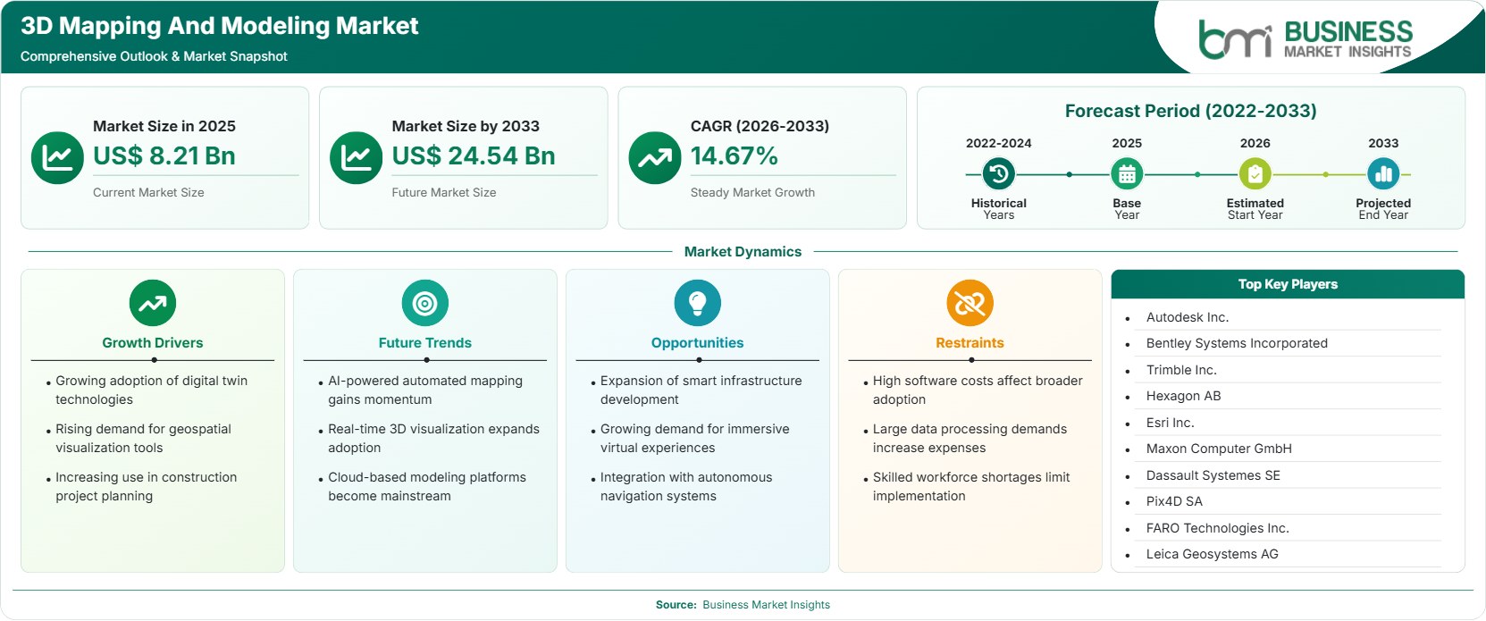
The 3D Mapping And Modeling Market size was valued at US$ 8.21 billion in 2025 and is projected to reach US$ 24.54 billion by 2033, growing at a CAGR of 14.67% during 2026–2033. Increasing adoption of digital twin solutions, growing need for geospatial visualization solutions, growing use in construction projects planning, growing investments in smart infrastructure, and constant innovations in spatial computing are driving the expansion of the market.

Report Coverage
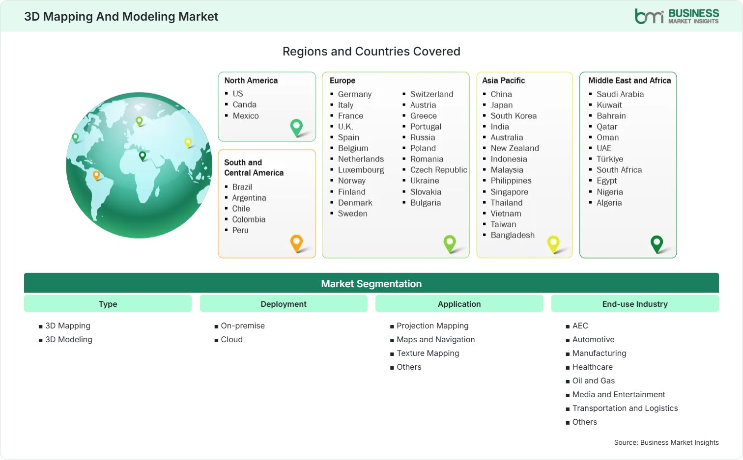
  • Type: 3D Mapping, 3D Modeling
  • Deployment: On-premise, Cloud
  • Application: Projection Mapping, Maps and Navigation, Texture Mapping, Others
  • End-use Industry: AEC, Automotive, Manufacturing, Healthcare, Oil and Gas, Media and Entertainment, Transportation and Logistics, Others
US$ 8.21 Bn Market size in 2025
US$ 24.54 Bn Market Size by 2033
14.67% CAGR, 2026 - 2033
2026-2033 Forecast Period

01 AI Overview

3D Mapping And Modeling Market Summary

  • North America Region: North America holds 36%–39% 3D mapping and modeling market share in 2025 and is projected to expand at a CAGR of 14.1%–14.6% during 2026–2033. Strong adoption of digital engineering platforms, increasing investments in smart city projects, widespread use of geospatial technologies, and continuous innovation in cloud-based visualization solutions support regional growth. The United States remains the largest contributor with an estimated CAGR of 14.2%–14.7% driven by infrastructure modernization and enterprise digital transformation.
  • Fastest Growing Region: Asia Pacific accounts for 25%–28% 3D market share in 2025 and is expected to register a CAGR of 15.8%–16.3% during 2026–2033. Expanding urbanization, increasing digital infrastructure investments, rapid industrial automation, and growing adoption of intelligent mapping technologies continue strengthening regional demand.
  • Leading Segment: 3D Modeling represents 55%–58% market share in 2025 and is anticipated to grow at a CAGR of 14.5%–15.0% during 2026–2033. Extensive deployment in engineering design, manufacturing simulation, digital asset creation, and infrastructure visualization continues supporting segment leadership.
  • High Growth Segment: Cloud deployment accounts for 47%–50% market share in 2025 and is forecast to expand at a CAGR of 16.2%–16.7% during 2026–2033. Growing enterprise migration to scalable cloud platforms, collaborative workflows, remote accessibility, and integration with artificial intelligence continue accelerating adoption.
  • Key Market Opportunity: Increasing deployment of digital twins, AI-enabled geospatial analytics, immersive visualization technologies, and intelligent infrastructure platforms is creating long-term commercial opportunities across public and private sectors.
  • Major Market Players: Autodesk Inc., Bentley Systems, Incorporated, Trimble Inc., Hexagon AB, Esri, Inc., Maxon Computer GmbH, Dassault Systèmes SE, Pix4D SA, FARO Technologies, Inc., and Leica Geosystems AG.
02 Strategic Insights

3D Mapping And Modeling Market: Strategic Insights

3d-mapping-and-modeling-market-market-strategic-framework
FREE PDF
Request your free sample
Request free sample
03 Stakeholder View

Key Takeaways

  • The industry ecosystem is becoming increasingly integrated as software developers, geospatial technology providers, hardware manufacturers, cloud service providers, and engineering firms collaborate to deliver end-to-end three-dimensional visualization and digital engineering solutions.
  • Infrastructure modernization, smart city initiatives, transportation planning, and industrial digitalization represent the strongest long-term commercial opportunities, creating sustained demand for advanced mapping and modeling technologies across both public and private sectors.
  • Innovation is rapidly shifting toward artificial intelligence-enabled automation, digital twins, cloud-native collaboration platforms, reality capture technologies, immersive visualization, and real-time geospatial analytics that improve operational efficiency and project accuracy.
  • Asia Pacific continues emerging as an attractive investment destination owing to rapid urbanization, expanding infrastructure development, increasing adoption of digital engineering technologies, and strong government support for intelligent city and transportation projects.
  • Strategic acquisitions, cloud technology partnerships, software integration agreements, and investments in artificial intelligence are enabling technology providers to expand solution capabilities while strengthening global competitiveness across diverse industry verticals.
  • The growing convergence of unmanned aerial vehicles, LiDAR scanning, Building Information Modeling, Internet of Things connectivity, and advanced visualization platforms is creating next-generation digital ecosystems capable of supporting predictive infrastructure management and autonomous operational workflows.
04 Geographic Outlook

3D Mapping And Modeling Market Regional Highlights

North America 3D Mapping And Modeling Market

North America accounted for 36%–39% of the 3D Mapping And Modeling Market Share in 2025 and is projected to expand at a CAGR of 14.1%–14.6% during 2026–2033. The region benefits from widespread adoption of Building Information Modeling (BIM), strong investments in digital engineering, advanced geospatial technologies, and increasing deployment of digital twins across infrastructure and industrial projects. Continuous innovation in cloud-based visualization platforms and enterprise software solutions further strengthens regional market leadership.

  • Engineering firms increasingly integrate three-dimensional mapping technologies into infrastructure planning, enabling higher design accuracy, improved project coordination, and efficient lifecycle asset management across public and private developments.
  • Rapid adoption of cloud computing, artificial intelligence, and reality capture technologies enables organizations to improve operational efficiency while supporting enterprise-wide digital transformation initiatives.
  • Government investments in transportation modernization, smart infrastructure, and digital city programs continue accelerating deployment of advanced geospatial mapping and modeling platforms.
  • Strong collaboration between software developers, surveying companies, and engineering organizations promotes continuous product innovation and commercial adoption across diverse industrial sectors.
  • Growing enterprise demand for digital twins, predictive asset management, and intelligent infrastructure planning continues supporting long-term regional expansion.

US 3D Mapping And Modeling Market

The United States represented 30%–33% of global revenue in 2025 and is projected to register a CAGR of 14.2%–14.7% through 2026–2033. Strong technology leadership, increasing infrastructure investments, expanding cloud adoption, and continuous innovation in geospatial software solutions maintain the country's dominant position within the global industry.

  • Construction companies increasingly adopt digital engineering platforms to optimize project planning, reduce operational risks, and improve infrastructure lifecycle management.
  • Technology providers continue expanding artificial intelligence capabilities that automate data processing, image recognition, and three-dimensional model generation for enterprise applications.
  • Federal and state infrastructure modernization initiatives continue supporting adoption of advanced mapping, surveying, and digital visualization technologies.
  • Growing use of autonomous systems, drones, and LiDAR technologies further accelerates enterprise demand for high-precision spatial data solutions.

Europe 3D Mapping And Modeling Market

Europe held 26%–29% mapping and modeling market share during 2025 and is anticipated to grow at a CAGR of 13.8%–14.3% through 2026–2033. Increasing digital construction initiatives, widespread Building Information Modeling adoption, expanding industrial automation, and strong investments in smart mobility continue supporting regional expansion. Germany leads regional demand with a CAGR of 13.9%–14.4%, while Poland records the fastest growth at 14.9%–15.4% during the forecast period.

  • Germany maintains regional leadership through advanced engineering capabilities, digital manufacturing adoption, and extensive investment in industrial automation technologies.
  • Poland experiences accelerated growth owing to infrastructure modernization, increasing construction activity, and expanding implementation of digital engineering software.
  • Growing investments in railway modernization, renewable energy projects, and urban development continue supporting demand for high-precision mapping technologies.
  • European organizations increasingly adopt cloud-enabled geospatial platforms to improve project collaboration, operational efficiency, and regulatory compliance.
  • Strong environmental planning initiatives encourage wider use of spatial analytics and digital terrain modeling across public infrastructure projects.

Asia Pacific 3D Mapping And Modeling Market

Asia Pacific accounted for 25%–28% of industry revenue in 2025 and is projected to record the highest CAGR of 15.8%–16.3% during 2026–2033. Rapid urbanization, increasing digital infrastructure investments, expanding manufacturing activities, and growing deployment of intelligent city technologies continue driving regional development. China leads regional revenue with a CAGR of 15.7%–16.2%, while India records the fastest expansion at 16.5%–17.0%.

  • China continues strengthening geospatial technology development through investments in digital infrastructure, industrial automation, and intelligent transportation systems.
  • India benefits from expanding smart city programs, rapid infrastructure development, and increasing adoption of Building Information Modeling across construction projects.
  • Japan and South Korea continue investing in advanced robotics, digital manufacturing, and artificial intelligence applications supporting three-dimensional engineering solutions.
  • Growing adoption of drone-based surveying and LiDAR technologies improves mapping efficiency while supporting infrastructure modernization across regional economies.
  • Increasing demand for immersive visualization solutions strengthens adoption across manufacturing, architecture, transportation, and public sector organizations.

Rest of World 3D Mapping And Modeling Market

The Rest of World accounted for 8%–10% market share in 2025 and is expected to register a CAGR of 14.3%–14.8% during 2026–2033. South & Central America continue adopting digital engineering technologies through infrastructure modernization and industrial development initiatives.

The Middle East & Africa are witnessing increasing implementation of smart city projects, digital infrastructure programs, and advanced surveying technologies. Brazil leads South & Central America with a CAGR of 14.4%–14.9%, while Saudi Arabia records the highest regional growth at 15.1%–15.6% due to significant investments in intelligent infrastructure and urban development.

  • Brazil continues strengthening adoption of digital mapping technologies across transportation, mining, utilities, and infrastructure planning projects.
  • Saudi Arabia accelerates deployment of three-dimensional digital engineering platforms supporting large-scale urban development and smart infrastructure initiatives.
  • Infrastructure modernization programs across emerging economies continue encouraging adoption of cloud-based mapping and visualization software.
  • Increasing investments in surveying, environmental monitoring, and industrial automation create long-term opportunities for geospatial technology providers.
  • Public-private partnerships continue supporting digital transformation across transportation, logistics, utilities, and construction industries.
global-market-geography
FREE PDF
Request your free sample
Request free sample
05 Segment Analysis

3D Mapping And Modeling Market Segmentation

Type

The Type segment accounted for 55%–58% of the market in 2025 and is projected to expand at a CAGR of 14.8%–15.2% during 2026–2033. Continuous technological innovation, growing enterprise digitalization, and expanding demand for intelligent visualization platforms continue supporting segment development. The 3D Mapping And Modeling Market Forecasts indicate sustained adoption across architecture, engineering, industrial design, manufacturing, and infrastructure planning applications.

  • 3D Mapping: Increasingly utilized for geospatial visualization, infrastructure planning, environmental monitoring, and surveying applications requiring highly accurate spatial representation and real-time geographic intelligence.
  • 3D Modeling: Maintains broad adoption across engineering, product development, digital design, manufacturing simulation, and Building Information Modeling through enhanced visualization and collaborative project workflows.

Deployment

The Deployment segment represented 52%–55% market share during 2025 and is expected to register a CAGR of 15.0%–15.5% through 2026–2033. Enterprises increasingly prioritize scalable deployment models that improve collaboration, operational flexibility, and secure data management. The 3D Mapping And Modeling Market Trends continue emphasizing cloud-native platforms capable of supporting remote engineering teams and enterprise-wide digital transformation.

  • On-premise: Preferred by organizations requiring greater control over sensitive engineering data, customized software environments, and strict regulatory compliance for mission-critical operations.
  • Cloud: Experiencing strong adoption through scalable computing resources, lower infrastructure requirements, real-time collaboration, and seamless integration with artificial intelligence and analytics platforms.

Application

The Application segment generated 49%–52% of total revenue in 2025 and is forecast to grow at a CAGR of 14.6%–15.1% during 2026–2033. Expanding digital infrastructure initiatives and increasing enterprise reliance on visualization technologies continue strengthening demand across multiple application areas.

  • Projection Mapping: Widely adopted for immersive visual experiences, architectural displays, entertainment productions, and commercial advertising requiring dynamic three-dimensional visual presentation.
  • Maps and Navigation: Supports intelligent transportation, logistics optimization, autonomous mobility, and location-based services through highly accurate geospatial information and route planning capabilities.
  • Texture Mapping: Enhances realism in engineering visualization, gaming, architecture, simulation, and digital content creation through high-quality surface representation and rendering accuracy.

End-use Industry

The End-use Industry segment accounted for 58%–61% of global revenue in 2025 and is projected to expand at a CAGR of 14.4%–14.9% through 2026–2033. Growing enterprise digitalization, infrastructure modernization, and intelligent asset management continue supporting widespread technology adoption across multiple industrial sectors.

  • AEC (Architecture, Engineering, and Construction): Continues leading adoption through Building Information Modeling, digital twins, project visualization, construction planning, and lifecycle infrastructure management.
  • Automotive: Increasingly utilizes three-dimensional visualization for vehicle design, autonomous driving development, manufacturing optimization, and virtual prototyping applications.
  • Manufacturing: Supports factory planning, digital production, equipment simulation, predictive maintenance, and operational efficiency through advanced three-dimensional engineering solutions.
  • Healthcare: Expands adoption for surgical planning, medical imaging visualization, anatomical modeling, research, and personalized treatment development.
  • Oil and Gas: Improves exploration, facility inspection, pipeline management, and infrastructure monitoring through accurate geospatial visualization and digital asset modeling.
  • Media and Entertainment: Utilizes advanced modeling technologies for animation, gaming, visual effects, immersive experiences, and digital content production.
  • Transportation and Logistics: Strengthens route optimization, infrastructure planning, warehouse visualization, fleet management, and intelligent mobility solutions through integrated spatial analytics.
06 Market Forces

3D Mapping And Modeling Market Dynamics

Key Market Drivers

Growing adoption of digital twin technologies

Digital twins are increasingly becoming commonplace in manufacturing and infrastructure sectors due to an increased need for visibility of the physical assets. Mapping and three-dimensional modeling technology offer the basis needed in creating precise digital twins that can help in various applications such as planning and maintenance. Governments and enterprises are increasingly investing in intelligent infrastructure supported by Building Information Modeling (BIM), Internet of Things (IoT), and artificial intelligence. These developments continue driving 3D Mapping And Modeling Market Growth by expanding enterprise demand for highly accurate visualization and simulation platforms.

Rising demand for geospatial visualization tools

Organizations across transportation, construction, mining, agriculture, and public administration are increasingly relying on geospatial visualization tools to improve planning accuracy and operational efficiency. Innovation in LiDAR, drone surveys, satellite imaging, and high resolution mapping provides a means for the development of accurate three dimensional spatial data. GIS integration adds to the decision-making process by enhancing infrastructure planning, environmental surveillance, disaster management, and asset tracking.

Increasing use in construction project planning

Construction companies are increasingly implementing three-dimensional mapping and modeling solutions to optimize project design, improve collaboration, reduce construction errors, and enhance resource utilization. Building Information Modeling has become an indispensable digital engineering technology for managing the lifecycle of infrastructure projects, including the design, construction, and maintenance phases. The use of advanced visualization technologies helps engineers, architects, and builders spot conflicts in design, cut down project delays, and enhance productivity in construction.

Key Market Opportunities

Expansion of smart infrastructure development

Governments worldwide continue investing in intelligent transportation systems, smart cities, digital utilities, and connected public infrastructure, creating significant opportunities for advanced mapping and modeling solutions. Three-dimensional visualization technologies support infrastructure planning, asset monitoring, and predictive maintenance while improving project execution efficiency. The 3D Mapping And Modeling Market Forecasts indicate sustained demand as public and private organizations increasingly prioritize digital infrastructure modernization supported by artificial intelligence, cloud computing, and geospatial analytics.

Growing demand for immersive virtual experiences

Increasing adoption of augmented reality, virtual reality, mixed reality, and metaverse applications is creating substantial commercial opportunities for three-dimensional modeling technologies. The industries that involve media, entertainment, education, architecture, retail, and manufacturing have been making greater investments in immersive experiences using digital technology. In order to meet their needs, the technology firms have been continuously investing in technologies that can support such requirements.

Integration with autonomous navigation systems

Autonomous vehicles, intelligent robots, drones, and advanced mobility platforms require highly accurate three-dimensional mapping for safe navigation and real-time environmental awareness. The integration of the mapping software with the use of artificial intelligence, computer vision and sensor fusion is helping to improve the ability to navigate on its own. Increased spending in the intelligent transportation systems and automation of industries will help to provide future scope for mapping software providers.

Market Restraints and Challenges

High software costs affect broader adoption

Factor: Advanced three-dimensional mapping and modeling platforms require substantial software licensing investments, specialized hardware, workforce training, and ongoing technical support. Impact: High implementation costs discourage adoption among small and medium-sized enterprises, limiting technology penetration despite increasing demand for digital engineering solutions. Budget constraints frequently delay enterprise digital transformation initiatives and reduce investment in premium visualization platforms.

Large data processing demands increase expenses

Factor: High-resolution LiDAR scans, drone imagery, satellite data, and complex three-dimensional models generate massive datasets requiring powerful computing infrastructure and advanced storage capabilities. Impact: Organizations incur significant expenses for cloud computing, data management, processing hardware, and cybersecurity, increasing total ownership costs while creating operational challenges associated with large-scale geospatial information management.

07 Company Analysis

Competitive Landscape

The competitive landscape is characterized by continuous innovation in cloud computing, artificial intelligence, geospatial analytics, and digital engineering platforms. Leading companies continue strengthening software ecosystems through strategic acquisitions, cloud integration, and intelligent automation while expanding enterprise capabilities across multiple industries. Continuous product innovation and strategic collaborations support comprehensive 3D Mapping And Modeling Market Analysis across architecture, manufacturing, transportation, infrastructure, and industrial applications.

Company Name

Overview

Products and Services Relevant to this Market

Autodesk Inc.

Global software leader specializing in engineering, architecture, manufacturing, and digital design technologies.

AutoCAD, Revit, Civil 3D, BIM solutions, digital engineering software, and cloud collaboration platforms.

Bentley Systems, Incorporated

Infrastructure engineering software provider focused on digital twins and intelligent asset management.

Infrastructure modeling software, digital twin platforms, geospatial solutions, engineering applications, and asset lifecycle management.

Trimble Inc.

Technology company delivering positioning, construction, agriculture, and geospatial solutions globally.

Surveying systems, mapping software, GNSS solutions, construction technology, and reality capture platforms.

Hexagon AB

Global provider of digital reality, measurement technologies, and industrial software solutions.

Geospatial software, digital twins, reality capture, autonomous technologies, and industrial analytics platforms.

Esri, Inc.

Leading geographic information system software developer serving government and commercial organizations.

ArcGIS platform, spatial analytics, geospatial mapping, location intelligence, and cloud GIS solutions.

Maxon Computer GmbH

Software developer specializing in professional three-dimensional modeling and animation technologies.

Three-dimensional modeling software, rendering tools, animation platforms, visualization, and digital content creation solutions.

Dassault Systèmes SE

Global software company delivering virtual design, product lifecycle management, and simulation technologies.

CATIA, SOLIDWORKS, 3DEXPERIENCE platform, digital twins, simulation, and engineering software.

Pix4D SA

Developer of drone mapping and photogrammetry software for surveying and infrastructure applications.

Drone mapping software, photogrammetry solutions, geospatial analytics, inspection platforms, and cloud processing tools.

FARO Technologies, Inc.

Measurement technology company specializing in three-dimensional imaging and digital reality solutions.

Laser scanners, metrology systems, reality capture, digital inspection, and three-dimensional measurement technologies.

Leica Geosystems AG

Global provider of surveying, positioning, and geospatial measurement technologies.

GNSS systems, laser scanners, reality capture, surveying instruments, mapping software, and digital construction solutions.

10 Trust & Transparency

Research Methodology

The market analysis combines proprietary research with secondary data from government agencies, company disclosures, regulatory filings, industry databases and expert interviews. Market estimates are validated through data triangulation, cross-market benchmarking and analyst review.

View Full Research Methodology

11 Questions Answered

Frequently Asked Questions

What does the 3D Mapping And Modeling Market Report include?

The Market Report provides comprehensive insights into market size, segmentation, competitive landscape, regional performance, technology developments, growth drivers, opportunities, restraints, recent developments, and future industry outlook.

Which industry offers the greatest long-term opportunity?

The Architecture, Engineering, and Construction industry presents the strongest long-term opportunity owing to increasing adoption of Building Information Modeling, digital twins, infrastructure modernization, and lifecycle asset management technologies.

Which deployment model is expected to grow the fastest?

Cloud deployment is projected to witness the fastest growth because it provides scalability, real-time collaboration, reduced infrastructure costs, seamless software updates, and easier integration with artificial intelligence and advanced analytics platforms.

Which region dominates the 3D Mapping And Modeling Market?

North America leads the market due to strong digital infrastructure, advanced engineering capabilities, widespread enterprise software adoption, and significant investments in smart cities, transportation modernization, and intelligent infrastructure projects.

What factors are driving the Market?

Growing adoption of digital twins, increasing demand for geospatial visualization, expanding infrastructure modernization projects, widespread Building Information Modeling implementation, and continuous advances in artificial intelligence and cloud computing are driving market growth.

Access the Full 3D Mapping And Modeling Market Report

Get segment-level forecasts, regional estimates, competitive benchmarking, company profiles and downloadable Excel datasets.

Access the full 3D Mapping And Modeling Market Report
350 pages PDF & Excel | 2026-08-05