
Remote Sensing Services Market Outlook: Size, Share, Trends, Growth Analysis, Competitive Landscape & Forecast, 2026-2033

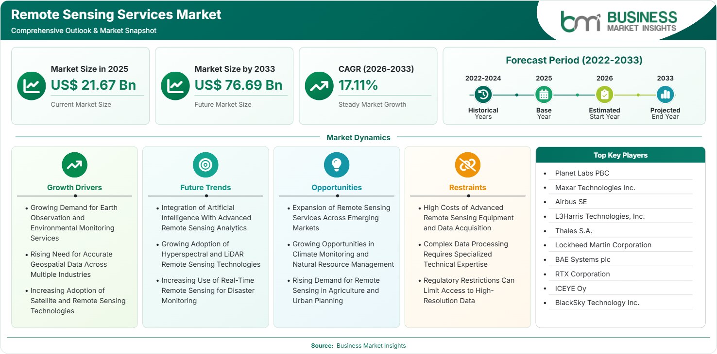
The Remote Sensing Services Market size was valued at US$ 21.67 Billion in 2025 and is projected to reach US$ 76.69 Billion by 2033, growing at a CAGR of 17.11% during 2026–2033, driven by demand for Earth observation, geospatial intelligence, environmental monitoring, precision agriculture, climate analysis, and infrastructure planning.

Report Coverage
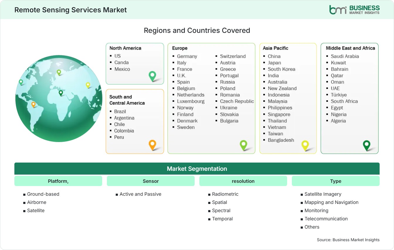
  • Platform,: Ground-based, Airborne, Satellite
  • Sensor: Active and Passive
  • resolution: Radiometric, Spatial, Spectral, Temporal
  • Type: Satellite Imagery, Mapping and Navigation, Monitoring, Telecommunication, Others
  • Application: Agriculture, Water Resources, Forest and Ecosystem, Disaster Management, Infrastructure Development, Atmospheric, Oceanic sciences, Others
US$ 21.67 Bn Market size in 2025
US$ 76.69 Bn Market Size by 2033
17.11% CAGR, 2026 - 2033
2026-2033 Forecast Period

AI Overview

Remote Sensing Services Market Summary

  • North America Region: North America accounted for a 34%–38% share in 2025 and is projected to grow at a 15.0%–17.0% CAGR during 2026–2033, supported by government Earth observation programs, and increasing demand for high-resolution data. The US market is projected to grow at a 15.5%–17.5% CAGR through 2033, supported by defense intelligence, and expanding commercial satellite capabilities.
  • Fastest Growing Region: Asia Pacific represented a 22%–26% of global remote sensing services market share in 2025 and is projected to expand at an 18.0%–21.0% CAGR through 2033, driven by rapid urbanization, agricultural monitoring, disaster management, infrastructure development, expanding satellite programs, and increasing adoption of geospatial intelligence across emerging economies.
  • Leading Segment: Platform, Satellite represented a 48%–52% share in 2025 and is projected to grow at a 16.0%–18.0% CAGR through 2033, supported by expanding satellite constellations, and increasingly accessible geospatial data services.
  • High Growth Segment: Application, Agriculture represented a 17%–21% share in 2025 and is projected to grow at an 18.0%–21.0% CAGR through 2033, driven by precision farming, crop monitoring, and increasing demand for data-driven agricultural decision-making.
  • Key Market Opportunity: Climate intelligence, natural resource monitoring, precision agriculture, urban development, and disaster response are creating opportunities for service providers to combine high-resolution imagery, analytics, AI, and real-time geospatial intelligence.
  • Major Market Players: Planet Labs PBC, Maxar Technologies Inc., Airbus SE, L3Harris Technologies, Inc., Thales S.A., Lockheed Martin Corporation, BAE Systems plc, RTX Corporation, ICEYE Oy, and BlackSky Technology Inc.
Strategic Insights

Remote Sensing Services Market: Strategic Insights

Remote Sensing Services Market Strategic Framework
FREE PDF
Request your free sample
Request free sample
Stakeholder View

Key Takeaways

  • The ecosystem increasingly connects satellite operators, sensor manufacturers, launch providers, data processors, cloud platforms, geospatial analytics companies creating an integrated value chain.
  • Agriculture, climate monitoring, disaster management, infrastructure development, and natural resource management offer strong growth opportunities as organizations increasingly use geospatial intelligence,
  • Innovation is shifting toward high-revisit satellite constellations, synthetic aperture radar, hyperspectral sensing, AI-powered analytics, automated change detection, and cloud-native processing that convert large imagery datasets into actionable intelligence.
  • Asia Pacific provides a compelling investment opportunity as governments and commercial users increase spending on satellite infrastructure, precision agriculture, smart cities, disaster preparedness, and environmental monitoring capabilities.
  • Strategic investments, partnerships, acquisitions, and commercial satellite constellation development are reshaping the competitive environment as companies seek stronger positions across imagery acquisition, analytics, cloud platforms, and specialized geospatial applications.
  • Service providers that combine high-quality data with automated analytics, industry-specific workflows, and recurring subscription models can improve customer retention.
Geographic Outlook

Remote Sensing Services Market Regional Highlights

North America Remote Sensing Services Market

North America remote sensing services market held a 34%–38% share in 2025 and is projected to grow at a 15.0%–17.0% CAGR through 2033. The region benefits from mature aerospace capabilities, established defense demand, commercial satellite investment, and advanced geospatial analytics. The US dominates regional activity through government programs and private-sector innovation.

  • The US remains the dominant regional market as defense intelligence, infrastructure monitoring, agriculture, environmental analysis, and commercial geospatial applications generate sustained demand for remote sensing services.
  • Defense and intelligence organizations continue adopting advanced sensing technologies, including radar and multispectral systems, to strengthen surveillance, situational awareness, and strategic decision-making capabilities.
  • Canada offers opportunities through forest monitoring, climate research, natural resource management, Arctic observation, and environmental applications requiring persistent coverage across challenging geographic areas.

US Remote Sensing Services Market

The US remote sensing services market represented approximately 89%–93% of North American demand in 2025 and is projected to grow at a 15.5%–17.5% CAGR through 2033. Government and defense requirements remain significant, while commercial applications are expanding across agriculture, infrastructure, insurance, logistics, and environmental monitoring.

  • Federal agencies remain major users of remote sensing data for Earth observation, defense intelligence, environmental monitoring, disaster response, and infrastructure assessment across diverse geographic regions.
  • Commercial demand is expanding as enterprises use geospatial data to monitor assets, assess environmental risks, optimize operations, and support strategic planning and investment decisions.
  • AI-powered analytics are increasing the value of imagery by automating object detection, and monitoring tasks that previously required extensive manual interpretation.

Europe Remote Sensing Services Market

Europe accounted for a 27%–31% share in 2025 and Europe remote sensing services market forecast to grow at a 14.0%–16.5% CAGR through 2033. Germany, France, the United Kingdom, Italy, and Spain represent leading markets supported by aerospace expertise and environmental applications. Germany is projected to grow at a 14.5%–16.5% CAGR, while Spain offers high-growth potential through climate monitoring and agricultural applications.

  • Germany remains a leading market due to advanced industrial capabilities, environmental monitoring requirements, infrastructure planning, and strong demand for geospatial intelligence across commercial applications.
  • France benefits from aerospace expertise and established Earth observation capabilities, supporting demand across defense, environmental analysis, agriculture, and scientific research applications.
  • The United Kingdom provides opportunities through defense intelligence, climate monitoring, infrastructure assessment, and commercial geospatial analytics.
  • Spain and Italy offer growth opportunities through precision agriculture, water management, wildfire monitoring, coastal observation, and climate resilience initiatives requiring frequent geospatial data.

Asia Pacific Remote Sensing Services Market

Asia Pacific remote sensing services market held a 22%–26% share in 2025 and is projected to achieve an 18.0%–21.0% CAGR through 2033, making it the fastest-growing region. China, Japan, India, Australia, and South Korea represent major markets, while India is projected to grow at a 19.0%–22.0% CAGR.

  • China represents a major market supported by extensive satellite capabilities, urban development requirements, agricultural monitoring, environmental observation, and growing demand for geospatial intelligence.
  • India provides a high-growth opportunity as government programs, agricultural modernization, infrastructure development, disaster management, and expanding commercial space capabilities increase demand for remote sensing services.
  • Japan benefits from advanced technology capabilities and strong requirements for disaster monitoring, infrastructure assessment, environmental observation, and precision mapping across densely developed areas.
  • Southeast Asian markets are increasingly adopting geospatial technologies for urban planning, climate resilience, agricultural monitoring, and disaster preparedness as digital infrastructure and satellite data accessibility improve.

Rest of World Remote Sensing Services Market

South and Central America remote sensing services market accounted for a 7%–9% share in 2025 and is projected to grow at a 15.0%–18.0% CAGR through 2033. Brazil and Mexico lead regional demand, supported by agricultural monitoring, and disaster management. The Middle East and Africa represented a 6%–8% share in 2025 and is projected to grow at a 16.0%–19.0% CAGR through 2033.

  • Brazil remains a major market as agricultural monitoring, Amazon forest observation, environmental compliance, and natural resource management create sustained demand for satellite imagery and geospatial analytics.
  • Mexico offers opportunities through urban planning, agricultural intelligence, infrastructure monitoring, disaster management, and environmental applications requiring accurate and frequently updated geographic information.
  • Saudi Arabia and the United Arab Emirates are expanding geospatial capabilities through smart city initiatives, infrastructure development, environmental monitoring, and strategic investments in space technologies.
  • South Africa represents an important African market as agriculture, mining, environmental monitoring, disaster preparedness, and infrastructure planning increase demand for advanced remote sensing services.
  • Latin American and Middle Eastern markets provide opportunities for providers offering affordable cloud-based imagery, specialized analytics, local partnerships.
Global Market Geography
FREE PDF
Request your free sample
Request free sample
Segment Analysis

Remote Sensing Services Market Segmentation

Platform

Satellite platforms represented a 48%–52% of remote sensing services market share in 2025 and are projected to grow at a 16.0%–18.0% CAGR during 2026–2033. Satellite-based services benefit from broad geographic coverage, increasing revisit frequency, and expanding commercial constellations.

  • Ground-based: Ground-based sensing supports localized measurements and validation activities, complementing aerial and satellite observations. Its use remains relevant for environmental research, infrastructure assessment, and sensor calibration.
  • Airborne: Airborne platforms provide high-resolution data across targeted geographic areas and support mapping, infrastructure inspection, environmental assessment, and emergency response where detailed localized observations are required.
  • Satellite: Satellite platforms provide extensive geographic coverage and increasingly frequent observations, supporting agriculture, climate monitoring, defense, disaster management, environmental analysis, and commercial geospatial intelligence applications.

Sensor

Passive sensors represented a 62%–66% of global remote sensing services market share in 2025 and are projected to grow at a 16.0%–18.0% CAGR during 2026–2033. Passive technologies remain widely used for optical and multispectral observation, while active sensors are gaining importance where imaging is required under challenging weather or lighting conditions.

  • Active: Active sensors emit energy and measure reflected signals, enabling applications such as radar imaging and topographic analysis. Their ability to operate in varied conditions supports defense and environmental monitoring.
  • Passive: Passive sensors measure naturally available radiation and are widely used for optical, multispectral, and hyperspectral observations across agriculture, environmental monitoring, mapping, and Earth science applications.

Resolution

Spatial resolution represented a 34%–38% of remote sensing services market share in 2025 and is projected to grow at a 16.0%–18.0% CAGR during 2026–2033. High-resolution spatial data remains important for mapping, infrastructure monitoring, defense, and urban planning.

  • Radiometric: Radiometric resolution determines sensitivity to differences in energy levels and supports applications requiring detailed measurement of surface characteristics, environmental conditions, and subtle changes.
  • Spatial: Spatial resolution determines the level of geographic detail captured and is critical for infrastructure monitoring, mapping, urban planning, agriculture, and defense intelligence applications.
  • Spectral: Spectral resolution enables differentiation of materials and surface characteristics across wavelengths, supporting vegetation analysis, mineral identification, environmental assessment, and advanced agricultural monitoring.
  • Temporal: Temporal resolution determines observation frequency and is increasingly important for tracking rapidly changing conditions, including crop development, disasters, environmental events, and infrastructure changes.

Type

Satellite Imagery represented a 31%–35% share in 2025 and is projected to grow at a 16.0%–18.0% CAGR during 2026–2033. Demand is supported by expanding commercial satellite constellations and increasing requirements for high-frequency geographic observation.

  • Satellite Imagery: Satellite imagery provides scalable geographic observation for agriculture, defense, infrastructure, climate analysis, environmental monitoring, and disaster response, with commercial constellations improving data availability.
  • Mapping and Navigation: Mapping and navigation services use geospatial data to support location intelligence, infrastructure planning, transportation, surveying, and digital mapping across public and commercial applications.
  • Monitoring: Monitoring services track environmental, agricultural, infrastructure, and geographic changes over time, enabling organizations to identify risks and support operational decision-making.
  • Telecommunication: Remote sensing supports telecommunications through geographic analysis, infrastructure planning, network development, and assessment of locations where connectivity infrastructure requires accurate spatial information.

Application

Agriculture represented a 17%–21% share in 2025 and is projected to grow at an 18.0%–21.0% CAGR during 2026–2033. Precision agriculture is increasing demand for crop monitoring, yield estimation, soil assessment, and water management.

  • Agriculture: Remote sensing supports crop health monitoring, yield forecasting, irrigation planning, soil assessment, and precision farming by providing repeated observations across large agricultural areas.
  • Water Resources: Satellite and airborne observations help monitor water availability, reservoirs, drought conditions, flooding, and watershed changes, supporting resource planning and climate adaptation strategies.
  • Forest and Ecosystem: Remote sensing enables forest inventory, deforestation monitoring, ecosystem assessment, biodiversity analysis, and carbon-related observation across geographically extensive and difficult-to-access environments.
  • Disaster Management: Frequent imagery supports disaster preparedness and response by identifying flood extent, wildfire impacts, infrastructure damage, and changing conditions following major natural events.
  • Infrastructure Development: Geospatial data supports site selection, construction monitoring, urban expansion analysis, infrastructure inspection, and planning of transportation and utility networks.
  • Atmospheric: Atmospheric remote sensing provides data for air quality analysis, weather observation, climate research, and monitoring of atmospheric composition and environmental changes.
  • Oceanic sciences and others: Remote sensing supports ocean observation, coastal monitoring, marine ecosystem analysis, resource assessment, and scientific research requiring broad geographic coverage and repeated measurements.

End User

Government represented a 41%–45% share in 2025 and is projected to grow at a 15.0%–17.0% CAGR during 2026–2033. Government agencies remain major users for Earth observation, environmental monitoring, mapping, disaster response, and infrastructure planning.

  • Government: Government agencies use remote sensing for environmental monitoring, land management, mapping, disaster response, infrastructure planning, and public policy development requiring accurate geographic information.
  • Military & Defense: Defense organizations use remote sensing for intelligence, surveillance, reconnaissance, strategic monitoring, terrain analysis, and situational awareness across complex operating environments.
  • Commercial: Commercial users increasingly adopt remote sensing for agriculture, insurance, mining, infrastructure, logistics, environmental risk assessment, and business intelligence supported by geospatial analytics.
Market Forces

Remote Sensing Services Market Dynamics

Key Market Drivers

Growing Demand for Earth Observation and Environmental Monitoring Services

The growing need to understand environmental changes, climate risks, land usage, and the status of natural resources is leading to higher demand for Earth observation services. The government organizations, academic institutions, environmental agencies, and commercial organizations are increasingly resorting to satellite and airborne data for monitoring the forests, water sources, agriculture areas, coastlines, and environmental systems. Frequent monitoring enables organizations to notice changes sooner and adopt an evidence-based approach in their planning. Climate adaptation projects are rising demand for continuous monitoring of vulnerable regions and environmental systems.

Rising Need for Accurate Geospatial Data Across Multiple Industries

Geospatial data is increasingly used by organizations across agriculture, infrastructure, logistics, mining, insurance, energy, and urban planning to improve decision-making. Remote sensing can provide observations over large areas, which can be used for monitoring assets, assessing land, evaluating risks, and planning operations without conducting extensive physical surveys. There have been advancements in image resolution and sensor technology, making geospatial data more detailed and available for business purposes, while cloud platforms are making it easier to access the information.

Increasing Adoption of Satellite and Remote Sensing Technologies

Satellite technology is becoming more accessible due to increased constellation launches in the commercial sector as well as decreasing launch costs in comparison to what was seen before in the marketplace. The increasing number of satellites means that more regular observations can be made possible by these satellites which allows users to track dynamic events taking place on Earth with more regularity. The combination of advanced sensing, improved data availability considered to be major remote sensing services market trend.

Key Market Opportunities

Expansion of Remote Sensing Services Across Emerging Markets

The emerging economies present a significant opportunity, as governments and commercial consumers are making considerable investments in infrastructure, agricultural improvements, disaster mitigation, environmental protection, and urban development. There are many economies with large areas where traditional surveying is expensive and difficult to perform, making the use of satellite observations very important. The capacity of local services can help adapt global images to specific local needs, regulatory requirements, and business processes. Companies that form relationships with agricultural bodies, infrastructure builders, environmentalists, and technologists can develop sustainable demand.

Growing Opportunities in Climate Monitoring and Natural Resource Management

Climate change and resource scarcity are driving greater demands for reliable forest monitoring, water monitoring, agriculture land monitoring, coastal monitoring, and ecosystem monitoring. Remote sensing technology offers continuous monitoring capabilities over large geographic areas, enabling analysis of environmental changes and allowing organizations to discover potential threats. Governments and firms have increasing needs for information that will help them to plan for climate resilience, monitor carbon dioxide emissions, manage water supplies, and implement conservation programs. The rise of environmental accountability and environmental reporting will motivate companies to utilize geospatial data from independent sources to monitor their performance.

Rising Demand for Remote Sensing in Agriculture and Urban Planning

Agriculture and urban planning are emerging as major commercial opportunities because both sectors require frequent, scalable geographic information. Farmers and agricultural organizations can use remote sensing to monitor crop health, estimate yields, optimize irrigation, and identify areas requiring intervention. Urban planners can use imagery to track development, assess land use, monitor infrastructure, and support transportation planning. The combination of satellite observations, AI analytics, and geographic information systems can improve decision-making while reducing dependence on manual surveys.

Market Restraints and Challenges

High Costs of Advanced Remote Sensing Equipment and Data Acquisition

Factor: Satellite technology systems, sensors, air-borne devices, data gathering systems, and launching capabilities are highly capital-intensive. Advanced sensoring technologies also have high maintenance costs. Effect: The high cost of such technologies acts as a barrier for small providers and for price-sensitive customers. Companies will be reluctant to adopt such technologies if the expected benefits from remote sensing data do not justify its cost.

Complex Data Processing Requires Specialized Technical Expertise

Factor: Remote sensing generates large and technically complex datasets that often require expertise in image processing, sensor calibration, geospatial analysis, artificial intelligence, and domain-specific interpretation. Impact: A shortage of specialized professionals can increase implementation costs and limit the ability of organizations to convert imagery into actionable insights. Service providers are responding by developing automated analytics, cloud-based platforms, user-friendly interfaces, and industry-specific solutions that reduce technical complexity.

Company Analysis

Competitive Landscape

The Remote Sensing Services Market analysis is increasingly shaped by competition across satellite imagery, geospatial intelligence, defense technology, Earth observation, sensor systems, and analytics. Companies are differentiating through imagery resolution, revisit frequency, sensor capabilities, data processing, AI integration, and application-specific services.

Company Name

Overview

Products and Services relevant to this market

Planet Labs PBC

Earth observation company focused on operating satellite constellations that provide frequent imagery and geospatial intelligence.

Daily satellite imagery, Earth observation data, monitoring services, geospatial analytics, agricultural intelligence, and environmental applications.

Maxar Technologies Inc.

Geospatial intelligence company providing high-resolution Earth imagery and advanced satellite-based information for government and commercial users.

High-resolution satellite imagery, geospatial intelligence, mapping, 3D data, Earth observation, and analytics services.

Airbus SE

Global aerospace company with extensive Earth observation and satellite capabilities serving government, defense, and commercial customers.

Satellite imagery, Earth observation, geospatial intelligence, and satellite-based analytics.

L3Harris Technologies, Inc.

Technology company providing advanced sensing, space, defense, and intelligence solutions for government and commercial applications.

Remote sensing systems, geospatial technologies, and analytics.

Thales S.A.

Technology and defense company offering space, satellite, sensing, and geospatial capabilities across global markets.

Earth observation systems, remote sensing solutions, defense intelligence, and geospatial data services.

Lockheed Martin Corporation

Aerospace and defense company developing space systems, sensors, and intelligence technologies for government and defense users.

Space-based sensing, remote sensing systems, intelligence solutions, and geospatial applications.

BAE Systems plc

Defense and aerospace company providing intelligence, surveillance, reconnaissance, and advanced sensing capabilities.

Remote sensing technologies, geospatial intelligence, and intelligence solutions.

RTX Corporation

Aerospace and defense technology company developing advanced sensors, space systems, and intelligence capabilities.

Advanced sensing, satellite technologies, defense intelligence, and geospatially enabled solutions.

ICEYE Oy

Space technology company specializing in synthetic aperture radar satellite data and persistent Earth observation capabilities.

SAR satellite imagery, flood monitoring, disaster intelligence, infrastructure monitoring, maritime observation, and environmental analytics.

BlackSky Technology Inc.

Geospatial intelligence company providing high-frequency satellite imagery and AI-enabled monitoring for government and commercial customers.

Satellite imagery, high-frequency monitoring, geospatial intelligence, AI analytics, change detection, and situational awareness solutions.

Trust & Transparency

Research Methodology

The market analysis combines proprietary research with secondary data from government agencies, company disclosures, regulatory filings, industry databases and expert interviews. Market estimates are validated through data triangulation, cross-market benchmarking and analyst review.

View Full Research Methodology

Questions Answered

Frequently Asked Questions

Why is Asia Pacific an important regional opportunity?

Rapid urbanization, agricultural modernization, infrastructure investment, disaster preparedness, satellite development, and expanding commercial space capabilities are increasing demand for remote sensing services throughout Asia Pacific.

How is AI changing remote sensing services?

AI automates image classification, object detection, change monitoring, and predictive analysis, allowing large datasets to be processed faster and converted into actionable insights for industry-specific applications.

Which application offers strong future growth in remote sensing services market report?

Agriculture offers substantial potential because remote sensing can support crop monitoring, yield forecasting, irrigation optimization, soil assessment, and precision farming across large geographic areas.

Why are satellite platforms leading the market?

Satellite platforms provide broad geographic coverage and repeated observations without requiring physical access to monitored locations.

What is driving demand for remote sensing services?

Demand is being driven by growing Earth observation requirements, climate monitoring, precision agriculture, and infrastructure development.

Access the Full Remote Sensing Services Market Report

Get segment-level forecasts, regional estimates, competitive benchmarking, company profiles and downloadable Excel datasets.

Access the full Remote Sensing Services Market Report
350 pages PDF & Excel | 2026-08-06
Similar Research

Related Market Reports