

Earth Observation Market Outlook: Size, Share, Trends, Growth Analysis, Competitive Landscape & Forecast, 2026-2033

The Earth Observation Market size was valued at US$ 7.44 billion in 2025 and is projected to reach US$ 15.15 billion by 2033, growing at a CAGR of 9.30% during 2026–2033. Rising demand for satellite-based monitoring services, increasing climate analysis requirements, and growing adoption of geospatial intelligence solutions are creating new opportunities across government, commercial, and industrial applications.

Report Coverage
  • Orbit: LEO, MEO, GEO, Others
  • Solution: Imagery Data, Imagery Data Analytical Service, Others
  • Imaging Resolution: Very High Resolution, High Resolution, Medium Resolution, Low Resolution
  • Application: Urban Development, Mapping & Surveying, Agriculture, Environmental Monitoring, Natural Resource Exploration, Security & Intelligence, Disaster & Emergency Management, Others
  • Technology: Optical Imaging, Radar Imaging, Spectral Imaging, Thermal Imaging, LiDAR
US$ 7.44 Bn Market size in 2025
US$ 15.15 Bn Market Size by 2033
9.30% CAGR, 2026 - 2033
2026-2033 Forecast Period

01 AI Overview

Earth Observation Market Summary

  • North America Region: North America holds 34%–37% market share in 2025 and is projected to grow at a CAGR of 8.8%–9.3% during 2026–2033. Government satellite programs, defense intelligence requirements, and commercial geospatial analytics demand continue supporting regional expansion. The U.S. dominates regional activity with a CAGR of 8.9%–9.4%, driven by investments in satellite imagery, climate monitoring, and intelligence applications.
  • Fastest Growing Region: Asia Pacific accounts for 28%–31% market share in 2025 and is expected to register a CAGR of 10.2%–10.8%, supported by expanding space programs, agricultural monitoring initiatives, infrastructure development, and increasing demand for environmental intelligence solutions.
  • Leading Segment: LEO (Low Earth Orbit) satellites represent 55%–58% market share in 2025 and are expected to grow at a CAGR of 10.0%–10.5%, driven by faster revisit rates, reduced launch costs, and increasing commercial satellite constellation deployments.
  • High Growth Segment: Radar Imaging captures 21%–24% market share in 2025 and is projected to expand at a CAGR of 11.0%–11.6%, supported by all-weather monitoring capabilities, defense applications, and demand for continuous earth surface observation.
  • Key Market Opportunity: Expansion of precision agriculture, infrastructure monitoring, and disaster response solutions is creating opportunities for satellite operators and analytics providers to deliver real-time actionable intelligence.
  • Major Market Players: Maxar Technologies Inc., Airbus Defence and Space, Planet Labs PBC, L3Harris Technologies Inc., BlackSky Technology Inc., Capella Space Corp., ICEYE Oy, Satellogic Inc., OHB SE, and Hexagon AB.
02 Strategic Insights

Earth Observation Market: Strategic Insights

Earth Observation Market Strategic Framework
FREE PDF
Request your free sample
Request free sample
03 Stakeholder View

Key Takeaways

  • The market ecosystem is shifting from traditional government-led satellite programs toward commercial satellite networks, analytics platforms, and subscription-based geospatial intelligence services.
  • Agriculture, infrastructure monitoring, environmental assessment, and disaster management applications are emerging as high-value opportunities due to increasing demand for real-time decision support.
  • Advances in artificial intelligence, machine learning, and automated image processing are improving satellite data interpretation and reducing dependency on manual analysis.
  • Asia Pacific presents strong investment potential due to expanding space capabilities, infrastructure development, agricultural modernization, and increasing climate monitoring requirements.
  • Strategic partnerships between satellite operators, analytics companies, and government agencies are accelerating commercialization and improving access to earth observation data.
  • Growing private sector participation is encouraging innovation in small satellites, hyperspectral imaging, and cloud-based geospatial intelligence platforms.
04 Geographic Outlook

Earth Observation Market Regional Highlights

North America Earth Observation Market

North America accounts for 34%–37% Earth Observation Market share in 2025 and is expected to expand at a CAGR of 8.8%–9.3% during 2026–2033. The region benefits from strong defense spending, advanced space infrastructure, and increasing commercial demand for satellite-based analytics. The U.S. remains the largest contributor due to government investments, private satellite operators, and growing adoption across agriculture, environmental monitoring, and security applications.

  • Defense organizations continue increasing demand for satellite intelligence and high-resolution imagery solutions.
  • Commercial companies are expanding satellite analytics services for agriculture, insurance, and infrastructure monitoring.
  • Government climate initiatives support investments in environmental observation technologies.
  • Advanced cloud platforms improve accessibility and processing of satellite-generated information.

US Earth Observation Market

The United States contributes 83%–86% of North American revenue and is projected to grow at a CAGR of 8.9%–9.4% through 2026–2033. Strong aerospace capabilities, defense requirements, and commercial space investments continue strengthening national earth observation capabilities.

  • Private satellite operators are increasing constellation deployments for frequent monitoring capabilities.
  • Defense applications remain a major demand driver for advanced imaging technologies.
  • Agricultural organizations increasingly use satellite insights for crop management and resource optimization.
  • Technology companies are integrating geospatial data with artificial intelligence platforms.

Europe Earth Observation Market

Europe represents 25%–28% market share in 2025 and is forecast to register a CAGR of 8.7%–9.2% during the forecast period. Regional growth is supported by environmental monitoring programs, climate initiatives, and government-backed satellite missions. Germany remains a leading market, while France and the United Kingdom continue expanding commercial and institutional applications.

  • Climate monitoring programs increase demand for satellite-based environmental intelligence.
  • Infrastructure development projects utilize imagery data for planning and asset management.
  • Defense agencies continue investing in advanced observation and intelligence capabilities.
  • European space initiatives encourage collaboration between public and private organizations.

Asia Pacific Earth Observation Market

Asia Pacific holds 28%–31% market share in 2025 and is projected to record the fastest 10.2%–10.8% CAGR through 2026–2033. Increasing government investments in space programs, rapid urban development, and agricultural modernization are supporting regional expansion. China leads regional activity, while India demonstrates strong growth through satellite applications for agriculture, mapping, and disaster management.

  • National space programs continue expanding satellite deployment capabilities across emerging economies.
  • Precision agriculture adoption increases demand for satellite-based crop monitoring solutions.
  • Urban planning initiatives require accurate mapping and infrastructure observation data.
  • Disaster response programs utilize satellite imagery for emergency assessment and recovery planning.

Rest of World Earth Observation Market

The Rest of World region accounts for 7%–10% market share in 2025 and is expected to grow at a CAGR of 9.0%–9.6% during 2026–2033. Latin America, the Middle East, and Africa are adopting satellite solutions for natural resource management, agriculture, security monitoring, and infrastructure development.

  • Brazil continues expanding satellite applications for agriculture and environmental conservation.
  • Middle Eastern countries invest in earth observation for urban planning and resource management.
  • African nations increasingly adopt satellite data for agricultural productivity and climate monitoring.
  • Infrastructure development projects create demand for mapping and surveying solutions.
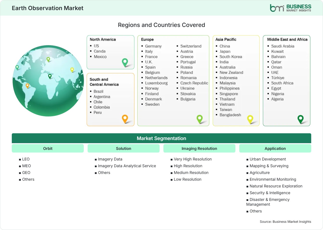
Global Market Geography
FREE PDF
Request your free sample
Request free sample
05 Segment Analysis

Earth Observation Market Segmentation

Orbit

The orbit segment plays a critical role in determining satellite coverage, revisit frequency, data quality, and operational efficiency. It accounted for 55%–58% market share in 2025 and is projected to grow at a CAGR of 10.0%–10.5% during 2026–2033. Increasing deployment of commercial satellite constellations, lower launch costs, and demand for frequent monitoring are shaping the Earth Observation Market scope across defense, agriculture, environmental monitoring, and infrastructure applications.

  • LEO: Leads adoption due to low latency, frequent revisits, high-resolution imaging capabilities, and suitability for commercial satellite constellations supporting real-time observation requirements.
  • MEO: Supports specialized observation applications requiring wider coverage and extended operational capabilities, including navigation-related services and regional monitoring activities.
  • GEO: Remains important for continuous large-area observation because of fixed orbital positioning and applications requiring persistent monitoring of weather and environmental conditions.
  • Others: Includes emerging orbital configurations designed to improve satellite efficiency, coverage flexibility, and specialized observation missions across commercial and government applications.

Solution

The solution segment continues evolving as organizations increasingly require both raw satellite imagery and advanced analytical capabilities for decision-making. It accounted for 46%–49% market share in 2025 and is expected to register a CAGR of 9.2%–9.7% between 2026–2033. Growing adoption of cloud-based analytics platforms and artificial intelligence-enabled processing tools is enhancing the value of satellite data across multiple industries.

  • Imagery Data: Represents a major solution category as organizations use high-resolution satellite images for mapping, monitoring, intelligence, agriculture, and environmental assessment activities.
  • Imagery Data Analytical Service: Experiences strong demand as businesses require processed insights, predictive analytics, and actionable intelligence instead of raw satellite imagery.
  • Others: Includes integrated platforms, data management services, and specialized solutions supporting customized earth observation applications across different industries.

Imaging Resolution

Imaging resolution determines the accuracy, usability, and commercial value of satellite-generated information. The segment accounted for 38%–41% market share in 2025 and is projected to expand at a CAGR of 9.5%–10.0% during 2026–2033. Increasing demand for detailed geographic information and precise monitoring capabilities continues encouraging investment in advanced imaging technologies.

  • Very High Resolution: Gains demand from defense, urban planning, and infrastructure monitoring applications requiring detailed surface-level information and accurate object identification.
  • High Resolution: Widely used for commercial mapping, agriculture analysis, disaster monitoring, and resource management due to balanced accuracy and cost efficiency.
  • Medium Resolution: Supports large-scale environmental monitoring, climate analysis, and regional land assessment where broad coverage is more important than detailed imagery.
  • Low Resolution: Remains suitable for large-area observation, weather monitoring, and long-term environmental studies requiring extensive geographic coverage.

Application

The application segment demonstrates broad adoption across commercial, government, and scientific industries as satellite intelligence becomes increasingly integrated into operational decision-making. It accounted for 42%–45% earth observation market share in 2025 and is anticipated to grow at a CAGR of 9.8%–10.3% during 2026–2033. Expanding climate monitoring requirements, infrastructure development, and security applications continue strengthening demand.

  • Urban Development: Uses satellite imagery for city planning, land-use monitoring, infrastructure assessment, and smart city development initiatives requiring accurate geographic insights.
  • Mapping & Surveying: Supports construction planning, geographic information systems, and land management through accurate spatial data collection and analysis.
  • Agriculture: Expands through precision farming applications that monitor crop health, irrigation requirements, productivity patterns, and resource utilization.
  • Environmental Monitoring: Utilizes satellite data for climate analysis, ecosystem assessment, pollution tracking, and conservation initiatives across global regions.
  • Natural Resource Exploration: Supports mineral identification, forestry management, water resource analysis, and energy exploration through advanced remote sensing capabilities.
  • Security & Intelligence: Remains a critical application area for defense agencies requiring surveillance, border monitoring, and strategic intelligence capabilities.
  • Disaster & Emergency Management: Uses real-time satellite information for disaster assessment, emergency response planning, damage evaluation, and recovery operations.
  • Others: Includes specialized applications across scientific research, maritime monitoring, insurance assessment, and commercial analytics requiring satellite-based insights.

Technology

Technology advancements are improving satellite data accuracy, processing speed, and application diversity across industries. The technology segment accounted for 51%–54% earth observation market share in 2025 and is expected to grow at a CAGR of 9.9%–10.4% through 2026–2033. Continuous innovation in sensors, imaging systems, and artificial intelligence integration is expanding commercial opportunities.

  • Optical Imaging: Remains widely adopted for visible spectrum observation, land monitoring, mapping, and agricultural analysis applications requiring detailed imagery.
  • Radar Imaging: Gains importance due to all-weather monitoring capability, nighttime observation, and suitability for defense, disaster management, and infrastructure assessment.
  • Spectral Imaging: Supports advanced analysis by identifying material characteristics, vegetation conditions, and environmental changes through multiple wavelength measurements.
  • Thermal Imaging: Enables temperature-based monitoring applications including energy management, industrial assessment, fire detection, and environmental analysis.
  • LiDAR: Provides highly accurate three-dimensional mapping capabilities for terrain analysis, urban modeling, forestry management, and infrastructure planning.
06 Market Forces

Earth Observation Market Dynamics

Key Market Drivers

Rising demand for satellite-based monitoring services

Increasing dependence on satellite-derived information across government agencies, commercial enterprises, and research organizations is accelerating demand for advanced monitoring services. The use of satellite images for tracking assets, assessing land, monitoring climate, planning infrastructures, and security purposes is becoming popular because of its capability to provide a constant view of large geographic areas. The increase in the development of private satellite constellations and low-cost launches is increasing data accessibility for end-users. According to the industry insights, commercial satellite firms are now providing their services on a subscription basis to help people get real-time information without owning satellites. These developments continue supporting Earth Observation Market growth by expanding adoption across multiple industries.

Growing climate monitoring and environmental analysis

Rising concerns regarding climate change, natural resource management, and environmental sustainability are increasing the use of satellite observation technologies. Remote sensing data is being used by governments and environmental organizations to track deforestation, carbon emissions, marine life, glacier change, and ecosystem health. Climate policy initiatives have become more dependent on satellite data in order to improve transparency and make decisions based on scientific evidence. Earth observation systems’ capacity for continuous monitoring of distant regions has made them useful for climate risk assessments. Advanced sensors, including hyperspectral and thermal imaging technologies, are further improving environmental analysis capabilities and expanding applications across scientific and commercial sectors.

Increasing adoption of geospatial intelligence solutions

Organizations across defense, agriculture, infrastructure, and urban planning sectors are increasingly adopting geospatial intelligence platforms to improve operational decision-making. Combining satellite imagery with artificial intelligence and machine learning along with Geographic Information Systems has made it possible to increase efficiency in terms of analyzing data and improving predictive capabilities. Companies are leveraging the power of geospatial intelligence in order to make decisions regarding potential markets, asset management, and supply chain optimization. These developments are influencing Earth Observation Market trends as users shift from basic imagery access toward integrated platforms delivering real-time insights and automated analytics.

Key Market Opportunities

Expansion of precision agriculture applications

The agriculture sector represents a significant opportunity as farmers and agribusinesses increasingly adopt satellite-based solutions for crop monitoring, yield estimation, and resource optimization. Earth observation platforms enable precision agriculture to make use of the data gathered on the state of the vegetation, soil condition, need for irrigation, and risks posed by the weather. The need for sustainable agriculture practices has motivated agricultural companies to adopt the approach of using data to increase efficiency and lower resource usage. Satellites have also been able to develop unique solutions. Earth Observation Market Forecasts indicate that expanding agricultural technology adoption will continue creating opportunities for satellite operators and geospatial analytics companies.

Growing infrastructure monitoring opportunities

Infrastructure development projects worldwide are increasing demand for satellite-based monitoring solutions that support construction planning, asset management, and structural assessment. Earth observation technologies are being utilized by governments and private companies to monitor their transportation systems, urban development, pipelines, and construction projects. Using satellites to observe assets makes remote monitoring a cheap process because it replaces the need for physical inspections. The investments that are being made in smart city initiatives will drive the adoption of such technology. Companies offering integrated platforms combining imagery, analytics, and automated reporting are positioned to benefit from growing infrastructure monitoring requirements.

Rising disaster management solution deployments

Increasing frequency of natural disasters is encouraging governments and emergency response organizations to invest in satellite-based disaster management solutions. Earth observation systems play a significant role in floods, forest fires, earthquakes, and storms by providing the necessary information that allows for rapid damage assessment and the development of response plans. Remote sensing technology is essential for the identification of the areas affected, resource allocation, and recovery monitoring. Continued investments in climate resilience and disaster preparedness programs are expected to create new opportunities for satellite companies offering reliable, real-time monitoring capabilities.

Market Restraints and Challenges

High satellite deployment costs limit investments

Developing and operating satellite infrastructure requires substantial capital investment, including spacecraft manufacturing, launch services, ground stations, and maintenance systems. Factor: The high cost of launching a satellite is one of the barriers for companies and institutions that want to establish an ability to independently observe satellites. Impact: Financial limitations can hinder further growth of constellations, limit creativity, and also prevent usage by potential customers due to budgeting issues. Although falling costs of launches and small satellite technology is making the process more accessible, high investments are still a problem.

Data processing complexity delays decision making

The increasing volume and complexity of satellite-generated information create challenges related to storage, processing, interpretation, and timely decision-making. Factor: Large datasets from high-resolution imagery, multispectral sensors, and radar systems require advanced computing infrastructure and specialized analytical expertise. Impact: Organizations without adequate processing capabilities may experience delays in converting raw satellite data into actionable insights, reducing the operational value of observation solutions. Companies are addressing this challenge through cloud-based platforms, artificial intelligence-driven analytics, and automated processing systems that improve efficiency and simplify data interpretation.

07 Company Analysis

Competitive Landscape

The competitive environment is shaped by satellite constellation expansion, advanced imaging capabilities, geospatial analytics, and increasing commercialization of space-based services. Earth Observation Market analysis indicates that leading companies are focusing on high-resolution imaging, artificial intelligence-enabled analytics, cloud-based platforms, and specialized monitoring solutions to address growing demand from defense, agriculture, infrastructure, environmental, and commercial users.

Company Name

Overview

Products and Services Relevant to this Market

Maxar Technologies Inc.

Provides advanced space technology solutions with expertise in satellite imagery, geospatial intelligence, and commercial earth observation services.

High-resolution satellite imagery, geospatial analytics, defense intelligence solutions, mapping services, and satellite systems.

Airbus Defence and Space

Global aerospace company offering satellite systems and earth observation capabilities for government and commercial applications.

Optical satellite imagery, radar observation solutions, environmental monitoring services, mapping platforms, and satellite technologies.

Planet Labs PBC

Operates a large satellite constellation providing frequent earth imagery and geospatial data solutions globally.

Daily satellite imagery, monitoring platforms, agricultural analytics, environmental intelligence, and cloud-based geospatial services.

L3Harris Technologies Inc.

Develops advanced aerospace and defense technologies supporting intelligence, surveillance, and reconnaissance applications.

Satellite sensors, space systems, intelligence solutions, imaging technologies, and defense observation platforms.

BlackSky Technology Inc.

Provides real-time geospatial intelligence through satellite imagery and artificial intelligence-powered analytics.

Real-time earth observation data, monitoring platforms, AI analytics, defense intelligence, and commercial geospatial solutions.

Capella Space Corp.

Specializes in synthetic aperture radar satellite technology for persistent earth observation capabilities.

SAR imagery, all-weather monitoring solutions, security intelligence services, infrastructure monitoring, and disaster assessment platforms.

ICEYE Oy

Develops radar satellite technology focused on rapid monitoring and high-frequency earth observation applications.

SAR satellite imagery, flood monitoring solutions, disaster response data, climate monitoring, and insurance analytics.

Satellogic Inc.

Operates a growing satellite constellation providing high-resolution imagery and geospatial intelligence solutions.

High-resolution imagery, monitoring services, agriculture solutions, mapping data, and commercial observation platforms.

OHB SE

European aerospace company involved in satellite manufacturing and space-based observation programs.

Earth observation satellites, satellite platforms, mission systems, space technologies, and government observation solutions.

Hexagon AB

Provides digital reality solutions combining geospatial data, sensors, and advanced analytics technologies.

Geospatial intelligence platforms, mapping solutions, remote sensing technologies, analytics software, and location-based services.

10 Trust & Transparency

Research Methodology

The market analysis combines proprietary research with secondary data from government agencies, company disclosures, regulatory filings, industry databases and expert interviews. Market estimates are validated through data triangulation, cross-market benchmarking and analyst review.

View Full Research Methodology

11 Questions Answered

Frequently Asked Questions

What does the Earth Observation Market Report include?

The Market Report provides detailed insights into market size, segmentation, competitive landscape, regional trends, technology developments, growth opportunities, and strategic factors influencing future industry expansion.

Which region offers strong growth opportunities?

Asia Pacific presents significant growth potential due to expanding space programs, infrastructure development, agricultural modernization, environmental monitoring requirements, and increasing government investment in satellite-based solutions.

How is artificial intelligence influencing earth observation solutions?

Artificial intelligence improves satellite data processing by automating image analysis, identifying patterns, generating predictive insights, and reducing the time required to convert large datasets into actionable information.

Which orbit type dominates the market?

LEO satellites represent the leading orbit segment because they provide frequent revisit capabilities, lower communication latency, and high-resolution imaging advantages for commercial monitoring and intelligence applications.

What factors are driving the Earth Observation Market?

The market is driven by increasing demand for satellite monitoring services, climate change analysis, precision agriculture applications, infrastructure monitoring, and growing adoption of geospatial intelligence platforms across government and commercial sectors.

Access the Full Earth Observation Market Report

Get segment-level forecasts, regional estimates, competitive benchmarking, company profiles and downloadable Excel datasets.

Access the full Earth Observation Market Report
350 pages PDF & Excel | 2026-08-12