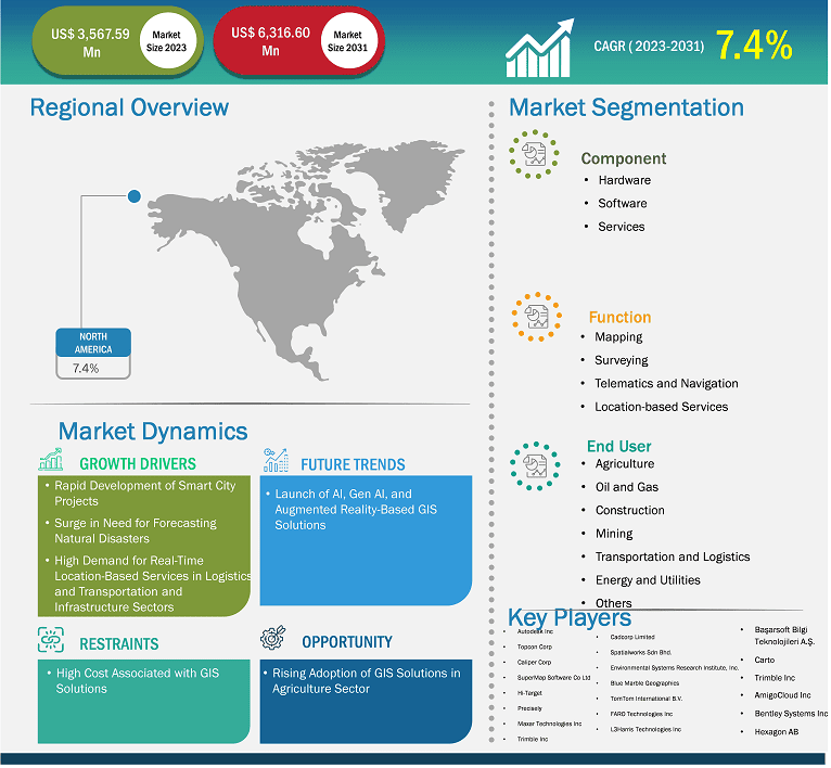
The North America geographic information system market size is expected to reach US$ 6,316.30 million by 2031 from US$ 3,567.59 million in 2023. The market is estimated to record a CAGR of 7.4% from 2023 to 2031.
Executive Summary and North America Geographic Information System Market Analysis:
The US, Canada, and Mexico are the economies in North America. The expansion of aircraft fleets across the region primarily drives the flight planning software industry in North America. Additionally, the growing aviation industry in countries such as the US and Canada drives the flight planning software market. The aviation industry is one of the most notable industries in the US. According to data released by Airlines for America in 2023, commercial aviation accounted for 5% of US GDP and US$ 1.37 trillion in 2023. In addition to the rise in air passenger traffic, government initiatives to increase aircraft fleets in defense and commercial aviation sectors are expected to fuel the demand for flight management solutions such as flight planning software during the forecast period. According to The Insight Partners analysis, in 2023, North America had a fleet of more than 8,000 operational commercial aircraft, which is expected to reach ~10,000 by the end of 2033. Such a large number of operating commercial aircraft will further generate the demand for flight planning software in the region. Additionally, the increase in the number of aircraft fleets across North America is expected to increase the need for flight planning software solutions for applications, including flight route optimization, flight scheduling, reduced fuel consumption, and weather forecasting. Furthermore, one of the factors boosting the flight planning software market is the continued emphasis on increasing regulations related to the safety and security of travelers in the region.
North America Geographic Information System Market Strategic Insights
Get more information on this report
North America Geographic Information System Market Segmentation Analysis
Based on component, the North America geographic information system market is segmented into hardware, software, and services. The software held the largest share of the market in 2023.The hardware segment is further sub segmented intoGIS collectors, imaging sensors, LIDAR, total stations, and GNSS or GPS antennas. The software segment is further sub segmented intodesktop GIS, server GIS, developer GIS, mobile GIS, and remote sensing software.
Based on function, the North America geographic information system market is segmented into mapping, surveying, telematics and navigation, and location-based services. The mapping held the largest share of the market in 2023.
Based on end user, the North America geographic information system market is segmented into agriculture, oil and gas, construction, mining, transportation, energy and power, and others. The transportation held the largest share of the market in 2023.
North America Geographic Information System MarketOutlook
Geographic information system is widely used for the accurate forecasting of storms, hurricanes, and excessive rains. It plays an important role in predicting and mitigating the impact of such natural disaster events by offering essential spatial data, images, and analysis. According to the USA Facts Organizations, in the US, more than 65,000 natural disasters are recorded every year. The US government uses advanced GIS solutions to predict and forecast natural disaster events. From 1980 to 2023, the US recorded and sustained more than 400 weather and climate-related natural disasters, and the overall damage cost exceeded US$ 2.78 trillion. In November 2024, ~24 confirmed weather-related natural disaster events were recorded that cost more than US$ 1 billion. These natural events include one wildfire event, seventeen severe storm events, four tropical cyclone events, and two winter storm events. Thus, the need for forecasting natural disasters fuels the growth of the geographic information system market growth.
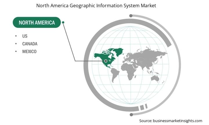
North America Geographic Information System Market Country Insights
Based on country, the North America geographic information system market comprises the US, Canada, and Mexico. The US held the largest share in 2023.
The US is witnessing a rise in the number of oil and gas projects. GIS is used for monitoring and predicting potential geohazards in the oil and gas industry. As per the article published by the NES Fircroft in January 2021, a few of the major oil and gas projects are the Alaska LNG Liquefaction Plant Project (Cost: US$ 43 billion, Location: Alaska, US); Cameron LNG Liquefaction Plant (Cost: US$ 10.2 billion, Location: Louisiana, US); Corpus Christi LNG Liquefaction Plant Project (Cost: US$ 24.5 billion, Location: Texas, US); Driftwood LNG Project (Calcasieu Parish LNG Liquefaction Plant) (Cost: US$ 16 billion, Location: Louisiana, US); and Main Pass Energy Hub (MPEH) LNG Export Terminal (Cost: US$ 15 billion, Location: Louisiana, US); among others.
According to ITA, the US will remain the leading market owing to factors such as a large consumer market, available infrastructure, open investment policy, strong research and development capabilities, automotive production, and local and state government incentives. GIS platforms enable traffic management modifications for the different vast road networks available in the country. In addition, the US is witnessing tremendous growth in its construction industry. According to the US Census Bureau, as of August 2024, the residential construction spending of the US was ~US$ 911,429 million and the non-residential construction spending was US$ 1,220,507 million. GIS is widely used in site analysis, infrastructure planning, and project management. Therefore, the geographic information system market in the US is growing owing to the growth of the oil and gas, transportation, and construction industries.
North America Geographic Information System Market Report Highlights
Report Attribute
Details
Market size in 2023
US$ 3,567.59 Million
Market Size by 2031
US$ 6,316.30 Million
CAGR (2023 - 2031)
7.4%
Historical Data
2021-2022
Forecast period
2024-2031
Segments Covered
By Component
Hardware
Software
Services
By Function
Mapping
Surveying
Telematics and Navigation
Location-based Services
By End User
Agriculture
Oil and Gas
Construction
Mining
Transportation
Energy and Power
Others
Regions and Countries Covered
North America
US, Canada, Mexico
Market leaders and key company profiles
Autodesk Inc
Topcon Corp
Caliper Corp
SuperMap Software Co Ltd
Hi-Target
Precisely
Maxar Technologies Inc
Trimble Inc
AmigoCloud Inc
Bentley Systems Inc
Hexagon AB
Cadcorp Limited
Spatialworks Sdn Bhd.
Environmental Systems Research Institute, Inc.
Blue Marble Geographics
Get more information on this report
North America Geographic Information System Market Company Profiles
Some of the key players operating in the market Autodesk Inc; Topcon Corp; Caliper Corp; SuperMap Software Co Ltd; Hi-Target; Precisely; Maxar Technologies Inc; Trimble Inc; AmigoCloud Inc; Bentley Systems Inc; Hexagon AB; Cadcorp Limited; Spatialworks Sdn Bhd.; Environmental Systems Research Institute, Inc.; Blue Marble Geographics; TomTom International B.V.; FARO Technologies Inc; L3Harris Technologies Inc; Başarsoft Bilgi Teknolojileri A.Ş.; and Carto, among others. These players are adopting various strategies such as expansion, product innovation, and mergers and acquisitions to provide innovative products to their consumers and increase their market share.
North America Geographic Information System Market Research Methodology :
The following methodology has been followed for the collection and analysis of data presented in this report:
Secondary Research
The research process begins with comprehensive secondary research, utilizing both internal and external sources to gather qualitative and quantitative data for each market. Commonly referenced secondary research sources include, but are not limited to:
Company websites, annual reports, financial statements, broker analyses, and investor presentations.
Industry trade journalsand other relevant publications.
Government documents, statistical databases, and market reports.
News articles, press releases, and webcasts specific to companies operating in the market.
Note:All financial data included in the Company Profiles section has been standardized to USD. For companies reporting in other currencies, figures have been converted to USD using the relevant exchange rates for the corresponding year.
Primary Research
The Insight Partners conducts a significant number of primary interviews each year with industry stakeholders and experts to validate its data analysis and gain valuable insights. These research interviews are designed to:
Validate and refine findings from secondary research.
Enhance the expertise and market understanding of the analysis team.
Gain insights into market size, trends, growth patterns, competitive dynamics, and future prospects.
Primary research is conducted via email interactions and telephone interviews, encompassing various markets, categories, segments, and sub-segments across different regions. Participants typically include:
Industry stakeholders: Vice Presidents, business development managers, market intelligence managers, and national sales managers
External experts: Valuation specialists, research analysts, and key opinion leaders with industry-specific expertise
North America Geographic Information System Market Country and Regional Insights
Get more information on this report
Identical Market Reports with other Region/Countries
The List of Companies - North America Geographic Information System Market
Autodesk IncTopcon CorpCaliper CorpSuperMap Software Co LtdHi-TargetPreciselyMaxar Technologies IncTrimble IncAmigoCloud IncBentley Systems IncHexagon ABCadcorp LimitedSpatialworks Sdn Bhd.Environmental Systems Research Institute, Inc.Blue Marble GeographicsTomTom International B.V.FARO Technologies IncL3Harris Technologies IncBasarsoft Bilgi Teknolojileri A.S. Carto
Frequently Asked Questions
How big is the North America Geographic Information System Market?
The North America Geographic Information System Market is valued at US$ 3,567.59 Million in 2023, it is projected to reach US$ 6,316.30 Million by 2031.
What is the CAGR for North America Geographic Information System Market by (2023 - 2031)?
As per our report North America Geographic Information System Market, the market size is valued at US$ 3,567.59 Million in 2023, projecting it to reach US$ 6,316.30 Million by 2031. This translates to a CAGR of approximately 7.4% during the forecast period.
What segments are covered in this report?
The North America Geographic Information System Market report typically cover these key segments-
Component (Hardware, Software, Services)
Function (Mapping, Surveying, Telematics and Navigation, Location-based Services)
End User (Agriculture, Oil and Gas, Construction, Mining, Transportation, Energy and Power, Others)
What is the historic period, base year, and forecast period taken for North America Geographic Information System Market?
The historic period, base year, and forecast period can vary slightly depending on the specific market research report. However, for the North America Geographic Information System Market report:
Historic Period : 2021-2022
Base Year : 2023
Forecast Period : 2024-2031
Who are the major players in North America Geographic Information System Market?
The North America Geographic Information System Market is populated by several key players, each contributing to its growth and innovation. Some of the major players include:
Autodesk Inc
Topcon Corp
Caliper Corp
SuperMap Software Co Ltd
Hi-Target
Precisely
Maxar Technologies Inc
Trimble Inc
AmigoCloud Inc
Bentley Systems Inc
Hexagon AB
Cadcorp Limited
Spatialworks Sdn Bhd.
Environmental Systems Research Institute, Inc.
Blue Marble Geographics
TomTom International B.V.
FARO Technologies Inc
L3Harris Technologies Inc
Basarsoft Bilgi Teknolojileri A.S.
Carto
Who should buy this report?
The North America Geographic Information System Market report is valuable for diverse stakeholders, including:
Investors: Provides insights for investment decisions pertaining to market growth, companies, or industry insights. Helps assess market attractiveness and potential returns.
Industry Players: Offers competitive intelligence, market sizing, and trend analysis to inform strategic planning, product development, and sales strategies.
Suppliers and Manufacturers: Helps understand market demand for components, materials, and services related to concerned industry.
Researchers and Consultants: Provides data and analysis for academic research, consulting projects, and market studies.
Financial Institutions: Helps assess risks and opportunities associated with financing or investing in the concerned market.
Essentially, anyone involved in or considering involvement in the North America Geographic Information System Market value chain can benefit from the information contained in a comprehensive market report.


 Get Free Sample For North America Geographic Information System Market