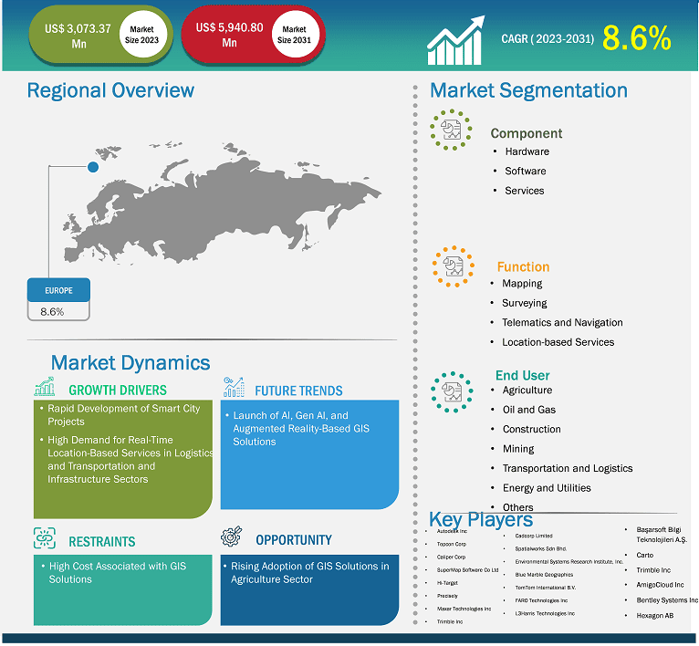
The Europe geographic information system market size is expected to reach US$ 5,940.80 million by 2031 from US$ 3,073.37 million in 2023. The market is estimated to record a CAGR of 8.6% from 2023 to 2031.
Executive Summary and Europe Geographic Information System Market Analysis:
The geographic information system market in Europe is driven by the increasing demand from the automotive and construction sectors. The European Automobile Manufacturers' Association (ACEA) stated that vehicle production in Europe was 18 million units in 2023. Furthermore, more than 12 million passenger cars were produced across the European Union in 2023, an increase of 11.3% compared to 2022. Automotive manufacturers in Europe are adopting geographic information systems to meet the growing demand for mapping and navigation. Major manufacturers such as General Motors have adopted spatial analytics solutions for its more than 4,300 GM dealers to meet local and global demand and further expand their business.
The automotive industry in Europe accounted for ~20% of global production of vehicles in 2022. The adoption of connected vehicles is gaining momentum across the region. Connected vehicles comprise geographic information systems with software, hardware, and other solutions. These GIS solutions include ArcGIS, QGIS, and SAGA GIS, among others. The adoption is driven by consumer preferences, regulatory measures, and safety standards, and an increase in the implementation of advanced driver assistance systems (ADAS) and vehicle-to-everything (V2X) communication. Governments of various countries in Europe are actively supporting the deployment of connected vehicles to enhance road safety and reduce emissions. Cooperative Intelligent Transport Systems (C-ITS) is one of the EU's connected vehicle projects. Successful implementation of this system will enable information exchange between vehicles and the road infrastructure. The C-ROADS Platform, which enables the uniform deployment of C-ITS operations across Europe, is being developed in collaboration with road authorities and operators. Many notable countries in Europe, such as Germany, Spain, France, and the UK, are investing heavily in developing suitable infrastructure for connected mobility. For instance, Spain is building its first intelligent highways. In this project, Kapsch TrafficCom's technology and software will enable the digitalization of a 60 km section of the A8 motorway near Bilbao by 2024. Also, in July 2024, the EU Commission planned to invest more than US$ 7.62 billion for the safe, sustainable, and smart transportation infrastructure project. The European Commission selected more than 134 transportation projects to receive more than US$ 7.61 billion under an EU grant for the Connecting Europe Facility (CEF).
Europe Geographic Information System Market Strategic Insights
Get more information on this report
Europe Geographic Information System Market Segmentation Analysis
Based on component, the Europe geographic information system market is segmented into hardware, software, and services. The software held the largest share of the market in 2023.The hardware segment is further sub segmented intoGIS collectors, imaging sensors, LIDAR, total stations, and GNSS or GPS antennas. The software segment is further sub segmented intodesktop GIS, server GIS, developer GIS, mobile GIS, and remote sensing software.
Based on function, the Europe geographic information system market is segmented into mapping, surveying, telematics and navigation, and location-based services. The mapping held the largest share of the market in 2023.
Based on end user, the Europe geographic information system market is segmented into agriculture, oil and gas, construction, mining, transportation, energy and power, and others. The transportation held the largest share of the market in 2023.
Europe Geographic Information System MarketOutlook
In smart city projects, a geographic information system (GIS) is used for site selection, land acquisition, urban town planning, designing, visualization, construction, project management, and reporting. The development of smart city projects is proliferating with significant investment from governments of several countries across the world. According to The Organisation for Economic Co-operation and Development (OECD), the smart city market was valued at US$ 511.6 billion in 2022 and is projected to reach US$ 1,024 billion by 2027; it is expected to register a CAGR of 15% during the forecast period. Additionally, geographic information system integrated solutions such as Building Information Modeling (BIM) are being widely used for the construction of town planning. As of 2023, many countries in Europe have initiated more than 170 smart city projects with significant investments. The major countries include Netherlands, Italy, Germany, France, Spain and many others. European Investment Bank provided more than US$ 23.13 billion to support the development of sustainable smart cities project development in Europe. Thus, the rapid development of smart city projects and growing infrastructure development projects across the globe drives the geographic information system market.
Europe Geographic Information System Market Country Insights
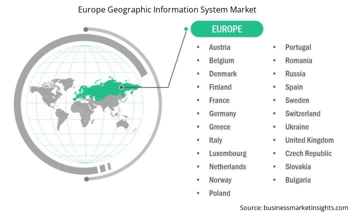
Based on country, the Europe geographic information system market comprises the UK, Germany, France, Russia, Italy, and the Rest of Europe. The UK held the largest share in 2023.
The UK construction sector is one of the largest markets worldwide. As per the data published by the government of the UK in 2023, the new construction output increased by 16% in 2022 to reach a record-high value of US$ 130 billion. In this new construction output, new residential construction dominated the total new construction output with a share of more than 42%. As per the government, the new orders increased by 11.4% to reach US$ 100 billion in 2022. Also, in 2023, the government invested heavily in public infrastructure. According to the Office for National Statistics in 2024, the infrastructure investments of the country increased to US$ 19 billion in 2023, a 3.9% growth from 2022. With such investments by the government and increased demand for residential construction, the demand for scaffoldings in the UK is expected to increase in the coming years. With increasing construction activities across the country have created massive demand for the geographic information system market growth.
Europe Geographic Information System Market Report Highlights
Report Attribute
Details
Market size in 2023
US$ 3,073.37 Million
Market Size by 2031
US$ 5,940.80 Million
CAGR (2023 - 2031)
8.6%
Historical Data
2021-2022
Forecast period
2024-2031
Segments Covered
By Component
Hardware
Software
Services
By Function
Mapping
Surveying
Telematics and Navigation
Location-based Services
By End User
Agriculture
Oil and Gas
Construction
Mining
Transportation
Energy and Power
Others
Regions and Countries Covered
Europe
Germany, France, Italy, UK, Italy, Rest of Europe
Market leaders and key company profiles
Autodesk Inc
Topcon Corp
Caliper Corp
SuperMap Software Co Ltd
Hi-Target
Precisely
Maxar Technologies Inc
Trimble Inc
AmigoCloud Inc
Bentley Systems Inc
Hexagon AB
Cadcorp Limited
Spatialworks Sdn Bhd.
Environmental Systems Research Institute, Inc.
Blue Marble Geographics
Get more information on this report
Europe Geographic Information System Market Company Profiles
Some of the key players operating in the market include Autodesk Inc; Topcon Corp; Caliper Corp; SuperMap Software Co Ltd; Hi-Target; Precisely; Maxar Technologies Inc; Trimble Inc; AmigoCloud Inc; Bentley Systems Inc; Hexagon AB; Cadcorp Limited; Spatialworks Sdn Bhd.; Environmental Systems Research Institute, Inc.; Blue Marble Geographics; TomTom International B.V.; FARO Technologies Inc; L3Harris Technologies Inc; Basarsoft Bilgi Teknolojileri A.S.; and Carto, among others. These players are adopting various strategies such as expansion, product innovation, and mergers and acquisitions to provide innovative products to their consumers and increase their market share.
Europe Geographic Information System Market Research Methodology :
The following methodology has been followed for the collection and analysis of data presented in this report:
Secondary Research
The research process begins with comprehensive secondary research, utilizing both internal and external sources to gather qualitative and quantitative data for each market. Commonly referenced secondary research sources include, but are not limited to:
Company websites, annual reports, financial statements, broker analyses, and investor presentations.
Industry trade journalsand other relevant publications.
Government documents, statistical databases, and market reports.
News articles, press releases, and webcasts specific to companies operating in the market.
Note:All financial data included in the Company Profiles section has been standardized to USD. For companies reporting in other currencies, figures have been converted to USD using the relevant exchange rates for the corresponding year.
Primary Research
The Insight Partners conducts a significant number of primary interviews each year with industry stakeholders and experts to validate its data analysis and gain valuable insights. These research interviews are designed to:
Validate and refine findings from secondary research.
Enhance the expertise and market understanding of the analysis team.
Gain insights into market size, trends, growth patterns, competitive dynamics, and future prospects.
Primary research is conducted via email interactions and telephone interviews, encompassing various markets, categories, segments, and sub-segments across different regions. Participants typically include:
Industry stakeholders: Vice Presidents, business development managers, market intelligence managers, and national sales managers
External experts: Valuation specialists, research analysts, and key opinion leaders with industry-specific expertise
Europe Geographic Information System Market Country and Regional Insights
Get more information on this report
Identical Market Reports with other Region/Countries
The List of Companies - Europe Geographic Information System Market
Autodesk IncTopcon CorpCaliper CorpSuperMap Software Co LtdHi-TargetPreciselyMaxar Technologies IncTrimble IncAmigoCloud IncBentley Systems IncHexagon ABCadcorp LimitedSpatialworks Sdn Bhd.Environmental Systems Research Institute, Inc.Blue Marble GeographicsTomTom International B.V.FARO Technologies IncL3Harris Technologies IncBasarsoft Bilgi Teknolojileri A.S.Carto
Frequently Asked Questions
How big is the Europe Geographic Information System Market?
The Europe Geographic Information System Market is valued at US$ 3,073.37 Million in 2023, it is projected to reach US$ 5,940.80 Million by 2031.
What is the CAGR for Europe Geographic Information System Market by (2023 - 2031)?
As per our report Europe Geographic Information System Market, the market size is valued at US$ 3,073.37 Million in 2023, projecting it to reach US$ 5,940.80 Million by 2031. This translates to a CAGR of approximately 8.6% during the forecast period.
What segments are covered in this report?
The Europe Geographic Information System Market report typically cover these key segments-
Component (Hardware, Software, Services)
Function (Mapping, Surveying, Telematics and Navigation, Location-based Services)
End User (Agriculture, Oil and Gas, Construction, Mining, Transportation, Energy and Power, Others)
What is the historic period, base year, and forecast period taken for Europe Geographic Information System Market?
The historic period, base year, and forecast period can vary slightly depending on the specific market research report. However, for the Europe Geographic Information System Market report:
Historic Period : 2021-2022
Base Year : 2023
Forecast Period : 2024-2031
Who are the major players in Europe Geographic Information System Market?
The Europe Geographic Information System Market is populated by several key players, each contributing to its growth and innovation. Some of the major players include:
Autodesk Inc
Topcon Corp
Caliper Corp
SuperMap Software Co Ltd
Hi-Target
Precisely
Maxar Technologies Inc
Trimble Inc
AmigoCloud Inc
Bentley Systems Inc
Hexagon AB
Cadcorp Limited
Spatialworks Sdn Bhd.
Environmental Systems Research Institute, Inc.
Blue Marble Geographics
TomTom International B.V.
FARO Technologies Inc
L3Harris Technologies Inc
Basarsoft Bilgi Teknolojileri A.S.
Carto
Who should buy this report?
The Europe Geographic Information System Market report is valuable for diverse stakeholders, including:
Investors: Provides insights for investment decisions pertaining to market growth, companies, or industry insights. Helps assess market attractiveness and potential returns.
Industry Players: Offers competitive intelligence, market sizing, and trend analysis to inform strategic planning, product development, and sales strategies.
Suppliers and Manufacturers: Helps understand market demand for components, materials, and services related to concerned industry.
Researchers and Consultants: Provides data and analysis for academic research, consulting projects, and market studies.
Financial Institutions: Helps assess risks and opportunities associated with financing or investing in the concerned market.
Essentially, anyone involved in or considering involvement in the Europe Geographic Information System Market value chain can benefit from the information contained in a comprehensive market report.


 Get Free Sample For Europe Geographic Information System Market