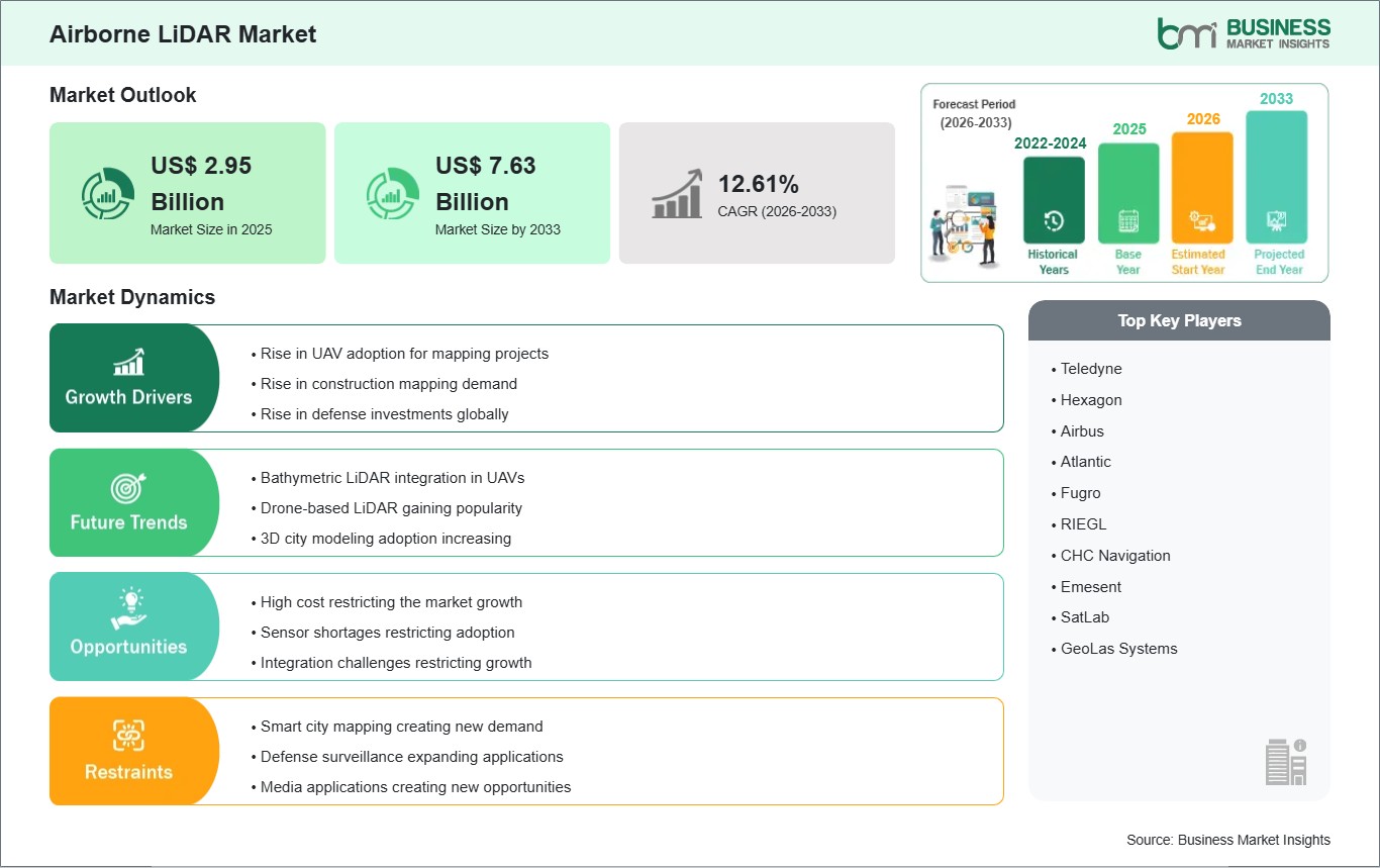
The Airborne LiDAR Market size is expected to reach US$ 7.63 Billion by 2033 from US$ 2.95 Billion in 2025.The market is estimated to record a CAGR of 12.61% from 2026 to 2033.
Executive Summary and Global Market Analysis:
Airborne LiDAR is a remote sensing technology that uses laser pulses from aircraft or drones to create highly accurate three-dimensional maps and terrain models. The technology is widely used in applications such as land surveying, infrastructure planning, environmental monitoring, mining analysis, forestry management, and defense surveillance. The market is expanding as governments and private organizations increasingly rely on advanced geospatial data for decision-making and operational planning. The growing use of unmanned aerial vehicles, digital mapping systems, and smart infrastructure projects is supporting broader adoption of Airborne LiDAR solutions across multiple industries. Demand is also rising for high-resolution terrain imaging in flood mapping, disaster response, and transportation development projects.
There are several challenges affecting market expansion. High equipment and operational costs remain a concern, especially for smaller surveying firms and developing regions with limited investment capacity. Data processing and storage requirements are also increasing due to the large volume of information generated during LiDAR operations. In addition, regulatory restrictions related to aerial surveys and airspace management can delay project approvals in some countries. The shortage of skilled professionals capable of managing advanced LiDAR systems and interpreting geospatial datasets may further limit operational efficiency. Weather conditions and geographic complexity can also influence data accuracy and increase operational timelines in remote locations.
Despite these limitations, the market is expected to witness strong growth due to advancements in sensor technologies, artificial intelligence-based mapping software, and cloud-enabled geospatial platforms. Topographic LiDAR continues to dominate because of its broad use in land and infrastructure mapping, while bathymetric LiDAR is gaining attention for coastal and underwater terrain analysis. Hardware solutions account for a significant market share owing to continuous upgrades in laser scanning systems and airborne sensors. Aerospace & defense and mining industries remain major adopters as organizations focus on accurate terrain intelligence, operational safety, and resource management.
Airborne LiDAR Market - Strategic Insights:
Get more information on this report
Airborne LiDAR Market Segmentation Analysis:
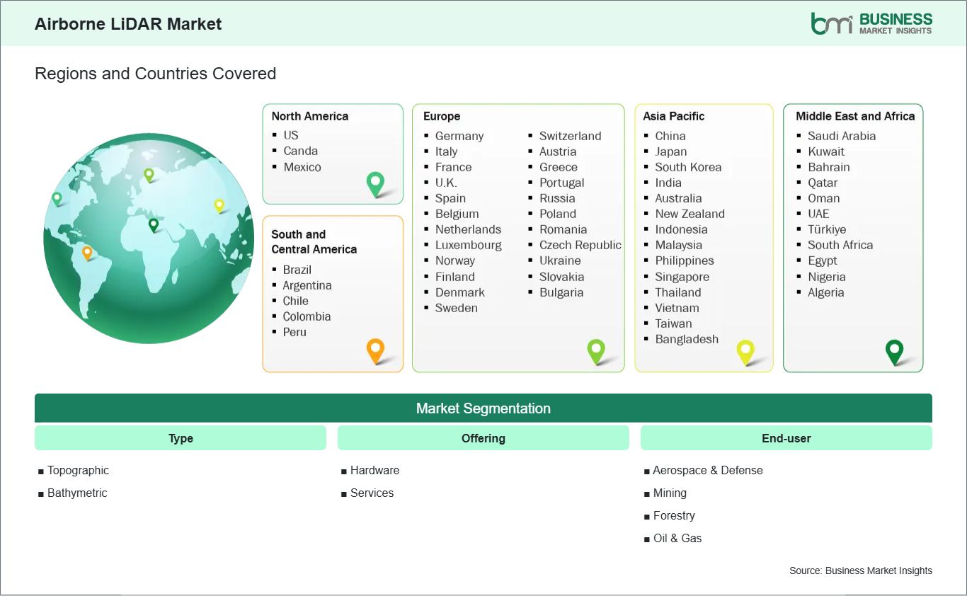
The Airborne LiDAR market is segmented by type, offering, and end-user. Growing demand for high-precision geospatial data and terrain intelligence is supporting adoption across multiple industrial and commercial sectors.
By Type
Topographic: Widely used for terrain mapping, urban planning, infrastructure development, and forestry management applications.
Bathymetric: Increasingly adopted for coastal mapping, underwater terrain analysis, and marine environmental monitoring projects.
By Offering
Hardware: Includes laser scanners, GPS systems, sensors, and imaging equipment required for airborne surveying operations.
Services: Covers data processing, mapping, consulting, maintenance, and geospatial analytics services.
By End-User
Aerospace & Defense: Uses Airborne LiDAR for surveillance, mission planning, border monitoring, and tactical mapping.
Mining: Supports mineral exploration, volumetric analysis, and operational planning in mining sites.
Forestry: Helps in vegetation analysis, forest inventory management, and environmental assessment activities.
Oil & Gas: Used for pipeline monitoring, route planning, and terrain evaluation in exploration projects.
Airborne LiDAR Market Drivers and Opportunities:
Growing Demand for High-Resolution Geospatial Intelligence
The increasing need for accurate geospatial information across infrastructure, environmental, and defense sectors is driving growth in the Airborne LiDAR market. Governments and private organizations are investing in advanced mapping technologies to improve planning, monitoring, and risk assessment capabilities. Airborne LiDAR systems provide highly detailed terrain data that supports construction projects, transportation development, urban expansion, and disaster management operations. The growing focus on smart city initiatives and digital infrastructure planning is also increasing the demand for precise aerial surveying solutions.
In the defense sector, airborne surveillance and intelligence operations require advanced terrain mapping systems for mission planning and border monitoring. Environmental agencies are also using LiDAR technologies for flood prediction, forest management, and coastal monitoring activities. Improvements in laser scanning accuracy, drone integration, and real-time data processing are making airborne systems more efficient and reliable. Regulatory agencies in several regions are supporting the adoption of geospatial technologies to improve infrastructure resilience and environmental monitoring. These factors continue to strengthen the market outlook for advanced airborne mapping solutions.
Expansion of Drone-Based and AI-Enabled Surveying Solutions
Emerging opportunities in the Airborne LiDAR market are linked to the growing use of drone-based surveying systems and artificial intelligence-enabled data analytics platforms. Unmanned aerial vehicles equipped with compact LiDAR sensors are improving operational flexibility and reducing surveying costs in difficult terrain areas. Industries such as mining, agriculture, and forestry are increasingly using drone-mounted LiDAR systems to collect accurate terrain and vegetation data more efficiently.
Artificial intelligence and machine learning technologies are also transforming the way LiDAR datasets are processed and analyzed. Automated feature extraction, predictive mapping, and cloud-based geospatial platforms are helping organizations manage large volumes of data with improved speed and accuracy. Coastal monitoring and underwater terrain analysis are creating additional opportunities for bathymetric LiDAR systems, especially in climate adaptation and marine infrastructure projects. The growing use of digital twins and 3D modeling technologies is further increasing demand for high-quality airborne mapping data. As industries continue to prioritize automation and data-driven planning, the adoption of advanced Airborne LiDAR technologies is expected to expand steadily across global markets.
Airborne LiDAR Market Size and Share Analysis:
The Airborne LiDAR Market is projected to grow from US$ 2.95 Billion in 2025 to US$ 7.63 Billion by 2033 , registering a CAGR of 12.61% from 2026 to 2033.
By type, topographic LiDAR holds a significant share due to its extensive use in terrain mapping, urban planning, infrastructure monitoring, and forestry management. Bathymetric LiDAR is witnessing growing adoption as governments and environmental agencies increase investments in coastal monitoring, marine surveying, and underwater terrain analysis projects.
By offering, hardware accounts for a major share of the market because of continuous demand for advanced laser scanners, airborne sensors, GPS systems, and imaging technologies. Services are also expanding steadily as organizations require specialized support for data processing, mapping analysis, maintenance, and geospatial consulting.
By end-user, aerospace & defense remains a key contributor owing to increasing use of airborne intelligence and surveillance technologies. Mining and forestry sectors are also generating strong demand for accurate terrain data to improve operational planning, resource assessment, and environmental management activities. Oil & gas applications continue to grow with rising use of LiDAR systems for pipeline inspection and route monitoring projects.
China, Japan, South Korea, India, Australia, New Zealand, Indonesia, Malaysia, Philippines, Singapore, Thailand, Vietnam, Taiwan, Bangladesh
South and Central America
Brazil, Argentina, Chile, Colombia, Peru
Middle East and Africa
Saudi Arabia, United Arab Emirates, Kuwait, Bahrain, Qatar, Oman, Turkiye, South Africa, Egypt, Nigeria, Algeria
Market leaders and key company profiles
Teledyne
Hexagon
Airbus
Atlantic
Fugro
RIEGL
CHC Navigation
Emesent
SatLab
GeoLas Systems
Get more information on this report
Airborne LiDAR Market Report Coverage and Deliverables:
The "Airborne LiDAR Size and Forecast (2022-2033)" report provides a detailed analysis of the market covering below areas:
Market size and forecast at global, regional, and country levels for all the key market segments covered under the scope
Market trends, as well as market dynamics such as drivers, restraints, and key opportunities
Market analysis covering key market trends, global and regional framework, major players, regulations, and recent market developments
Industry landscape and competition analysis covering market concentration, heat map analysis, prominent players, and recent developments for the market
Detailed company profiles, including SWOT analysis
Airborne LiDAR Market Geographic Insights:
The Airborne LiDAR Market shows diverse regional adoption patterns influenced by infrastructure modernization programs, geospatial mapping requirements, environmental monitoring initiatives, and defense surveillance investments.
North America remains one of the leading regions for Airborne LiDAR adoption due to strong investment in geospatial intelligence, transportation infrastructure, and environmental management projects. The United States continues to use airborne mapping technologies extensively for defense surveillance, flood mapping, forestry management, and urban planning activities. Canada is expanding the use of LiDAR systems in mining exploration, pipeline monitoring, and natural resource assessment. Regional agencies are increasingly adopting drone-based surveying systems to improve efficiency and reduce operational costs. The presence of advanced aerospace and geospatial technology ecosystems also supports continuous innovation and adoption across the region.
Asia Pacific is witnessing rapid growth in the Airborne LiDAR market due to expanding infrastructure projects, smart city initiatives, and natural disaster monitoring requirements. China is investing heavily in digital mapping, transportation planning, and environmental assessment technologies to support urban development projects. India is increasing the use of airborne surveying systems for infrastructure modernization, mining operations, and land management programs. Japan and Australia are also adopting LiDAR technologies for coastal monitoring, forestry analysis, and disaster preparedness applications. Growing industrialization, rising adoption of drone technologies, and increasing government focus on geospatial intelligence are supporting regional market expansion.
Get more information on this report
Airborne LiDAR Market Research Report Guidance:
The report includes qualitative and quantitative data pertaining to the Airborne LiDAR market, categorized by type, offering, end-user, and geography.
The report starts with the key takeaways (chapter 2), highlighting the key trends and outlook of the Airborne LiDAR market.
Chapter 3 focuses on the research methodology of the study.
Chapter 4 includes ecosystem analysis.
Chapter 5 highlights the major industry dynamics in the Airborne LiDAR market, including factors that are driving the market, prevailing deterrents, potential opportunities, as well as future trends. Impact analysis of these drivers and restraints is also covered in this section.
Chapter 6 discusses the Airborne LiDAR market scenario, in terms of historical market revenues, and forecast till the year 2033.
Chapters 7 to 10 cover Airborne LiDAR market segments by type, offering, end-user, and geography across North America, Europe, Asia Pacific, Middle East and Africa, and South and Central America. They cover the market revenue, forecast, and factors driving the market.
Chapter 11 describes the competitive analysis along with the heat map analysis for the key players operating in the market.
Chapter 12 describes the industry landscape analysis. It provides detailed descriptions of business activities such as market initiatives, new developments, mergers, and joint ventures globally, along with a competitive landscape.
Chapter 13 provides detailed profiles of the major companies operating in the Airborne LiDAR market. Companies have been profiled on the basis of their key facts, business descriptions, products and services, financial overview, SWOT analysis, and key developments.
Chapter 14, i.e., the appendix, is inclusive of a brief overview of the company, list of abbreviations, and disclaimer.
Airborne LiDAR Market News and Key Development:
The Airborne LiDAR Market is analyzed using a mix of primary and secondary research sources, including corporate publications, industry associations, and verified databases. This approach ensures accurate tracking of innovation trends and strategic developments influencing the market.
In February 2024, Leica Geosystems introduced an advanced airborne LiDAR solution designed for large-scale terrain mapping and infrastructure monitoring applications. The system focused on improving point cloud density, operational efficiency, and data accuracy for geospatial projects. The launch strengthened the use of LiDAR technologies in smart infrastructure and environmental management operations.
In September 2023, Teledyne Geospatial announced enhancements to its airborne bathymetric LiDAR technology for coastal and underwater mapping projects. The development aimed to improve marine terrain analysis and support environmental monitoring activities in coastal regions. The upgrade reflected growing demand for advanced airborne surveying technologies in marine and infrastructure applications.
Key Sources Referred:
World Bank - Global Trade Indicators
World Trade Organization (WTO)
International Monetary Fund (IMF)
International Trade Administration (ITA)
Company Websites
Company Annual Reports
Company Investor Presentations
The List of Companies - Airborne LiDAR Market
Teledyne
Hexagon
Airbus
Atlantic
Fugro
RIEGL
CHC Navigation
Emesent
SatLab
GeoLas Systems
Frequently Asked Questions
How big is the Airborne LiDAR Market?
The Airborne LiDAR Market is valued at US$ 2.95 Billion in 2025, it is projected to reach US$ 7.63 Billion by 2033.
What is the CAGR for Airborne LiDAR Market by (2026 - 2033)?
As per our report Airborne LiDAR Market, the market size is valued at US$ 2.95 Billion in 2025, projecting it to reach US$ 7.63 Billion by 2033. This translates to a CAGR of approximately 12.61% during the forecast period.
What segments are covered in this report?
The Airborne LiDAR Market report typically cover these key segments-
What is the historic period, base year, and forecast period taken for Airborne LiDAR Market?
The historic period, base year, and forecast period can vary slightly depending on the specific market research report. However, for the Airborne LiDAR Market report:
Historic Period : 2022-2024
Base Year : 2025
Forecast Period : 2026-2033
Who are the major players in Airborne LiDAR Market?
The Airborne LiDAR Market is populated by several key players, each contributing to its growth and innovation. Some of the major players include:
Teledyne
Hexagon
Airbus
Atlantic
Fugro
RIEGL
CHC Navigation
Emesent
SatLab
GeoLas Systems
Who should buy this report?
The Airborne LiDAR Market report is valuable for diverse stakeholders, including:
Investors: Provides insights for investment decisions pertaining to market growth, companies, or industry insights. Helps assess market attractiveness and potential returns.
Industry Players: Offers competitive intelligence, market sizing, and trend analysis to inform strategic planning, product development, and sales strategies.
Suppliers and Manufacturers: Helps understand market demand for components, materials, and services related to concerned industry.
Researchers and Consultants: Provides data and analysis for academic research, consulting projects, and market studies.
Financial Institutions: Helps assess risks and opportunities associated with financing or investing in the concerned market.
Essentially, anyone involved in or considering involvement in the Airborne LiDAR Market value chain can benefit from the information contained in a comprehensive market report.


 Get Free Sample For Airborne LiDAR Market